You may hate it or love it but either way we have now entered meteorological winter. Of course, the months of December, January and February on average are the coldest months of the year here in west Michigan. In most winters they are the months with the most snow fall. Records have been kept here at Grand Rapids since 1892 in the years 1892 to 1895 there is some missing data. The location from where records are taken from appears to have moved 3 times. For a location somewhere downtown to the old airport between 36th and 44th streets near Kalamazoo ave. That airport opened in 1927 but not sure when the weather station moved there. And since November 23rd, 1963 the official NWS office moved to its current location. At Lansing the records there go all the way back to April 1863. The Lansing airport has been at its current location since 1928 I am not sure where the weather station was located before being at the airport.
Meteorological Winter
The current 30 average temperature at Grand Rapids for the months of December, January and February is 27.3. That is up from the old 30 year average of 26.8 (The new 15 year average is 27.4) The warmest meteorological winter at Grand Rapids is 33.9 set in 1931/32 The coldest is 18.2 set in 1903/04 The average snow fall at Grand Rapids for December to February is 60.6” The snowiest meteorological winter was the 105.6” that fell in the 3 months in 2013/14 the total that season was 116.0. The least snow fall for any meteorological winter came in 1982/83 when just 11.8”fell. the total for that season was just 35.9” At Lansing the 30 year average mean temperature for meteorological winter is 26.4. The meteorological winter snow fall there is 35.5” and for the winter season the average snow fall is 50.2” Last year the meteorological winter mean temperature at Grand Rapids was a very mild 30.9° that was a departure of +3.6. At Lansing the meteorological winter mean last year was 31.9. As for snow fall there was a total of 110.7” November (28.0) and December (39.0) had 67.0” while January just (13.3) and February (5.7”) had just 19.0” Giving a good amount of mid-winter with little to no snow on the ground. Lansing had a total of 58.1” of snow fall last winter season.
December
The current 30 year mean temperature at Grand Rapids for December is 30.4. The warmest day in December is 69 and that was on December 5, 2001 The coldest low in December is -18 and that was on December 5, 1983. The warmest mean temperature for any December is 39.1° in 2015 the coldest mean for any December is 17.1 in 1989. The average December snow fall at Grand Rapids is 20.8” the most snow to fall in any December is 59.2” in 2000 the least snow fall is 1” that fell in 2014 Last year 39.0”” of snow fell in December. At Lansing the 30 year average temperature is 29.5 and the average snow fall amount is 11.3. The warmest mean was 39.0 in 2015 and the coldest was 13.9 in 1876. The most snow fall was in 2000 with 33.5” and the least snowfall was in 1889 when no snow fall was reported. The record high of 70 was set on December 31 1875 that was in the middle of a 4 day “heat wave” that saw highs of 60,70,65 and 62. The record low for December at Lansing is -25 on December 18, 1884.
With an El Nino winter in progress we will have to see just how this winter will play out. My guess at this time is for temperatures near what they were last winter at around 30° but with much less snow fall around 55”. We shall see.
AREA FORECAST DISCUSSION
NATIONAL WEATHER SERVICE GRAND RAPIDS MI
329 AM EST SAT DEC 2 2023
LATEST UPDATE...
SHORT TERM/LONG TERM/MARINE
SHORT TERM
(TODAY THROUGH SUNDAY)
ISSUED AT 329 AM EST SAT DEC 2 2023
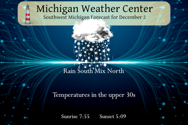
PRECIPITATION CONTINUES EARLY THIS MORNING WITH I-96 ACTING AS THE
DEMARCATION LINE BETWEEN RAIN AND SNOW - SNOW TO THE NORTH, RAIN TO
THE SOUTH. FOR AREAS THAT ARE GETTING SNOW, AIR TEMPS ARE STILL
RIGHT AROUND FREEZING BUT ROAD SURFACE TEMPERATURES ARE SUB-FREEZING.
MDOT MI DRIVE MAP INDICATES REDUCED TRAVEL SPEEDS NORTH OF I-96
AND WEBCAMS CONFIRM WET ROAD SURFACES AND EVEN A LITTLE SNOW
ACCUMULATION NORTH OF M-46. TRAVEL MAY BE SLICK EARLY THIS
MORNING FOR AREAS NORTH OF I-96. PRECIPITATION WILL GRADUALLY WIND
DOWN OVER THE NEXT FEW HOURS AS SHORTWAVE ENERGY EJECTS EAST AND
DEEPER MOISTURE MOVES AWAY WITH IT. SOME DRIZZLE AND LOW CLOUDS
WILL STICK AROUND THE REST OF THE DAY WITH TEMPS WARMING INTO THE
UPPER 30S.
A SHORTWAVE EMBEDDED IN A LARGER LONGWAVE TROUGH WILL BRING RENEWED
PRECIPITATION CHANCES EARLY SUNDAY. MARGINAL TEMPERATURES WILL
BRING A TYPICAL RAIN/SNOW MIX SCENARIO ACROSS THE AREA, WITH
MAINLY SNOW NORTH OF I-96 AND RAIN TO THE SOUTH. MINOR WINTERLIKE
IMPACTS WILL BE POSSIBLE BY SUNDAY WITH ACCUMULATIONS OF 1-3
INCHES OR LESS OF WET SNOW POSSIBLE.
LONG TERM
(SUNDAY NIGHT THROUGH FRIDAY)
ISSUED AT 329 AM EST SAT DEC 2 2023
THE LONG TERM PERIOD REMAINS UNSETTLED WITH NUMEROUS PRECIPITATION
CHANCES. TEMPERATURES WILL BE NEAR TO SLIGHTLY ABOVE NORMAL THROUGH
MIDWEEK THEN FIRMLY IN THE ABOVE NORMAL CATEGORY TO END THE WEEK.
THE FINAL IN THE SERIES OF SRN STREAM SYSTEMS DEPARTS LATE SUNDAY
NIGHT THEN IT APPEARS WE GET A BRIEF RESPITE FROM RAIN/SNOW ON
MONDAY BEFORE ANOTHER SYSTEM DROPS IN VIA NORTHWEST FLOW FOR LATE
MONDAY NIGHT AND TUESDAY.
THIS CLIPPER TYPE SYSTEM WILL HAVE LESS MOISTURE TO WORK WITH THAN
ITS SRN STREAM PREDECESSORS BUT SNOW EXPECTED TO BE THE MORE
LIKELY/DOMINANT PRECIP TYPE AS IT ARRIVES LATE MONDAY NIGHT.
ANY SNOW ACCUMS SHOULD BE ON THE LIGHTER SIDE GIVEN QPF AMOUNTS
UNDER 0.25" BUT THERE MAY BE ENOUGH OF A COATING OVERNIGHT TO CREATE
A SLICK TUESDAY MORNING COMMUTE FOR MUCH OF THE AREA. THE SNOW
SHOULD CHANGE TO RAIN OR A RAIN/SNOW MIX IN THE AFTERNOON AS TEMPS
WARM WELL INTO THE 30S.
PERSISTENT LONGWAVE TROUGHING FINALLY DEPARTS THE REGION MIDWEEK AS
RIDGING NUDGES IN FROM THE WEST. A PUSH OF MILDER AIR ACCOMPANIES
THAT RIDGING AND WE END THE WEEK WITH HIGHS IN THE 40S. THE WARM
ADVECTION PATTERN COULD PRODUCE ADDITIONAL BOUTS OF LIGHT PRECIP,
ALTHOUGH P-TYPE SHOULD EVENTUALLY FAVOR MOSTLY RAIN BY THUR-FRI.
Detailed Forecast For Grand Rapids
The official H/L at Grand Rapids yesterday was 40/33. That 40 was recorded at 2:30AM during the day there was a cold rain mixed with snow with 0.46” of rain and a official trace of snowfall. The average H/L for today is 40/28 the record high of 67 was set in 1982 and the record low of -11 was set in 1976 the wettest day was 1.48” that was in 1982 so that was a warm and wet day in 1982. The most snowfall of 4.8” fell in 1985 the most snow on the ground was 12” in 1940. Last year the H/L was 51/32 and there was 0.03” of rain.
Weather history for SW Michigan
1976: One of the coldest winters of the 20th century gets off to an early start, continuing the persistently cold pattern that began during the autumn. Temperatures plunge to record lows of 11 degrees below zero at Grand Rapids and 2 below zero at Muskegon.
1982: Low temperatures on this day are only in the mid 50s across southwest Lower Michigan, the warmest on record for December. The afternoon temperatures are in the mid and upper 60s. Muskegon hits 64 degrees, a record high for the month of December there.
GO BLUE
+1
GO BLUE!!
From Bill Steffen just the other day and also alluded to this a bit this morning:
“Looks like December starts on the mild side with temperatures a touch above average for the first 2-3 weeks of the month. It looks to me like we’ll see a turn toward a colder pattern around or shortly before Christmas and January could turn out to be a chilly month.“
No doubt and I see a major snowstorm by the 3rd week of December! Mark it down and get ready!
Yesterday’s snowfall total = just under 2 inches! Keep it rocking!