
Welcome to the first day of meteorological winter! Today won’t be the most pleasant of days unless you like rain and heavy cement-like snow. The best chance of snow will be near and north of I96, areas south will see a mix or all rain.
Grand Rapids Forecast
Kalamazoo Forecast
Weather History for SW Michigan
2006: A snow and ice storm strikes southwest Lower Michigan. From 6 to 12 inches of snow falls from Muskegon to Ludington, while an ice storm causes power outages and treacherous travel conditions from Kalamazoo to Lansing.
Weather History for SE Michigan
On December 1, 1974, 19.3 inches of snow fell in Detroit. This was the second-highest snowfall ever recorded in the city.
U.S.A and Global Events for December 1st:
1962: The 50th Grey Cup was played in Toronto, Ontario, between the Hamilton Tiger-Cats and the Winnipeg Blue Bombers. Severe lakefront fog halts the game with 9:22 left to play on December 1st. Winnipeg won the Fog Bowl the following day by a score of 28-27. Click HERE for more information from the NWS Office in Louisville, Kentucky.

1970: Four tornadoes impacted east-central Wisconsin during the morning hours. The strongest tornado, an F3, formed at 10:15 AM near Medina in Outagamie County. The twister moved northeast at 50 mph and destroyed twenty barns and five houses. Click HERE for more information from the NWS Office in Green Bay, Wisconsin.
2006: A winter storm produced more than 6 inches of snow along a 1,000-mile-long path from central Oklahoma to northern Michigan from November 30-December 1st. The storm also produced significant freezing rain, which impacted the St. Louis area. An estimated 500 or more homes and businesses were without power in the St. Louis area after this storm. Click HERE for more information from the University of Illinois. Click HERE for more information from the NWS office in St. Louis, Missouri.
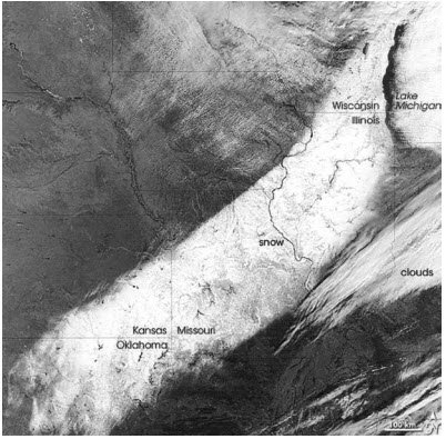
Polar-orbiting satellite image of the snowfield. The image above is courtesy of the University of Illinois.
2017: Several waterspouts formed off the coast of San Remo in northwest Italy. One waterspout moved ashore and caused damage in town. Click HERE for pictures from the website, Severe Weather Europe.
Forecast Discussion
Quite the temperature gradient across southern Michigan early
this morning as cloud cover associated with a precip shield to
our southwest drapes over areas south of I-96/69. Areas under
cloud cover have stayed in the 40s while clear areas further north
are now in the low to mid 20s. Patchy radiational fog has
developed in the colder areas further north and with temps below
freezing some of that fog may freeze on surfaces resulting in
slick spots this morning.

These warmer temperatures will play a slight hand in limiting
overall accumulating snow potential today. Snow is still expected
north of I-96 with the best chances near the M-57 corridor.
Impacts will be generally limited as surface temperatures near to
above freezing curb actual accumulations to around 1 inch. The
main impacts will be a result of periodic mesoscale banding
bringing occasional heavier bursts of snow this morning between
8am to noon. Therefore, some slushy accumulations will be
possible at times along with reduced visibility. Still, mild
temperatures mean overall impacts will be minimal so we will
continue with the thinking of not issuing a Winter Weather
Advisory at this time.

Precipitation will lighten up this afternoon, then a secondary
shortwave will bring a surge of light snow overnight tonight into
Saturday morning. An additional 1 to 2 inches will be possible with
the higher amounts near and north of M-20.

The long term begins Saturday night with another in what by that
point will have been a series of upper waves to move through the
Southern Great Lakes region. Both the ECWMF and the GFS traverse an
upper shortwave trough through the area with the GFS being a bit
more amplified and with a closer track to our area. The ECMWF seems
to be trending towards the GFS so we will follow the GFS with higher
pops (80-90 pct) into our area. Similar temperature stratification
should be in place north to south as well, so we are expecting a
mainly cold rain in the south with a wet snow / rain mix to the
north over Central Lower Michigan. With a slightly more southerly
track in the ECWMF that would put more snow through the bulk of the
forecast area. We may be looking at light accumulations of 1-3
inches on Sunday. Location of that band of snow is still in
question. The precipitation tapers off Sunday night as the system
pulls away to the east.

A clipper system will move in from the northwest on Tuesday which
will continue an overall active 7 day forecast. Marginal
temperatures will once again yield a light mix of rain and snow.
This system looks a bit weaker and should not produce significant
impacts either. Another system will be moving into the area on
Thursday with a warm front lifting north into the state. Marginal
temperatures once again (850mb temps near zero C and surface temps
in the 30s F) will bring about another mix of rain and snow.
It is still snowing! Incredible storm!
We are getting pummeled with snow again! 1.2 inches and counting. I shoveled the driveway already! Too bad for GR, but just go about 10 to 12 miles North for plenty of snow!!!!
Winter wonderland baby!
Not even a flake here today, just an all day rain. Looks like GR is pretty much reporting the same with a third of an inch of rain. The snow deficit continues to grow….
Currently in Lowell where it is snowing currently. Let the good times roll!
Rock n roll that is! Nothing better than snow in December!
About an inch of snow already and still snowing! Incredible!
Moderate to heavy snow as we speak! The roads are already worse than they were earlier this week! What a week of winter weather! Wow!
Let it rain, let it rain! Feel bad for the ski resorts trying to get up and running but the next 10 days do not look promising.
Get ready for the ever popular “special weather statement”
Breaking News>><<< we are getting pummeled with snow and it is sticking to the road! Accumulating snow and cold! Who would have thought?
Temps near freezing with rain is the most horrendous type of weather. Soaks your cloths and makes you even more cold. Snow is much better.
You know it! Rock on Kyle!
33 with rain at my house currently. Seeing reports north of me of some snow.
Always nice to start out the first day of met Winter with a good soaking rain, set the tone for the season. And for November it looks like we only managed about 25% of our average snowfall, another great start to this short season.
Let it Snow, let it Snow, let it Snow!
Just think winter starts in about three weeks! It could be wild!
I love it! November ended with below normal temps!!! Despite some people constantly telling us it was above normal! Funny how facts keep getting in the way of the warm weather hype! Incredible but not surprising! This has been happening all year! Wow, just wow, WOW!!!!
I don’t have all the sunlight stats, but GR had 45% of possible sunshine up to November 28th. Which is much higher than usual… some years we struggle with 20%.
Otherwise seemed like a pretty typical November with variable snowfall
Agreed. Most areas were within one degree of average temp so as you said, a typical November. GR and Lansing did not get much snow at all — 1.9″ and 0.5″, respectively. However some isolated areas received a decent amount.
How did I not know that Canadian professional football is older than the NFL? The first Grey Cup was played eight years prior to the start of the NFL.
The more you know….
Welcome to December and the start of meteorological winter. The November mean at Grand Rapids was 39.7 that is a departure of -0.3 the high for the month was 66 on the 16th and the low was 18 on the 25th and 28th there was 1.67” of total precipitation 3.10 is average. There was 1.8” of snowfall 7.1” is average. At Lansing the mean was 39.1 for a departure of -04. There was 2.04” of precipitation 2.46 is average there. The official snowfall is not complete yet there.
Slim
The official H/L at Grand Rapids yesterday was 51/26 there was no precipitation the sun was out 78% of the time. The highest wind gust was 32MPH out of the SW. For today the average H/L is 41/28 the record high of 65 was set in 1970 the record low of 6 was set in 1976. The wettest December 1st was in 2006 when 0.86” fell as 2.4” of snow fall. The most snowfall of 5” was in 2010 the most snow on the ground is 10” in 1940. Last year the H/L was 36/26 and there was a trace… Read more »
Welcome back to Ellen to TV8 forecast center with baby Piper helping out with the forecast.