When I was a young kid growing up in Bay City area each year we used to listen to and watch the Flint radio and TV stations and each year there was always a reminder of the big Coldwater Road tornado. The Flint stations called it the Coldwater Beecher tornado.
One of the nation’s most devastating natural disasters occurred in the Flint, Michigan’s Beecher district on Monday, June 8th, 1953, resulting in 116 deaths and injuring 844. In a 2000 National Weather Service poll, both the general public, and area “weather experts” voted the Flint-Beecher Tornado as the worst natural disaster in the state of Michigan in the 20th century. This was the deadliest tornado in Michigan history and the 10th deadliest in United States history. The tornado was one of eight tornadoes that touched down the same day in eastern lower Michigan and northwest Ohio. Just prior to the tornado touching down eyewitness accounts recalled that an approaching thunderstorm with several intense lightning strikes turned the northwest sky a dark “black-yellow-green” color. Flint observations that evening recorded a temperature of 78 °F with a dew point of 71 °F and a barometric pressure reading that fell to 28.89. Surface map analysis showed a frontal system associated with a strong low pressure moving west across lower Michigan.
At approximately 8:30 p.m. the tornado touched down near the intersection of Webster and Coldwater Roads. The tornado resulted in 116 fatalities and 844 injuries There were 340 homes completely destroyed, 107 had major damage and another 153 had relatively minor damage. It was half a mile wide. It stayed on the ground for 27 miles. The forward speed of the tornado was 35 mph. The only other F5 tornado in Michigan history was the Hudsonville-Standale Tornado of April 3, 1956. The last F4 tornado in Michigan was the Kalamazoo County to Eaton County twister of April 2, 1977. The weather on June 8th 1953 in southern lower Michigan the H/L at Flint that day was 82/49 with just 0.07” of rain. To the north at Saginaw it was 86/48 with just 0.06” of rain to the south at Detroit it was 83/53 with 0.05” of rain. In our area the H/L here in Grand Rapids was 85/56 with 0.28” of rain and in Lansing it was 82/54 and 0.30” of rain so it looks like there was more rain here in west Michigan from the storms than to the east.
The official H/L yesterday was 71/56 there was a trace of rainfall it was yet another windy day with the highest wind of 43 MPH out of the W. There was 59% of possible sunshine. For today the average H/L is 78/56 the record high of 97 was set in 1933 the record low of 38 was set in 1949 and 1998. The coldest high of 58 was set in 1924 and the warmest low of 75 was set in 2011. The record rainfall of 2.32” fell in 1974. Last year the H/L was 77/40.
We now have 7 days in the record books for June 2024 and the mean so far is 67.5 for a departure of +1.8. the highest so far is 84 and the lowest so far is 52 (note I have 50 at the current time) The total rainfall of just 0.42” is a departure of -0.50”
AREA FORECAST DISCUSSION
NATIONAL WEATHER SERVICE GRAND RAPIDS MI
253 AM EDT SAT JUN 8 2024
KEY MESSAGES
– SHOWERS TODAY, BREEZY SUNDAY
– RISK FOR SOME THUNDERSTORMS THURSDAY EVENING
DISCUSSION
ISSUED AT 251 AM EDT SAT JUN 8 2024
– SHOWERS TODAY, BREEZY SUNDAY
PRESENTLY, SHORTWAVE RIDGING IS KEEPING THE AREA DRY AND CLEAR
CAUSING TEMPS TO FALL INTO THE 50S. HOWEVER, RAIN SHOWERS ARE
BEGINNING TO DEVELOP ACROSS THE NORTHERN MISSISSIPPI RIVER VALLEY
THANKS TO A 700MB SHORTWAVE. THESE WILL CONTINUE TO DEVELOP AND
SPREAD SOUTHEASTWARD INTO WEST MICHIGAN STARTING ACROSS CENTRAL
LOWER THIS MORNING AND EXPANDING SOUTH THROUGH THE DAY. GIVEN LIS
STAYING POSITIVE TODAY INTO TONIGHT AND LITTLE TO NO MUCAPE HAVE
REMOVED THUNDER FROM THE FORECAST. HREF LPMM PROGS SUGGEST 0.25″-
0.5″ IS POSSIBLE NORTH OF I96 WHILE LESS IS EXPECTED SOUTH. SHOWERS
WIND DOWN BY 2AM AS THE MID-LEVEL WAVE EXITS THE AREA.
SUNDAY WILL BE GENERALLY DRY. A WEAK SHORTWAVE CROSSES THROUGH THE
AREA IN THE AFTERNOON CAUSING INCREASED CLOUDS ESPECIALLY NORTH OF
I96. AN ISOLATED SHOWER CANNOT BE RULED OUT, HOWEVER ANY COVERAGE
WOULD BE TO LOW TO JUSTIFY ANY POPS IN THE FORECAST AT PRESENT. A 20-
35 KNOT LLJ MOVES OVERHEAD SUNDAY, AND WHEN COMBINED WITH MIXING
HEIGHTS CLIMBING TO OVER 5KFT GUSTS OF 20-30 MPH ARE POSSIBLE. HIGHS
TODAY AND SUNDAY WILL GENERALLY BE FROM THE UPPER 60S TO MID 70S.
– RISK FOR SOME THUNDERSTORMS THURSDAY EVENING
MODELS ARE ADVERTISING A COLD FRONT DROPPING DOWN FROM THE NORTHWEST
DURING THIS TIME. ZONAL FLOW OUT AHEAD OF THIS FEATURE DRAWS IN AN
UNSTABLE AIR MASS INTO THE CWA DURING THE AFTERNOON/EVENING. A LOW
LEVEL JET IS SHOWN TO STRENGTHEN OVER MI AS THIS FRONT MOVES IN.
ALSO, A MID LEVEL JET STREAK OF 50 TO 70 KNOTS MOVES IN WHICH WILL
LEAD TO STRONGER DEEP LAYER SHEAR. HOWEVER THE LIMITING PARAMETER
FOR ORGANIZED CONVECTION IS THE INSTABILITY WITH ENSEMBLE SURFACE
BASED CAPE VALUES SHOWN TO REMAIN WELL UNDER 1000 J/KG. IF THE
INSTABILITY TRENDS UPWARD WITH TIME, WE COULD END UP WITH STRONGER
STORMS, WHICH WILL NEED TO BE MONITORED. FOR NOW, WE WILL FEATURE
CHANCE POPS IN THE FORECAST FOR THURSDAY EVENING, WHICH IS SUPPORTED
BY THE LATEST ENSEMBLE QPF TRENDS.
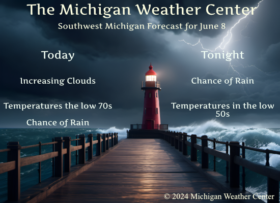
Detailed Forecast for Grand Rapids
Today
Showers likely, mainly after 5pm. Increasing clouds, with a high near 72. Southwest wind 5 to 9 mph becoming northwest in the afternoon. Chance of precipitation is 60%. New precipitation amounts of less than a tenth of an inch possible.
Tonight
Showers likely, mainly before 11pm. Cloudy, then gradually becoming partly cloudy, with a low around 53. West wind 3 to 5 mph. Chance of precipitation is 60%. New precipitation amounts between a tenth and quarter of an inch possible.
Sunday
Mostly sunny, with a high near 73. West wind 7 to 16 mph, with gusts as high as 29 mph.
Sunday Night
Partly cloudy, with a low around 49. North northwest wind 6 to 11 mph, with gusts as high as 24 mph.
Monday
Sunny, with a high near 71. North northwest wind 7 to 9 mph, with gusts as high as 21 mph.
Monday Night
Mostly clear, with a low around 46.
Tuesday
Mostly sunny, with a high near 75.
Tuesday Night
Mostly cloudy, with a low around 57.
Wednesday
Mostly sunny, with a high near 80.
Wednesday Night
Partly cloudy, with a low around 61.
Thursday
Mostly sunny, with a high near 84.
Thursday Night
A chance of showers and thunderstorms. Partly cloudy, with a low around 63.
Friday
A chance of showers and thunderstorms. Mostly sunny, with a high near 82.
Cloudy and cool outside for mid June standers Love it!! No big heat waves in sight priceless…INDY
Rock on Indy! Who would want 90’s with humidity? Keep it rocking!
Hoodies and pants priceless…INDY
Yes, temps in the 50’s with light rain and yet we constantly hear warm weather hype! Incredible!
Under the rock for now they will be back when it’s 75 and funny saying it’s hot outside 😆 INDY
On this day in 2008:
https://www.weather.gov/grr/summary20080608
Radar loop from the link:
I remember this! It was the last day of 4th grade for me and it was the windiest I’ve ever seen it at my house
What a terrible day in Flint 70 years ago. I’m glad for the peaceful weather we have today.
Another picture perfect morning. I hope we get some decent rain tonight. The next week looks to be dry with lots of sun and temps in the 70s and 80s.
I’m certainly enjoying this weather. It’s been pretty good since the end of February for Michigan standards… I would happily take this any year. Maybe the best spring ever?
You will be seeing VERY little rain tonight! Mark it down!
Very cool June! WOW, just wow, WOW!!!!
We have a graduation to go to in the Bay City area so it will off to Linwood later this morning. With a current temperature both here and at the airport of 50 this is the coldest so far this June. At this time it is clear and I have that reading of 50 there was no rainfall here yesterday or overnight.
Slim