Yesterday we had 74° for a high temperature after a low of 59°. We had wind gusts of up to 47 mph with a trace of rain to report.
Weather History
1958: One of the coolest Junes on record saw scattered frost across the region as the temperature fell to the mid-30s.
1996: A weak, short-lived tornado moved through open country east of Lake Lansing in rural Ingham County. Two other small, weak tornadoes struck near Novi and Flint.
On June 7, 1930, the temperature rose to only 54 degrees in Detroit!
1692: A massive earthquake strikes Port Royal in Jamaica, killing some 3,000 people. Click HERE for more information from the History Channel.
1816: The following is found on page 31, from the book, “History of the American Clock Business for the Past Sixty Years, and Life of Chauncey Jerome,” written by Chauncey Jerome. The book was published in 1860. “The next summer was a cold one of 1816, which none of the old people will ever forget, and which many of the young have heard a great deal about. There was ice and snow in every month of the year. I well remember on the seventh of June, while on my way to work, about a mile from home, dressed throughout with thick woolen clothes and an overcoat on, my hands got so cold that I was obliged to lay down my tools and put on a pair of mittens which I had in my pocket. It snowed about an hour that day.” This bitter cold event occurred in Plymouth, Connecticut.
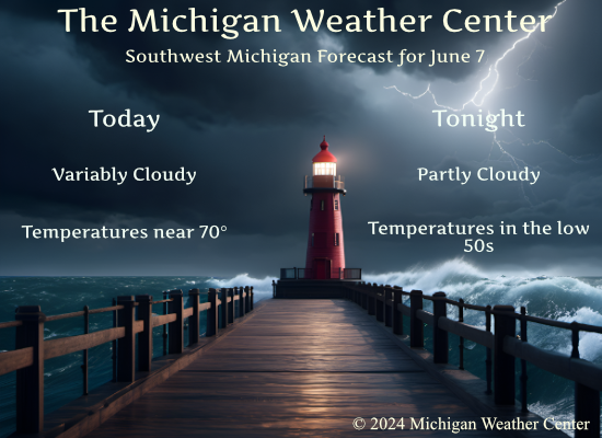
Forecast Discussion
- Breezy Today, Showers This Morning and Saturday

The main driver of our weather through this evening is a deep upper-
low across the region visible on mid-level water vapor imagery. This
low is driving isolated instability driven showers north of I96
which will diminish through the morning as the upper-low pulls away.
The northwest flow will support deeper mixing today, and when
combined with the isallobaric addition to the wind behind the
departing low will make it breezy today. The best winds/gusts will
be near and south of I94 where winds around 20 mph gusting to 30-35
mph (isolated gusts near 40 mph) are expected. Across the northern
CWA winds will be lower around 10-15 gusting to 25 mph. Highs today
will be in the upper 60s to near 70.

Skies clear out tonight as dry air makes its way in along with
surface and upper-level ridging with lows around 50. Near
daybreak Saturday, showers will arrive north of M46 as a
shortwave tracks into the area. They then expand during the
afternoon across the rest of the area. Highest QPF of 0.25-0.5"
will be north of I96 due to deformation on the north side of the
surface reflection, with up to 0.25" south. As 850mb temps climb
above 10C Sunday, highs climb back into the low 70s.

- Diminishing Showers Saturday Evening

A 700 mb trough is advertised by most models to shift through the
CWA Saturday evening.  Forecast soundings show fairly saturated
conditions through 500 mb with some lift noted in Bufkit overviews.
As a result, we will bump up the POPs for Saturday evening across
the CWA to account for the passage of this feature. The atmosphere
is shown to dry out on the backside of this system so after 06z
Sunday we will feature mainly dry conditions.

- Monday looks like the coolest day next week

Models are advertising fairly significant 850 mb temperature
anomalies on Monday.  Ensemble surface max temperatures have trended
downward.  Deterministic values and ensemble values suggest we will
struggle to reach 70 degrees as the 850 mb thermal trough tracks
through. We will nudge the max temperatures slightly downward for
Monday and feature most locations topping out in the 60`s.

- Still looks like a warmup for the end of the week but it trending
more toward a gradual temperature increase

Previous runs of the Canadian model have featured hot weather
arriving by Thursday, but the 00z run has trended a degree or two
lower.  The ECMWF has trended up with the temperatures slightly
Thursday and now has values topping 80 degrees, while the GFS is
showing 70`s then. Blending the values suggest we may struggle to
top 85 degrees on Thursday.  Thus I will lower values slightly and
feature most of the CWA in the 80 to 85 degree range, which is still
above normal.
Feels more like Fall than Summer! What a cool pattern! Incredible!
It’s been a warm start to June, and another blowtorch is coming!
Great friday beach day for west Michigan lol!! I say this is a great friday for fishing nothing hot. check out tomorrow’s forcast 3rd Saturday in a roll with cool rain one makes you wonder if we will have another cool cloudy wet summer in the making happy Friday…INDY
As noted in todays weather history June 1958 was one of the coldest on record with a mean of 62.0 here in GR that is a departure of -6.9. Lansing had a mean of 62.7 for a departure of -5.3 Muskegon had a mean of 60.2 for a departure of -7.2.
Slim
The overnight low here in MBY was 57 there was no rainfall overnight. At the current time it is partly cloudy and 58.
Slim
The official H/L yesterday was 75/60 there was 0.05” of rainfall. As has been the case this year it was yet another windy day with the peak gust of 42MPH out of the W. There was 61% of possible sunshine. For today the average H/L is 77/56 the record high of 94 was set in 2011 the record low of 38 was set in 1958. The coldest high was 56 in 1909 and the warmest low was 76 in 1933. The most rainfall of 1.87” fell in 1939 last year the H/L was 77/47.
Slim