
As many of you know I used to live in the great state of Maine in the 70s where we would get great snowmaking noreasters in the winter. Today hurricane Lee is predicted to move towards the state on its journey into far eastern Canada.
maine 9 15Our weather will be much tamer. Milder weather can be expected in the next few days. After a sunny day today, cloud cover will increase for the weekend. Some light rain showers will move through on Saturday night and Sunday. Rainfall amounts will be on the order of less than a quarter inch.
Grand Rapids Forecast
9 15 grrU.S.A and Global Events for September 15th:
1747: Some historical accounts of a hurricane caused flooding on the Rappahannock River in Virginia. A slave ship was overturned, and several fatalities were reported.
1945: A hurricane entered the south Florida coast at Homestead, curving northward right up through the center of Florida, remaining over land, and exited near Jacksonville Beach with winds gusting to 170 mph. The following is from the Homestead Air Reserve Base. “On Sept. 15, 1945, three years to the day after the founding of the Homestead Army Air Field, a massive hurricane roared ashore, sending winds of up to 145 miles per hour tearing through the Air Field’s buildings. Enlisted housing facilities, the nurses’ dormitory, and the Base Exchange were all destroyed. The roof was ripped from what would later become building 741, the Big Hangar. The base laundry and fire station were both declared total losses. The few remaining aircraft were tossed about like leaves.” 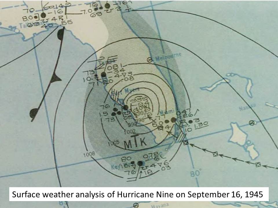
Click HERE for more information from Miami Archives.
2010: The largest hailstone in Kansas was found in southwest Wichita. It measured 7.75 inches in diameter.

The image above is from a tweet by the NWS Office in Wichita, Kansas.
2011: An EF0 Waterspout moved ashore in Ocean City, Maryland. Click HERE for more information from the Capital Weather Gang.
Forecast Discussion
High pressure over Lake Huron remains in control of our weather
today. IR loop shows mostly clear skies with some cirrus floating
overhead. Forecast concerns deal with precipitation chances
Saturday.

For today, though, we`ll see abundant sunshine and slightly warmer
temperatures than we saw yesterday. Generally, lower 70s are
expected. The clear skies will continue this evening before a more
expansive cloud deck approaches after midnight ahead of the next
front.

A developing cold front will track east across Wisconsin Saturday.
Forecast soundings show quite a bit of dry air below 750 mb and
so precipitation development will likely be slow. However, HREF
does show a few hundred joules of CAPE ahead of the front and some
lift will be provided by the front too. Thus, it`s possible we
could see isolated showers by Saturday afternoon. The higher
chance of showers and perhaps a thunderstorm will arrive Saturday
night.

.LONG TERM...(Saturday night through Thursday)
Issued at 358 AM EDT Fri Sep 15 2023

There has not been a lot of change in the long term period with
regard to the evolution of the pattern and sensible weather. We
are still looking at chances for showers and a few thunderstorms
from Saturday evening through Sunday evening otherwise the
forecast is dry Monday through Thursday. As far as the upper
pattern...a trough will be moving through the Great Lakes region
over the weekend, which shifts to a northwest flow on Monday,
becoming zonal on Tuesday with ridging developing for the middle
of the week.

As for the details, the front that traverses the area this weekend
is rather weak. The surface low will be located well north into
Canada and will be filling with time. There will be enough
instability though and at least some convergence to touch off a
few showers and storms. Surface dew points rise to around 60F with
MUCAPE values increasing into the 500-1000 j/kg range on Sunday.
Bottom line there will be some precipitation, but we are not
expecting anything widespread of heavy. Current chances for
precipitation in the forecast are on the order of 30-60 percent
this weekend.

Dry weather should then occur from later Sunday evening through
Thursday with no major systems moving through the region. At the
surface a ridge will be in place early in the work week giving way
to southwest flow.

A warming trend will be noted as we work from the weekend through
the work week. Highs on Sunday will be in the 60s, rising to 80 by
Wednesday and Thursday.
Below normal temps – day after day after day! A truly incredible stretch of weather! Wow!!!
It’s been a dry few weeks at my home. Most storms have been missing us. Maybe 1” in the last 3+ weeks. Farmers have been running the pivots to get the last of the moisture to their beans.
Drove past the 1-96 tornado damage yesterday. Hundreds of trees “shredded” and traffic still backed up. Saw lots of crews working too
Yeah the tree damage over there is unbelievable. It was a very wide tornado. Idk if you happen to have caught it but along 96 just west of Kent Street (one of the 2 Portland exits) this is an entire chunk of woods that is shredded as well with only a handful of trees even standing. Looks like tornado damage to me as it matches rotation on radar but I can’t say 100%. NWS GR did not comment when I asked them about it.
I’ll check it out again on Sunday when I head back home. I can definitely see why motorists cars got flipped over
Still have the sounds of chainsaws in the air even 3 weeks after the destructive storms. There are still many trees down left to be cleaned up in my area. Portland State Game Area is still not able to be accessed my vehicle due to extensive damage.
It was a cold 42 for a low temp last night at my house. As stated yesterday I live in a bit of a cold pocket so I can come in a good 5 degrees colder than others. I am up one in the past hour to 43.
Today should be sunny before becoming cloudy over the weekend. There is around a 50% chance of showers on Saturday night and into Sunday. Highs will be in the low 70’s today and tomorrow before dropping into the 60’s for Sunday and Monday. It could warm up to near 80 by Wednesday of next week. Lows will range from the mid 40’s to the upper 50’s
Slim
Yesterday was a pleasant mid-September day with an official H/L of 71/46. There was no rain fall and the sun was out 82% of the possible time. The highest wind speed was just 10 MPH out of the W. For today the average H/L is now down to 74/53. The record high of 97 was set in 1939 and the record low of 36 was set in 1953. The record rain fall amount of 1.32” fell in 1901. Last year the H/L was 77/54.
Slim