
Patchy early morning fog is expected. In some areas, the fog could be locally dense with limited visibility. By mid-morning, fog should have burned off, and we can expect mostly sunny skies for the rest of the day. Highs will be in the upper 60s to around 70 today with light and variable winds anticipated. Another system will slowly cross the Upper Midwest into the Great Lakes by Friday night into Saturday. This looks to be a slow-moving system, though not much in the way of rain is expected at this time. A few rumbles of thunder are possible Saturday, and perhaps again Sunday afternoon as the front slowly moves through. Looking forward the CPC is guessing warmer than normal temperatures and drier conditions for the state.

Grand Rapids Forecast
grr 9 14U.S.A and Global Events for September 14th:
1928: A violent, estimated F4 tornado, with winds of 200 mph, tore across Rockford, Illinois. The tornado first touched down 8 miles south-southwest of Rockford and moved across the southeast part of the city. The tornado was on the ground for 25 miles with a width varying from 200 to 500 feet. A total of 14 people were killed, with around 100 injuries reported in Rockford alone. Two hundred buildings were damaged or destroyed. Click HERE for a vimeo.com video.
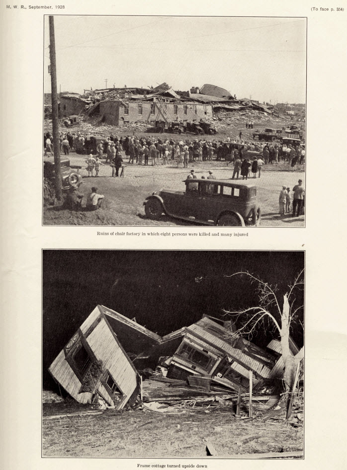
The image above is from the Monthly Weather Review published in September 1928.
1977: Severe thunderstorms produced several tornadoes in eastern Arkansas, killing one. Click HERE for a tweet by the NWS Office in Little Rock, Arkansas.
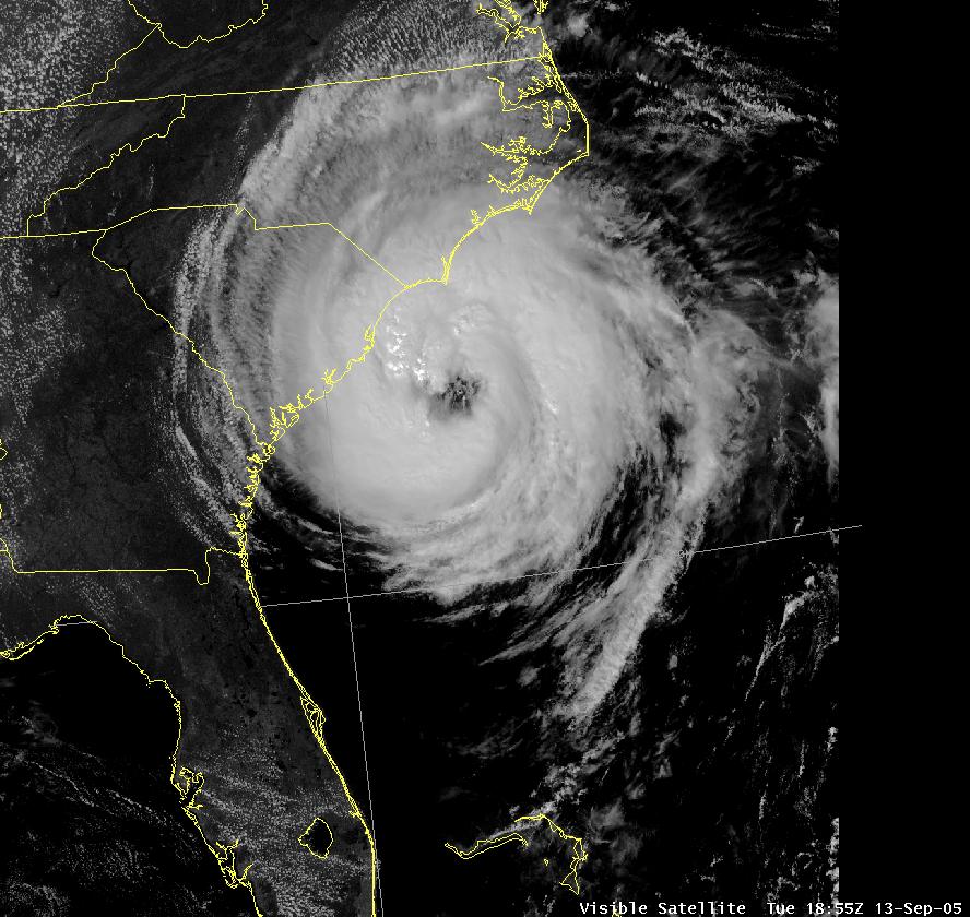
2005: Hurricane Ophelia caused some damage and beach erosion along the United States coastline from Florida to North Carolina. The closest approach occurred on September 14 and 15 with its western eyewall crossing land and the eye remaining just offshore in the Carolinas.
2008: Hurricane Ike became extratropical on this day. The St. Louis Metropolitan Area experienced hurricane conditions, with Ike’s remnants inflicting severe damage to homes. Several areas in Illinois and Indiana, already flooded by the frontal boundary to the north, saw significant additional rainfall. Due to flooding in Chicago, a state of emergency was declared for Cook County due to flooding of the Des Plaines River. Hurricane-force wind gusts were reported to the east of the center across parts of Kentucky, Indiana, Ohio, and Pennsylvania with significant wind damage including structural damage to buildings and trees.
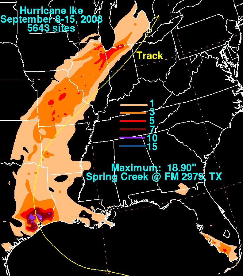
Storm total rainfall map of Hurricane Ike during September 2008. The image is courtesy of the Weather Prediction Center.
Forecast Discussion
Temperatures are chilly early this morning over the northern cwa.
Leota is currently at 35 degrees. Most other readings are in the
40s. The Frost Advisory will remain in effect until 8 am.

High pressure will be overhead today and begin drifting east
tonight and Friday. Sunny skies are expected today and Friday with
clear skies tonight. Highs in the mid to upper 60s are expected
today and a few degrees warmer Friday.

Lows tonight will fall into the 40s again under good radiational
conditions. Look for lows in the upper 30s to lower 40s near US-10
and mid 40s elsewhere. Similar to today, some patchy fog is
possible in low lying areas.

-- Limited chances for precipitation in the long term --

The only real chance for precipitation during the long term period
is during the Saturday through Sunday time frame. Southwest flow
aloft will be in place to begin the period Friday night continuing
into Saturday. An upper trough in the Northern Plains during this
time will begin to push into Lower Michigan on Saturday. The first
chances for a few rain showers will occur on Saturday across Central
Lower Michigan. A small chance for a thunderstorm or two exists on
Saturday as MUCAPE values try to approach 500 J/KG or so. Certainly
not a lot of instability, but maybe just enough for a few rumbles.
Our pops on Saturday are small across Central Lower Michigan, 20-30
percent. The best chances for showers and a few thunderstorms will
come Saturday night into Sunday when the surface cold front
associated with the upper wave is moving through. We have 30-50
percent pops in the forecast during this time frame. Instability
fades a bit Saturday night, but returns on Sunday. Sunday will
likely be the best chance for a few storms during the long term
period as MUCAPE rises to around 1,000 J/KG. Dry weather is then
forecast for the remainder of the long term from Sunday night all
the way through next Thursday. Upper ridging gradually builds into
the Great Lakes region for the middle of next week.

-- Temperatures warming into the middle of next week --

Temperatures will be near normal on Saturday in a southwest flow at
the surface. Highs will likely top out in many areas in the lower
70s. A cold front moving through on Sunday will bring clouds and
precipitation that keep temperatures down a bit and below normal in
the 60s. A warming trend begins from there with highs pushing into
the upper 70s or near 80 for next Wednesday and Thursday. Both the 6-
10 day and 8-14 day temperature forecasts from CPC are showing above
normal readings for our area. Much above normal heights are seen
with either ridging or deep southwest flow in place aloft towards
the end of next week.
Losing 3 minutes of daylight now before we know it when 7pm rolls around it will be dark outdoors love it!! Mader down to 44 out in my hood early this morning great bonf fire weather… INDY Fall!!
It got down to a very chilly 39 last night at my house. Coldest night in quite some time. I’m in a bit of a colder area than surrounding areas so overnight lows can come in colder than surrounding areas at my place.
Wow! I love it!
A lot of pics and a satellite pic of the tornado scar a couple weeks ago in Ingram county:
https://www.mlive.com/news/2023/09/satellite-images-show-tornado-scar-cutting-across-mid-michigan-after-twister-outbreak.html
Wow, I was amazed by the one with the 2×4 that was stuck in the car tire.
Slim
This is a repost from yesterday. I know that there has been an ongoing dispute with the departures from average for Grand Rapids and several other locations in SW Michigan. I asked for information on this issue to both the NWS Grand Rapids and the NCEI. I received a rapid response from both. I will post their responses on my Saturday post.
Slim
The official H/L yesterday at Grand Rapids was 65/48, there was no rain fall. The sun was out 46% of the possible time. There were 8 HDD’s There was not much wind with the highest wind speed of just 12MPH out of the N. For today the average H/L is now down to 75/54. The record high of 95 was in 1939 the record low of 31 was way back in 1899. The record rain fall of 2.15” fell in 1993. Last year the H/L was 78/53. The week ahead looks to start off on the cool side with a… Read more »
It certainly feels like autumn this morning. 44 with just a bit of fog when I took our Daisy outside this morning. We’re in the midst of some really nice, pleasant weather.
Have a great day, friends.