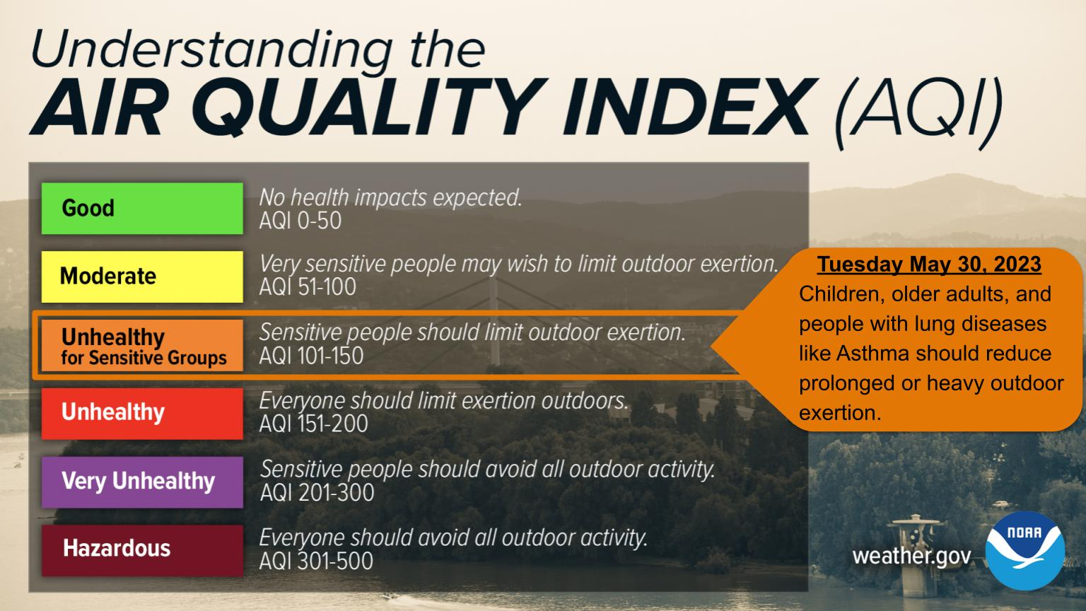
...Air Quality Alert for Tuesday, May 30...

The Michigan Department of Environment, Great Lakes, and Energy
has declared Tuesday, May 30 to be an Action Day for elevated levels
of ozone. Pollutants are expected to be in the unhealthy for
sensitive groups range.

The Action Day is in effect for the following Michigan counties...

Van Buren, Allegan, Ottawa, Kent, Muskegon, Oceana, and Mason

People and businesses are urged to avoid activities which lead
to ozone formation. These activities include refueling vehicles
or topping off when refueling, using gasoline powered lawn
equipment, and using charcoal lighter fluid. Positive activities
include car pooling, biking to work, delaying or combining
errands, and using water based paints.

It is recommended that active children and adults, and persons
with respiratory diseases such as asthma, limit prolonged
outdoor exertion.

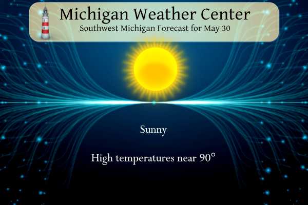
Temperatures will be running much warmer than average this week, with the mid-80s to lower 90s for highs. The air will be dramatically cooler at the beaches of Lake Michigan, where water temperatures are still in the 50s. There will only be slim chances for isolated rain showers mainly due to a lake breeze setting up along US 131.
U.S.A and Global Events for May 30th:
1879: A significant outbreak of severe weather occurred in Kansas and western Missouri. In Kansas, tornadoes killed eighteen persons at Delphos and thirty persons at Irving. Two tornadoes struck the town of Irving within a few minutes time virtually wiping the small Kansas community off the map. The second tornado was perhaps two miles wide and exhibited multiple vortices.
1927: The Kentucky River peaks during a massive flood that killed 89 people and left thousands homeless. Torrential rains caused this unprecedented flood.
1988: Memorial Day heralded heavy snow in some of the mountains and higher passes of Wyoming, closing roads in Yellowstone Park. McDonald Pass, Montana was blanketed with eight inches of snow, while the temperature at Miles City, Montana soared to 94 degrees.
Grand Rapids Forecast
5 30 grrHolland Beach Forecast
5 30 holForecast Discussion
- Small risk for a brief afternoon shower or thunderstorm into Wed

Moisture will only slowly increase today with PWAT values
potentially reaching around an inch during the afternoon. Given
the very warm conditions, this is not a lot of moisture to work
with. Very weak instability tries to develop this afternoon but a
better shot for instability exists for Wednesday afternoon. Weak
low level convergence develops along the lake breeze this
afternoon, roughly along US 131. If a shower did develop this
afternoon, this would be the general area. Given the very limited
moisture around, the coverage is too low to include precipitation
in the forecast for this afternoon. This is also supported by
ensemble trends in qpf potential, which are decreasing with each
run. For Wednesday afternoon, its kind of a similar setup but with
a little more PWAT and instability to work with. Lifted index
values are progged to peak at -2 to -4 deg C especially toward the
Manistee National Forest area. Some models like the NAM show
greater instability Wednesday, but those models are showing
surface dewpoints climbing into the upper 60s, which appears a
least several degrees to high. The current surface plot does not
show such high dewpoint values anywhere near MI. So, with only
limited moisture available to work with any shower/storm that does
form will have to compete with other cells trying to form for
this limited moisture. As a result, it appears the coverage will
be widely scattered at best.

- Continued very warm with low afternoon humidity levels into Wed

Many areas made it into the mid 80s on Monday. We will start
today off several degrees higher as compared to Monday. Also we
will be advecting some warmer air at 925/850 mb, where values
climb a degree or two compared to Mondays temperatures. As a
result both Tuesday and Wednesday will be warmer than Monday. We
will continue to feature max temperatures in the upper 80s both
days and a few locations could hit 90 degrees. The immediate
lakeshore region will be at least 10 degrees lower with the
afternoon temperatures as compared to inland locations. Afternoon
humidity levels are still expected to drop down below 30 percent
away from Lake Michigan today but humidity values may end up in
the 30 to 35 percent range Wednesday as the moisture gradually
increases. Fortunately the wind will be relatively weak,
remaining under 15 mph most of the time into Wednesday. As with
previous days, a lake breeze will likely develop each afternoon
and potentially move inland to around US 131. The winds will shift
around this front.

.LONG TERM...(Wednesday night through Monday)
Issued at 226 AM EDT Tue May 30 2023

Retrograding upper-level high over the Great Lakes region through
the end of the week supports much warmer-than-normal temperatures,
potentially an early season heat wave, with limited chances for rain
showers. Late in the week, the strengthening high over south-central
Canada and digging trough over Quebec may send a backdoor cold front
through Lower Michigan around Sun/Mon, providing some relief from
the heat... though ensembles are still diverging appreciably with
the magnitude and longevity of this reprieve.

The warmest days and greatest chances for 90-degree temperatures
appear to be Thu, Fri, and Sat. Fortunately the afternoon dew points
will generally be in the 50s or no more than the lower 60s,
especially as a pocket of drier air advects in from the east on Fri.
Relative humidity dropping into the 30s or 20s percent during the
day will keep heat index values close to the air temperature.
Wildland fire concerns especially in conifer forests will remain
increased as fuel moisture is extremely low, though one positive is
that winds will often be just a light breeze. As has been happening
the past several days, despite the broad-scale winds with an
easterly component, the daytime lake breeze will keep places near
Lake Michigan cooler.

Rain chances from Thu to Sat are barely worth a slight chance (20
percent) mention mainly in central Michigan where somewhat higher
moisture is favored to be. A number of factors are working against
the odds of appreciable rain over a large area, including a mid-
level subsidence inversion, dry air entrainment into clouds, dry air
beneath clouds, and weak vertical wind shear. More widespread but
still slight chance of rain is being mentioned for the backdoor cold
front early next week.

For perspective, looking at 130-year records of daily wx obs at
Grand Rapids, Lansing, Kalamazoo, and Battle Creek, about 14-27
percent of years have a 90 degree day by June 5, and only 6-15
percent of years have 3+ days of 90 degrees by June,
I see the CPC is trending much cooler! Fantastic news! Who in their right mind would want temps in the 90’s? Incredible!
I see low 70’s in parts of MI! Wow, just!
I see 90’s in Michigan! And it’s only going to get hotter this week.
Some info from Bill: “In Gr. Rapids we’ve had only 2 days that have reached 100° since 1964. Those were July 5th and 6th in 2012 with highs of 101° and 104°. In 2012, G.R. had only 0.03″ of rain from June 22 – July 17.” It’s hard to forget the summer of 2012. By far the most extreme summer of my lifetime. I went up to Tahquomenon Falls for rhe 4th of July that year and watched fireworks in Paradise. Our afternoons at the superior shoreline were only in the 60s/low 70s. Lake Superior was actually tolerable to swim… Read more »
It was 1988 for me. We had nearly 40 days in the 90s. We may have hit 100 once or twice. Shoot, even Houghton/Hancock had a 102 temp that summer. It was hot all summer long. Very little rain too.
Both 1988 and 2012 were among the hottest here in Michigan. 1988 had more days of 90 or better but the mean temperatures were higher in 2012. In 1988 there was a sharp cut off of the heat on August 17th with a line of strong thunderstorms that dropped almost due south across the state.
Slim
Yea 2012 is definitely the worst summer I remember! Along with 2009- it was a very chilly summer and I was on the outdoor swim team
Just got back from a outside walk. It is hot in the sun but not too bad in the shade. In fact the temperature here in MBY is 88 but with a Dew Point of 54 the Heat Index is at 86.
Slim
It feels great in the shade, the sun gets hot after a few minutes. It really is not that bad with the low dew point… 88 with a high dew point would be a different story
Ok… Not a weather question… Need some help.. friends with dogs what do you use to keep them in your yard…fence, under ground fence, gps collar or ??? Any advice…
Weather note… My irises are so beautiful… I wish they would stay longer. I am having to water them every night.
We have invisible fence at our house. We trained our golden retriever on it to stay in the yard and he no longer leaves the yard anymore. He knows right where the lot lines are and does not cross. Works great. We have a very large backyard so he has lots of room to roam
We have used PetSafe for years and we’re very happy with it. It has a 100-foot radius from the plug-in unit. It’s just the unit and the collar. No digging needed. The cool thing is that it’s pretty much portable and have taken it with us on vacation.
https://www.chewy.com/petsafe-stay-play-wireless-fence/dp/140692?utm_source=google-product&utm_medium=cpc&utm_campaign=12646124820&utm_content=PetSafe&utm_term=&gclid=CjwKCAjwvdajBhBEEiwAeMh1U4Fochtx9NeeJXEImObjfpD_UtyA7lfop3qi_kYBeFQNd0VTYcsGXBoCvXwQAvD_BwE
Thanks… I so appreciate it.. I was looking at both of those.
86 and feels hot already at midday. The grass is really getting crunchy – even with watering. I am becoming concerned for the farmers. 🙁
Yes..we mowed middle of last week… Now crunchy…
Here in MBY the air temperature is now 88 the Dew Point is 54 for a heat index of 86. And it is gettin very dry for May. Unless we get some rain tomorrow this will be the 2nd driest May at GR and Muskegon and the 5th driest at Lansing. I am gathering some information on past very dry Mays and how the summer worked out. So far it looks like past dry May’s had a mostly warmer that average summer.
Slim
Wow, NWS has 90, 92, 91. And yet some people on here said no blowtorch was coming. I’m glad I sent out the blowtorch watch last week!
Well the grass is getting brown so I guess that is from the “blowtorch”
Slim
Many locations will get up near 90 this afternoon. I suppose some locations could hit 90. It’s also a Clean air action day. Looks like a hot week ahead with very minimal rain. One has to wonder when widespread rains will return? Pretty significant dry spell.
I think the only reason we are not in an official drought is because we had such a wet start to the year (I think it was a record start for precip?). If this dry weather keep up through June… I’m sure we will be in a drought
MBY hit 91f.
I tossed this up yesterday but I will toss it up again today. Number of days with highs of 90 and 88 or better. May 30th There are 4 of 90 or better last time 1953, highs of 88 or better 12 times last times 2011,2010, 2007 and 2006.. For May 31st 90 or better 5 times last time 1988. For 88 or better 9 times last times 2014 and 2011. For June 1st there was one day of 100 or better (102) 4 days of 90 or better last time 1988 and 7 days of 88 or better last… Read more »
Also of note of the dryness. The chances of rain look very slim for the rest of the month. If there is no rain for the rest of the month this will be the 2nd driest May at Grand Rapids, The 5th driest at Lansing and Muskegon and the 8th driest at Holland. At all locations the years 1936 and 1988 are among the driest and while it is way too early to tell how the summer will play out 1936 had a record heat wave and 1988 was just a over all hot summer. Will that happen this year?… Read more »
Around here the signs of our dry spell have ballooned. Yards are brown and crunchy, it is very dusty, and pond levels are already low. I expect this week will really stress the crops that are already struggling for moisture.
The official H/L yesterday was 86/52 there was no rain fall and there was 92% of possible sunshine. With the lack of rain and all this sunshine it has become very dry. Driving around the area you can see a lot of brown grass. There were no HDD’s yesterday and 4 CDD’s . For today the average H/L is 75/54 the record high of 92 was set in 1919 and the record low of 35 was set in 1965 and 1996. The record rain fall of 1.91” fell in 1989.
Slim
This week looks to be very warm to hot with a very slight chance of rain fall. Highs look to be in the upper 80’s to low 90’s While it is rather uncommon for it to get this warm in late May and the start of June there in only a very small chance of any records being set. The record highs at Grand Rapid for today is 92, For Wednesday it is 95 for Thursday it is 102, for Friday it is 95 and for Saturday it is 96.
Slim