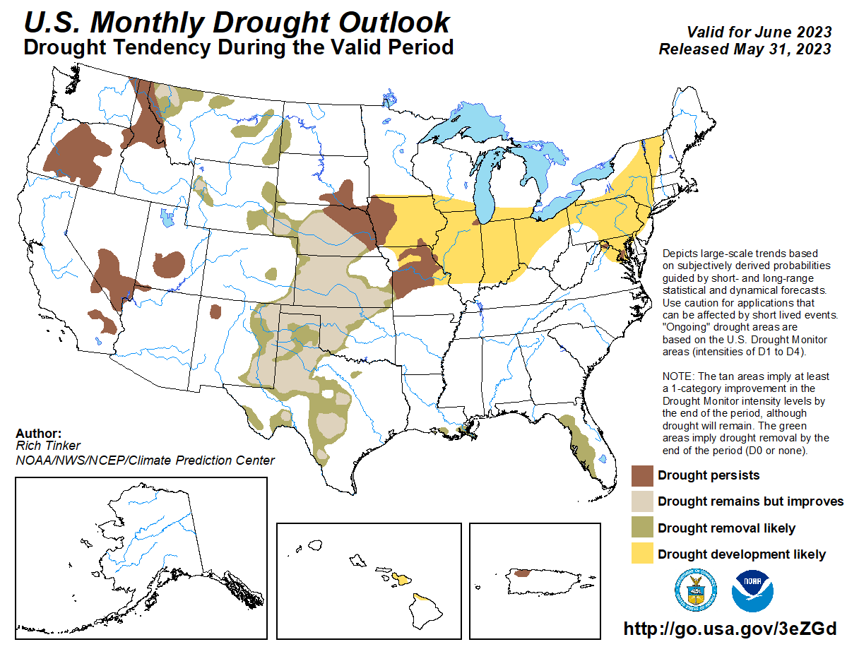
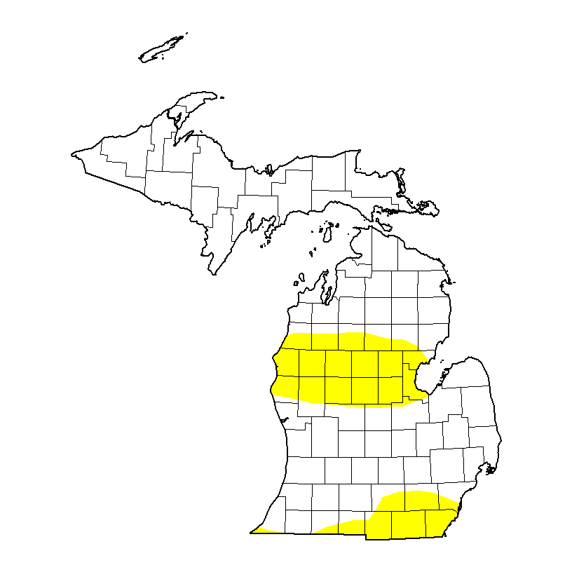
Pop-up showers missed Otsego by five miles to the west yesterday. My wife and I considered doing a rain dance but the neighbors probably wouldn’t like seeing a couple of old folk dancing about the yard. It has been 25 days since we have seen measurable rain in Otsego. The CPC updated forecast for June has changed to above-normal temperatures and below-normal precipitation. The updated drought monitor shows drought conditions will likely continue well into June. The second map shows where drought conditions are currently – I believe it should include all of lower Michigan.
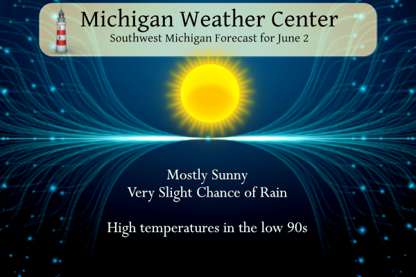
Another hot and dry day is in store for SW Michigan with temperatures soaring back into the low to mid-90s.
Grand Rapids Forecast
6 2 grr...Air Quality Alert for Friday June 2nd... The Michigan Department of Environment, Great Lakes, and Energy has declared Friday June 2nd to be an Action Day for elevated levels of ozone. Pollutants are expected to be in the unhealthy for sensitive groups range. The Action Day is in effect for the following Michigan counties... Mason, Oceana, Muskegon, Ottawa, Kent, Allegan, Van Buren, Kalamazoo, Ionia, Clinton, Barry, Eaton, Ingham, Calhoun, and Jackson. People and businesses are urged to avoid activities which lead to ozone formation. These activities include refueling vehicles or topping off when refueling, using gasoline powered lawn equipment, and using charcoal lighter fluid. Positive activities include car pooling, biking to work, delaying or combining errands, and using water based paints. It is recommended that active children and adults, and persons with respiratory diseases such as asthma, limit prolonged outdoor exertion.
U.S.A and Global Events for June 2nd:
1889: The same storm that caused the historic dam failure in Johnstown, PA, also affected Washington, D.C. The streets and reservations in the center of the city and all the wharves and streets along the riverfront were underwater. Pennsylvania Avenue was flooded from 2nd to 10th Streets. The Potomac River crested at the Aqueduct Bridge at 19.5 feet on June 2. Additionally, damage occurred on Rock Creek, with the Woodley Lane Bridge washed away. Considerable damage occurred to machinery plants and material at the Navy Yard.
1917: The temperature at Tribune, Kansas dipped to 30 degrees to establish a state record for June.
1998: Frostburg, Maryland on June 2, 1998, at 9:45 PM – This was part of a killer outbreak of tornadoes that moved southeast from Pennsylvania. The storm entered Garrett County, Maryland striking the town of Finzel. It then moved up and over Big Savage Mountain in Allegany County and ripped through the northern portion of Frostburg. It reached its peak strength as it crossed the ridge. Winds were estimated between 210 and 250 mph (F4 on the Fujita Tornado Damage Scale). This was the first tornado to “officially” be rated an “F4” in the State of Maryland. The National Weather Service adopted the Fujita Damage Scale in 1973. The total damage path of the Frostburg tornado was over 25 miles long (8 miles in Allegany County) and up to a half-mile wide. Along most of its path, it was producing winds over 125 mph (F2 or stronger). The damage path was continuous as it moved up and down over 2000-foot mountain ridges. The fact that no one was killed in Maryland was attributed to 5 to 10 minutes warning that was well communicated to people in Frostburg over television, radio, scanners, telephones, and sirens. People took quick action to move to their basements. A mother and child rode out the storm as it destroyed their house hiding under a table in the basement. They were shaken but unharmed. A jacket from a Frostburg home was found 25 miles away. A diploma was found near Winchester, Virginia, 60 miles away and a bill was found near Sterling Virginia (about 100 miles away).
Forecast Discussion
.SHORT TERM...(Today through Saturday)
Issued at 317 AM EDT Fri Jun 2 2023

The threat for afternoon convection along the lake breeze does not
look to be present today as has been the case the past few days.
There will be a lake breeze convergence band that forms again today
with the light synoptic wind in place. There will be a couple of
differences that seem to be the limiting factors for convection
forming today.

The first factor will be less low level moisture around to fuel the
better updrafts. We have lower dew points moving in over the eastern
area already. Then, it looks like the higher dew points to the west
will be able to mix out through diurnal heating/mixing today. This
will be in coordination also with a mid level cap that should limit
vertical development today. Mid level temps have warmed slightly,
and the limited low level moisture will not be able to help lift the
parcel past the inversion/cap.

We do get into a scenario on Saturday however that shower and storm
chances will redevelop Saturday afternoon. This increase in rain
chances will be boosted by a weak short wave aloft and associated
weak cold front that will drop down into the area from the NE. These
two features will help to act on higher dew points in the 60s again,
to yield decent instability to the degree of around 1500-2000 J/kg.
The lake breeze convergence band will be there, and be the main
focus for development helped by the incoming front and short wave.

Forecast soundings show shear will continue to be quite weak, less
than 10 knots, that supports more pulse type of storms. One can not
rule out some isolated larger hail with the instability in place,
and mid level lapse rates around 7.0C/km. These will be short lived,
and produce outflows for additional storms to form on. Locally heavy
downpours will also occur under the slow moving storms with
precipitable water values around 1.5 inches.

.LONG TERM...(Saturday night through Thursday)
Issued at 317 AM EDT Fri Jun 2 2023

A deepening positively tilted trough extending from a southward
moving upper level low will force the high pressure that has
dominated the weather pattern for this past week to retrograde
Saturday evening into Sunday. Latest guidance brings a mostly dry
cold front through Lower Michigan mid to late on Saturday with the
slightly cooler air in behind it not advecting into the region until
Sunday. So max temperatures on Sunday will only be around 10 degrees
above normal instead of 15 to 20 degrees above normal.

However, The EC/GEFS is still in fair consensus that as the high
pressure is continually pushed westward, a large upper level low
will move southward across the Northeast and into the Mid Atlantic.
This will bring another cold front through the Great Lakes Monday
into Tuesday. So by Tuesday, temperatures will be back to around
normal which for this time of year is in the mid to upper 70s.

 The instability created by the boundary Monday into Tuesday could
spark some showers and perhaps a thunderstorm given the mid level
thermal advection and pressure gradient, however there remains a
lack of moisture. Given this dichotomy have left low POPS.
Remember to check on your pets and your Neighbors during these times very important also drink lots of water stay in the shade or jump into lake Michigan I prefer a ice cold sprite on a day like this enjoy but be safe INDY
I worked commercial and industrial construction in the 70s, a horrible job in the summer when we were pouring footings and walls. Before that I worked the farm bailing hay 10 to 12 hours a day – builds character
Stay cool too Indy!! Enjoying an Ice Cold Oberon right now!
Feel bad for the guys working at the construction site. All sun, hardly even a breeze, and day after day over 90 degrees. Anyone know when was the last time we had 5 or 6 days in a row over 90?
Read some local reports of inland lakes already having water temps in the 70’s! And it’s only June 2nd!
Back to back to back to back 90+ days!
So glad I issued that blowtorch watch last week when several people on here said no blowtorch was coming.
When you been preaching it since February I haft to agree with them several people!! INDY
We dont get any rain soon we will be seeing dust bowls like the wild west around west Michigan crazzy dry outside!! Helooo weekend the nights been just perfect for cold sprites and bon fires as temps fall quickly after the sets enjoy INDY
Green flags look to fly all weekend at Lake MI. Great time to be at the beach. I’ll be out at Holland State Park this weekend enjoying the lake and sunshine.
Wouldn’t that be funny if this is the hottest GR gets all Summer this week it just may be becouse there temperatures dont count anymore according to some 😂….Check out the 70’s and lows in the 40’s next week great Scotty ..INDY
Swimming and beaches looking great in Grand Haven today! Water temps in the 60’s now! That’s pretty warm for this time of year! Including the beaches of Grand Haven State Park and Holland State Park 1110 AM EDT Fri Jun 2 2023 .REST OF TODAY… Swim Risk*………………Low. Wave Height……………..1 foot or less. Wave Period……………..2 seconds. UV Index………………..High. Water Temperature………..In the lower 60s. Weather…………………Mostly sunny. High Temperature…………In the upper 70s. Winds…………………..Light and variable winds becoming northwest around 10 mph in the afternoon. Sunrise…………………6:08 AM. Sunset………………….9:18 PM. .SATURDAY… Swim Risk*………………Low. Wave Height……………..1 to 3 feet. Wave Period……………..3 seconds. Weather…………………Mostly sunny. A chance… Read more »
I think the reason we are not in a drought yet is because we had so much precipitation (record rain/snow) from November-April. It takes more than a month to lower the watershed levels, lake levels, etc. And all that is considered in the drought map. Even though it was the driest May since the dust bowl, it takes more than 30 days to develop drought conditions. That’s my understanding for why the whole area is not in “abnormally dry”, even though it clearly is abnormally dry!
A good (opposite) example is California. Even though some areas got several inches (even feet) of rain/snow over the winter, it took many months to get rid of the drought conditions
But if you read their description of abnormally dry and drought conditions, we are already past that. D0- Grass fires increase Lawns are brown; landscape and gardens are watered more frequently D1- Most crops and vegetation are stressed; farmed Christmas trees are stressed Ground water around me is already low. Lawns are beyond dead, my garden needs deep water every 3-4 days, and my animals are on supplemental hay (for the first time in 10+ years). Part of this is due to the timing, we went from too cold to grow, to too dry to grow. So my pastures never… Read more »
The farmers have not had it easy. As you said in the beginning it was chilly and wet to now bone dry. Not a good situation.
Understood. All I’m saying is it takes longer than 1 month to develop a drought. There is a difference between a few weeks of dry weather (like we are in now) versus an actual drought. It definitely is dry out there, not denying that
Can we say big pattern change on the way starting Sunday with below near average temperatures as far as the eye can see yes we can so lonngg heat wow to the wow …Want to cool off today head to Grand Haven Michigan warter temperatures at 9am this morning 49 degrees brrrr for June standers but refreshing as heck …INDY
It looks like we go from HOT to around average to warmer than average again. June is shaping up to be another warm month!
Hey Indy, that’s not the water temp on the map. That’s the temp of the cloud layer. Any time you see black on the temperature map, that means the satellite cannot take the temp of the surface of the water of Lake Michigan, because it can’t get through the cloud deck. So that 49 degrees is at the cloud layer.
I just get the temperatures off there website I am no where near lake Michigan I wish I was lol..even 60’s is still refreshing on a day like this out there thanks for the information have a great weekend my friend INDY
Oh yeah! Heading to Ludington tomorrow INDY!! Ice cold brews and nice cool lake!! You stay cool too INDY!! Make sure the Sprites are stocked!
If the GFS ends up being right this certainly does not look good. I hope it’s wrong. I’m hoping we get a nice widespread rain soon but just not seeing it yet.
Gosh we need it!!!
Going for our 4th 90+ degree day in a row! And it’s only June 2nd.
I’m up for a rain dance. Desperate times call for desperate measures. It was 57 here when I got up. I immediately opened the windows to allow some cool, fresh air in here, which was nice for a change.
Maybe if we all danced… Lol.
You know there is a Hoodie Hoo day….Hoodie Hoo Day is on February 20. If you are sick of the heaters, coats-on-sweaters, red noses, and boots, mark the end of winter with fun as you join your community to say goodbye to winter. Spring is a beautiful season of the year that we always look forward to. We cannot wait for winter to end, so we shout Hoodie Hoo on Hoodie Hoo Day.
Thanks for sharing that. I had not heard of Hoodie Hoo,
A nice warm 68 at my house currently to start the day. The high temp at my house yesterday was a hot 93 with no rain so the rainless streak continues here.
I see it’s already 75 in Holland
Michael,
I kept seeing Eeyore clouds hoping it would drop some rain… But no it didn’t (in my sad Eeyore voice).
The official H/L yesterday was 91/63 at the airport there was a reported 0.01” of rain fall. Several other areas also had some rain fall. That was not the case here in MBY as I did not receive any. There was 55% of possible sunshine and there were 12 Cool Degree Days.
Slim
The overnight low here in MBY was a warm 62 the current reading here is 65. For today the average H/L is 76/55 the record high is 95 set in 1934 and the record low of 35 was set in 1956. The record rain fall amount of 1.92” fell in 2007.
Slim
Just another warmer than normal 90 degree day in GR!! Wow!! I love long summers!
Today and tomorrow look to be the last two days of this early summer “heat wave” and there is a chance of some thunderstorms tomorrow with the lake breeze and then cold front. Highs today and Saturday should be in the 90’s but will drop down to the 70’s for next week. Lows next week look to be in the 40’s so we will have a week of “don’t have to weather” I will be taking a day trip up to Bay City today. It will be cooler there with a NE wind off of Saginaw Bay temperatures should be… Read more »