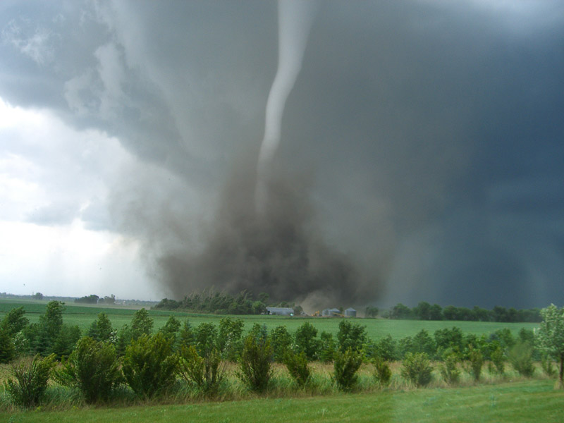
Tornadoes come from mainly two types of thunderstorms: supercell and non-supercell.
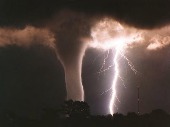
Tornadoes that come from a supercell thunderstorm are the most common, and often the most dangerous. A rotating updraft is a key to the development of a supercell, and eventually a tornado. There are many ideas about how this rotation begins. One way a column of air can begin to rotate is from wind shear – when winds at two different levels above the ground blow at different speeds or in different directions.
An example of wind shear that can eventually create a tornado is when winds at ground level, often slowed down by friction with the earth’s surface, come from the southwest at 5 mph. But higher up, at 5000 feet above the same location, the winds are blowing from the southeast at 25 mph! An invisible “tube” of air begins to rotate horizontally. Rising air within the thunderstorm tilts the rotating air from horizontal to vertical – now the area of rotation extends through much of the storm.
Once the updraft is rotating and being fed by warm, moist air flowing in at ground level, a tornado can form. There are many ideas about this too.
Scientists still have many questions. As few as 20 percent of all supercell thunderstorms actually produce tornadoes. Why does one supercell thunderstorm produce a tornado and another nearby storm does not? What are some of the causes of winds moving at different speeds or directions that create the rotation? What are other circulation sources for tornadoes? What is the role of downdrafts (a sinking current of air) and the distribution of temperature and moisture (both horizontally and vertically) in tornadogenesis?
And, since not all tornadoes come from supercells, what about tornadogenesis in non-supercell thunderstorms?
Non-supercell tornadoes are circulations that do not form from organized storm-scale rotation. These tornadoes form from a vertically spinning parcel of air already occurring near the ground caused by wind shear from a warm, cold, or sea breeze front, or a dryline. When an updraft moves over the spinning, and stretches it, a tornado can form. Eastern Colorado experiences non-supercell tornadoes when cool air rushes down off the Rocky Mountains and collides with the hot dry air of the plains. Since these types of tornadoes happen mostly over scarcely populated land, scientists are not sure how strong they are, but they tend to be small.
One non-supercell tornado is the gustnado, a whirl of dust or debris at or near the ground with no condensation funnel, which forms along the gust front of a storm.
Another non-supercell tornado is a landspout. A landspout is a tornado with a narrow, rope-like condensation funnel that forms while the thunderstorm cloud is still growing and there is no rotating updraft – the spinning motion originates near the ground.
Waterspouts are similar to landspouts, except they occur over water. Damage from these types of tornadoes tends to be EF2 or less.
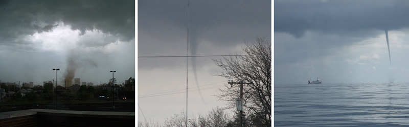
Non-supercell tornadoes include (L-R):
Gustnadoes, whirls of dust or debris at or near the ground with no condensation funnel, which form along the gust front of a storm.
Landspouts, narrow, rope-like condensation funnels that form while the thunderstorm cloud is still growing and there is no rotating updraft. The spinning motion originates near the ground.
It was beautiful out today!! I am looking forward to the 70’s they are forecasting this week. Even the night temps will be warmer. He said one more cold night and that is tonight. 🙂
IN April so far only 3 days of above normal temps and now this! When will it ever end?
http://www.cpc.ncep.noaa.gov/products/predictions/610day/610temp.new.gif
http://www.cpc.ncep.noaa.gov/products/predictions/814day/814temp.new.gif
So beautiful out today and now comes more 70’s and sun! Loving this weather.
More 70’s ??? indydog14!
Mookie is delusional! April has been way below normal and he keeps acting like it has been above normal! Three days above normal including one 70 degree day and and 26 below normal days! A COLD and SNOWY April to remember!
It looks like the official low at GRR this morning was 29° so no record low at Grand Rapids. However here at my house the low was 25° At this time have full sun and a current temperature at my house of 42° The grass has now turned green in my area. Still not enough to have to cut yet but that will change with the expected rain over the next few days. Gee I just drained the snow blower last week.
slim
Lansing’ s record low remained in tact also, which was set 150 years ago!
LOL!! I stand corrected, thanks Slim!! But 29 is definitely NOT mid-20’s, so still another Rocky swing and a miss!
Thanks for the facts! So GR was officially 29 degrees! Now that is some serious late April COLD!!!!!!!!!!!
One of the things I remember from the many Skywarn classes I’ve attended: Michigan tornadoes seldom are the “classic” supercell kind often shown from the plains. They tend to have ragged-looking wall clouds, funnels appear quickly and disappear just as fast. The same goes for Florida – many areas don’t even have warning sirens. So we need to heed those “warned radar-detected rotational storms” because they can drop a funnel in less than a minute. Also remember that a full radar sweep takes 4-1/2 minutes: I think I read that the tornado that cut a swath through Byron Center/Wyoming several… Read more »
I have only seen one tornado and that was up in Cadillac many years ago when I was a kid. We were camping at Mitchell State Park. Late in the afternoon there was a storm across the lake (it was not raining on the west side of the lake) and a lot of people reported seeing a “waterspout” over the lake. Me and my dad with to the shore and there it was a nice funnel on the east side of the lake. Found out later that a tornado touched down on the north side of Cadillac at the fairgrounds… Read more »
I was lucky enough to live just south of the 1979 tornado that traveled due east down 44th St from Grandville to Ada. I had been looking at a very dark cloud with the wide “V” base (not a classic wall cloud at all), then my sister who lived next door came over and said there was a tornado warning for Kentwood. Figuring I was probably witnessing a potential tornado, we went out on our deck and watched the “V” drop a tornado/rope out/drop another tornado. We had mostly-blue sky overhead and a ringside seat – watched it for perhaps… Read more »
ROCKY (Rockford)
Lows in the mid twenties tonight! Now that is some serious April COLD! WOW!
REPLY
1 day 2 hours ago
LOL!! Didn’t even get below 30 last night! Another swing and a miss!!
It looks like the official low at Grand Rapids will be 29°
Slim
Funny how some people on here keep talking about above normal temps when we are clearly in a below normal temp pattern and have been for months! April = cold and snow with 3 WWA’s a Winter Storm Warning! INCREDIBLE!
http://www.cpc.ncep.noaa.gov/products/predictions/610day/610temp.new.gif
http://www.cpc.ncep.noaa.gov/products/predictions/814day/
Well if you insist on keeping score, for the year so far we have 2 months above average, and April will make two months below average, which equals a 2-2 tie. That would mean pretty much exactly average. If you go long term over the past several years, I don’t know the score, but above average is winning by a long shot.