I have a 14 year old 4×4 truck I am getting back into shape for the possibility of storm chasing this year. I have had it for quite some time and just as us humans it has had some health issues over the past year. I have put $3000 into the thing over the past month for mechanical and electrical issues. I am leaving the body as is so hail damage won’t be an issue (ha, ha). Fixing up an old truck is a lot cheaper than buying new as one could spend over $40000.
I am retiring from my real job in the pharmaceutical industry in the first week of August so I can devote more time to weather related pursuits including this site.
Storm chasing is serious business and it is not for the uninitiated or the faint of heart. A co-pilot is a good idea to keep track of the radar and cloud formations outside of the drivers view (if any one is interested who lives in my area give me a holler). I have the computers and other equipment needed including a lightning tracker and anemometer.
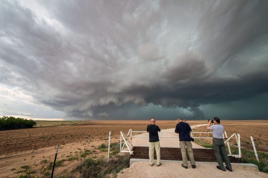
Storm chasing is broadly defined as the pursuit of any severe weather condition, regardless of motive, which can be curiosity, adventure, scientific investigation, or for news or media coverage.
A person who chases storms is known as a storm chaser, or simply a chaser. While witnessing a tornado is the single biggest objective for most chasers, many chase thunderstorms and delight in viewing cumulonimbus and related cloud structures, watching a barrage of hail and lightning, and seeing what skyscapes unfold. There are also a smaller number of storm chasers who intercept tropical cyclones and waterspouts.
Dangers
There are inherent dangers involved in pursuing hazardous weather. These range from lightning, tornadoes, large hail, flooding, hazardous road conditions (rain or hail-covered roadways), animals on the roadway, downed power lines (and occasionally other debris), reduced visibility from heavy rain (often wind blown), blowing dust, and hail fog. Most directly weather-related hazards such as from a tornado are minimized if the storm chaser is knowledgeable and cautious.
In some situations severe downburst winds may push automobiles around, especially high-profile vehicles. Tornadoes affect a relatively small area and are predictable enough to be avoided if sustaining situational awareness and following strategies including always having an open escape route, maintaining a safe distance, and avoiding placement in the direction of travel of a tornado (in most cases in the Northern Hemisphere this is to the north and to the east of a tornado).
Lightning, however, is an unavoidable hazard. “Core punching”, storm chaser slang for driving through a heavy precipitation core to intercept the area of interest within a storm, is recognized as hazardous due to reduced visibility and because many tornadoes are rain-wrapped. The “bear’s cage” refers to the area under a rotating wall cloud (and any attendant tornadoes), which is the “bear”, and to the blinding precipitation (which can include window-shatteringly large hail) surrounding some or all sides of a tornado, which is the “cage”. Similarly, chasing at night heightens risk due to darkness.
In reality, the most significant hazard is driving, which is made more dangerous by the severe weather. Adding still more to this hazard are the multiple distractions which can compete for a chaser’s attention, such as driving, communicating with chase partners and others with a phone and/or radio, navigating, watching the sky, checking weather data, and shooting photos or video. Again here, prudence is key to minimizing the risk.
Chasers ideally work to prevent the driver from multitasking either by chase partners covering the other aspects or by the driver pulling over to do these other things if he or she is chasing alone. Falling asleep while driving is a chase hazard, especially on long trips back. This also is exacerbated by nocturnal darkness and by the defatigating demands of driving through precipitation and on slick roads.
Incidents
For nearly 60 years, the only known chaser deaths were driving-related. The first was Christopher Phillips, a University of Oklahoma undergraduate student, killed in a hydroplaning accident when swerving to miss a rabbit in 1984. Three other incidents occurred when Jeff Wear was driving home from a hurricane chase in 2005, when Fabian Guerra swerved to miss a deer while driving to a chase in 2009, and when a wrong-way driver resulted in a head-on collision that killed Andy Gabrielson returning from a chase in 2012.
On 31 May 2013, an extreme event led to the first known chaser deaths inflicted directly by weather when the widest tornado ever recorded struck near El Reno, Oklahoma. Engineer Tim Samaras, his photographer son Paul, and meteorologist Carl Young were killed doing in situ probe and infrasonic field research by an exceptional combination of events in which an already large and rain-obscured tornado swelled within less than a minute to 2.6 miles (4.2 km) wide simultaneously as it changed direction and accelerated.
Several other chasers were also struck and some injured by this tornado and its parent supercell’s rear flank downdraft. Three chasers were killed, two in one vehicle and one in another, when their vehicles collided in West Texas in 2017, bringing the total number of known traffic related fatalities to 7. There are other incidents in which chasers were injured by automobile accidents, lightning strikes, and tornado impacts. While chasing a tornado outbreak on 13 March 1990, KWTV television photographer Bill Merickel was shot and injured near Lindsay, Oklahoma.
Storm chasing is a serious and dangerous proposition. I belong to the Spotters Network and am taking the classes which are required for storm chasing which go beyond those offered by the NWS spotter programs offered around our area.
Heads OR Eyes UP for The ISS…..For YOU Early AM Folks… The following ISS sightings are possible from Monday Apr 30, 2018 through Tuesday May 15, 2018 Date Visible Max Height Appears Disappears Share Event Tue May 1, 5:29 AM 3 min 13° 10° above SSE 10° above ESE Thu May 3, 5:20 AM 4 min 29° 14° above SSW 20° above E Fri May 4, 4:30 AM 2 min 16° 16° above SE 11° above E Fri May 4, 6:04 AM 4 min 64° 10° above WSW 35° above NE Sat May 5, 5:13 AM… Read more »
Too cold in 2018 for severe around here…unless the NWS reduces severe status to 25 mph breezes.
MV I can’t wait to read on your storm chaser trips. It has been beautiful out today. We put the screens in & opened the windows. 🙂
GO. GRIFFINS!!!!!
House plants are happy with this weather, too.
Happy Retirement to you… in a few months.
Another miserable, cold year in Michigan…aka, the southern Arctic.
Get ready Mr Negative we my actually see a stretch of warm weather sometime in June!
Very nice outside I think we can say officially spring is here … INDYDOG14!
Michael – congrats on your upcoming retirement – and have fun chasing! I’m no chaser, but do have a few open places nearby where I might drive to get a long-distance view of something brewing; and of course I have a wide-open view of anything headed towards Wayland/Caledonia/Grand Rapids simply by standing on my deck.
I have a great view of what’s coming from Lake Michigan. It’s fun to watch things move in whether it’s summer or winter.
The official low at GRR this morning was 30° here at my house the low was a colder 27° even with the sun and temperatures in the upper 50’s to 60° the very low dew points in the upper teens and the wind made it feel much cooler then that in the shade the last two days.
Slim
At this time, it looks like April 2018 will be the 4th coldest April in Grand Rapids history. We will know for sure tomorrow the current mean temperature at GRR is 39.7° and the current 5 coldest April’s are
1. 1907 37.6°
2. 1950 39.6°
3. 1975 39.8°
4. 1926 40.4°
5. 1904 40.9°
My guess it that this year will take over the 4th spot from 1926 with a projected mean of around 40.1°
Slim
You ROCK Slim! Mookie said this April was not cold at all, however the FACTS don’t lie baby!
Very warm week upcoming! WOOD has 70, 77, 76, and 73 starting today. In fact, the coldest high temp the next 8 days is 64 degrees.
Average high is 64 degrees – which could be around the low temp Tues and Wed night.
The average high temperatures are rising rapidly for the next few weeks by Tuesday the average high is 65 and by Thursday it is up to 67° and by May 7th it is up to 67°. The NWS has H/L of 68/50,78/62,75/58,72/58,68/52,62/45 and 60/40 over the next week so some warm days/nights then some near to slightly below average highs typical early May weather.
Slim
One last note for today. There are some indications that later in May we could see a turn to a rather warm pattern with a good chance of more active weather pattern (more storms)
Slim
My prediction a few weeks back was a warm start to May, then a cool down, then a warm finish. It looks to be playing out that way so far!