Today I begin a two part series on tornadoes – the conclusion will be on Sunday…
What is a tornado?
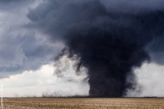
A tornado is a narrow, violently rotating column of air that extends from the base of a thunderstorm to the ground. Because wind is invisible, it is hard to see a tornado unless it forms a condensation funnel made up of water droplets, dust and debris. Tornadoes are the most violent of all atmospheric storms.Where do tornadoes occur?Tornadoes occur in many parts of the world, including Australia, Europe, Africa, Asia, and South America. Even New Zealand reports about 20 tornadoes each year. Two of the highest concentrations of tornadoes outside the U.S. are Argentina and Bangladesh.
How many tornadoes occur in the U.S. each year?
About 1,200 tornadoes hit the U.S. yearly. Since official tornado records only date back to 1950, we do not know the actual average number of tornadoes that occur each year. Plus, tornado spotting and reporting methods have changed a lot over the last several decades.Where is tornado alley?Tornado Alley is a nickname invented by the media for a broad area of relatively high tornado occurrence in the central U.S. Various Tornado Alley maps look different because tornado occurrence can be measured many ways: by all tornadoes, tornado county-segments, strong and violent tornadoes only, and databases with different time periods. Please remember, violent or killer tornadoes do happen outside “Tornado Alley” every year.
When are tornadoes most likely?
Tornado season usually refers to the time of year the U.S. sees the most tornadoes. The peak “tornado season” for the Southern Plains is during May into early June. On the Gulf coast, it is earlier during the spring. In the northern plains and upper Midwest, tornado season is in June or July. But, remember, tornadoes can happen at any time of year. Tornadoes can also happen at any time of day or night, but most tornadoes occur between 4–9 p.m.
What is the difference between a Tornado WATCH and a Tornado WARNING?
A Tornado WATCH is issued by the NOAA Storm Prediction Center meteorologists who watch the weather 24/7 across the entire U.S. for weather conditions that are favorable for tornadoes. A watch can cover parts of a state or several states. Watch and prepare for severe weather and stay tuned to NOAA Weather Radio to know when warnings are issued.
A Tornado WARNING is issued by your local NOAA National Weather Service Forecast Office meteorologists who watch the weather 24/7 over a designated area. This means a tornado has been reported by spotters or indicated by radar and there is a serious threat to life and property to those in the path of the tornado. ACT now to find safe shelter! A warning can cover parts of counties or several counties in the path of danger.
Watch this Youtube video for a great explanation!
How is tornado strength rated?
The most common and practical way to determine the strength of a tornado is to look at the damage it caused. From the damage, we can estimate the wind speeds. An “Enhanced Fujita Scale” was implemented by the National Weather Service in 2007 to rate tornadoes in a more consistent and accurate manner. The EF-Scale takes into account more variables than the original Fujita Scale (F-Scale) when assigning a wind speed rating to a tornado, incorporating 28 damage indicators such as building type, structures and trees. For each damage indicator, there are 8 degrees of damage ranging from the beginning of visible damage to complete destruction of the damage indicator. The original F-scale did not take these details into account. The original F-Scale historical data base will not change. An F5 tornado rated years ago is still an F5, but the wind speed associated with the tornado may have been somewhat less than previously estimated. A correlation between the original F-Scale and the EF-Scale has been developed. This makes it possible to express ratings in terms of one scale to the other, preserving the historical database
How do tornadoes form?
The truth is that we don’t fully understand. The most destructive and deadly tornadoes occur from supercells, which are rotating thunderstorms with a well-defined radar circulation called a mesocyclone. (Supercells can also produce damaging hail, severe non-tornadic winds, unusually frequent lightning, and flash floods.) Tornado formation is believed to be dictated mainly by things which happen on the storm scale, in and around the mesocyclone. Recent theories and results from the VORTEX2 program suggest that once a mesocyclone is underway, tornado development is related to the temperature differences across the edge of downdraft air wrapping around the mesocyclone. Mathematical modeling studies of tornado formation also indicate that it can happen without such temperature patterns; and in fact, very little temperature variation was observed near some of the most destructive tornadoes in history on 3 May 1999. We still have lots of work to do.What do storm spotters look for when trying to identify a tornado or a dangerous storm?
Inflow bands are ragged bands of low cumulus clouds extending from the main storm tower usually to the southeast or south. The presence of inflow bands suggests that the storm is gathering low-level air from several miles away. If the inflow bands have a spiraling nature to them, it suggests the presence of rotation.
The beaver’s tail is a smooth, flat cloud band extending from the eastern edge of the rain-free base to the east or northeast. It usually skirts around the southern edge of the precipitation area. It also suggests the presence of rotation.
A wall cloud is an isolated cloud lowering attached to the rain-free base of the thunderstorm. The wall cloud is usually to the rear of the visible precipitation area.
A wall cloud that may produce a tornado usually exists for 10–20 minutes before a tornado appears. A wall cloud may also persistently rotate (often visibly), have strong surface winds flowing into it, and may have rapid vertical motion indicated by small cloud elements quickly rising into the rain-free base.
As the storm intensifies, the updraft draws in low-level air from several miles around. Some low-level air is pulled into the updraft from the rain area. This rain-cooled air is very humid; the moisture in the rain-cooled air quickly condenses below the rain-free base to form the wall cloud.
The rear flank downdraft (RFD) is a downward rush of air on the back side of the storm that descends along with the tornado. The RFD looks like a “clear slot” or “bright slot” just to the rear (southwest) of the wall cloud. It can also look like curtains of rain wrapping around the cloud base circulation. The RFD causes gusty surface winds that occasionally have embedded downbursts. The rear flank downdraft is the motion in the storm that causes the hook echo feature on radar.
A condensation funnel is made up of water droplets and extends downward from the base of the thunderstorm. If it is in contact with the ground it is a tornado; otherwise it is a funnel cloud. Dust and debris beneath the condensation funnel confirm a tornado’s presence.
Thunder storm drought continues!! INDYDOG14!!
I for one am not missing the storms. I really dodn’t like severe weather.
Get used to the below normal temps!
http://www.cpc.ncep.noaa.gov/products/predictions/610day/610temp.new.gif
http://www.cpc.ncep.noaa.gov/products/predictions/814day/814temp.new.gif
60’s & 70’s are fine with me!! Fantastic morel growing weather and perfect spring weather!!
https://weather.com/weather/tenday/l/49504:4:US
Hi Kids – I’m baaaack! Florida was truly lovely – when everyone else was shivering, we seemed to have the only warm weather around. Which was good – FL had a LOT of damage from Hurricane Irma. When they say the “bad side” of a hurricane is on the east, they weren’t kidding – even though Irma was farther away from us on the east coast, she did more damage than Matthew which kept the state to its west. But now it’s hot and muggy there, and I’ve escaped back to our beautiful Michigan. The highlight of our winter? The… Read more »
Welcome home, Deb!
We were thinking of you during the hurricanes. Glad you’re safe.
That is so cool you got to watch the Falcon Heavy up close and personal. I watched it via livestream and that was great and all, but I couldn’t imagine being there.
Welcome back Deb!! My wife and I had a fantastic time near Pensacola during Spring Break at the beginning of April! It was nice getting out of the cold winter hell hole for a while and enjoy some beautiful warm weather!
Welcome back Deb. It is good to hear from you. 🙂
Will it even hit 50 degrees on Saturday and then watch out a for a HARD FREEZE on Saturday night! INCREDIBLE!
Your posts on here have the same style as Donald Trump’s twitter. Sad!
No what is pathetic is that the Trump tweets are filled with bigotry, name calling and lies! Please do not ever bring up Trumps name again on a weather blog!!!!!!!!!!!!!!!!!!!!!!
I thought you were moving to Canada because of Trump?? That’s what you promised on Election Day!
WOOD now has 70, 79, 72, 70 beginning Monday. That is almost summer weather!
I saw that!! You are right it will feel like summer! Looking forward to it.
That will feel nice and after the cold April we had it will feel even nicer!!!
BUT it is unusual?? Nope just a couple of years ago Grand Rapids had highs of 78, 85,82, and 81. But hey as it has been said it will be nice for a change this spring.
Slim
Get ready! The INCREDIBLE April cold continues!
Model soundings show profiles are cold enough for some snow to
mix in across the north this evening then spreading south
overnight. Precipitation should be gone off to the east by
Saturday morning. Cold surface high builds in with temperatures
about 10 to 15 degrees below normal Saturday and Saturday night
You also said this too:
ROCKY (Rockford)
Get ready! Highs in the 50’s the rest of the week = below normal all week!
REPLY
3 days 13 hours ago
And it has been all 60’s this week. So….I’m not going worry too much about a 50 percent chance of a rain snow mix that will melt on contact!
haha Busted!
That means I have had 4 predictions wrong all winter/spring and 96 correct, spot on predictions! A 96% accuracy rate! Truly an amazing record!!