
Cloudy skies are expected once again today, typical for November in SW Michigan. Temperatures will be in the mid-30s to near 40°.
Forecast
Weather History for SW Michigan
1886: A record cold snap continues across Lower Michigan. Lansing falls to 13 degrees below zero, as the temperature hits zero or below on the first five days of the month there.
1941: Three days before the attack on Pearl Harbor, Lower Michigan is basking in record-warm early December weather. Record highs include 60 degrees at Muskegon, 63 degrees at Grand Rapids, and 64 degrees at Lansing.
2009: A narrow band of heavy snow across central Ottawa and Kent Counties drops over a foot of snow from Allendale to Comstock Park. Up to 15 inches falls in northern sections of Grand Rapids.
Weather History for SE Michigan
On December 4, 1998, the overnight temperature did not drop below a balmy 51 degrees in Detroit.
U.S.A and Global Events for December 4th:
December 4, 1952:
The month of December started off with chilly temperatures in London. This cold resulted in Londoners burning more coal to heat their homes. Then on December 5, a high pressure settled over the Thames River causing a dense layer of smog to develop. The smog became so thick and dense by December 7 that virtually no sunlight was seen in London. Most conservative estimates place the death toll at 4,000, with some estimating the smog killed as many as 8,000 individuals. Click HERE for more information from the Meteorological Office in the United Kingdom.
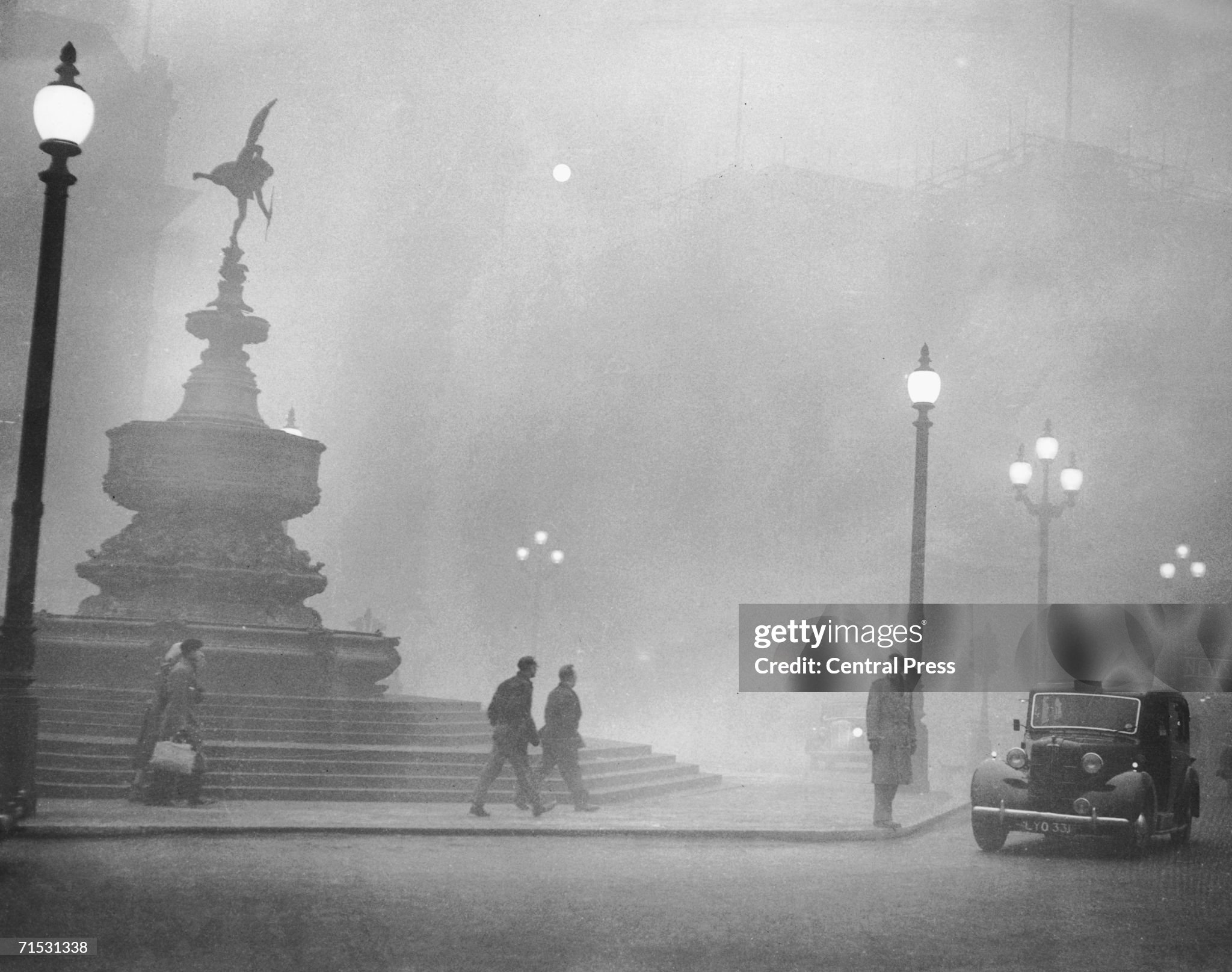
Piccadilly Circus in the smog on December 5, 1952.
Forecast Discussion
Lingering low-level wrap around moisture from a departing low is
supporting scattered showers early this morning for areas south
of a line from Holland to Lansing. These showers should gradually
diminish throughout the morning as the moisture source from the
parent low slowly moves further east. Dry conditions are expected
by noon with brief ridging.

Another quick clipper arrives late tonight into Tuesday morning
bringing precipitation for the southern half of the state. Highest
precipitation chances will be for areas along and south of I-96.
Forecast soundings continue to support snow for this system,
though above freezing surface temperatures and light QPF under 0.1
inches will limit accumulations to less than 1 inch.

Some lingering light snow/rain is possible Tuesday night into
Wednesday morning in the wake of the departing clipper system,
related to moist/cyclonic NNW flow. Pops will be confined to areas
mainly near and west of Highway 131 as this is primary driven by
lake effect/enhancement. With the DGZ likely becoming unsaturated
after 06Z Wed this could be more like a lake effect drizzle
situation before the sfc ridge arrives Wednesday afternoon.

An abrupt pattern flip arrives later Wednesday into Thursday as the
wrn upper ridge marches east and replaces our departing longwave
trough. Strong southwest flow sends a warm front through the region
early Thursday, which could produce a brief bout of light snow/rain
on Wednesday night mainly north of I-96.

Predominately dry weather with well above normal temperatures is
expected to prevail on Thursday and Friday before the upper ridge
gets flattened by new energy streaming in from the Pacific and
crossing the Rockies. High temperatures rise well into the 40s on
Thursday then into the 50s on Friday before a frontal boundary leans
in from the west on Saturday.

Precipitation chances increase next weekend as a longwave trough
digs over the central U.S. and a slow moving/stalled baroclinic zone
sets up from MI to TX. Deterministic and ensemble guidance is
suggesting that a strong cyclone could develop along that baroclinic
zone and sweep through the GrtLks Rgn at some point late in the
weekend. As is typical that far out though there is considerable
spread with respect to sfc low track/timing/strength as well as
potential p-types/amounts.

Needless to say this will need watched because if we end up on the
cold side of that potential strong system there may be significant
snow accumulations while being on its warm side could support
locally heavy rainfall and perhaps some strong tstms.
Breaking>>>>>possible snowstorm for lower MI coming! Incredible!
Preheat, no said anything about having above normal snowfall! WOW!
I’m with you there Rocky. I don’t remember anyone saying above normal snow for November.
No one ever said anything about above normal snowfall in November! Incredible!
Phew November had below normal snowfall despite some people telling all month it was above normal! Who knew?
Phew November had below normal temps despite some people telling all month it was above normal! Who knew?
Phew! Looks pretty mild coming up!
It rained again this morning – the 3rd consecutive day. Very soggy in these parts and pools of standing water are a common sight. We need a legit drying off period.
So far there has not been a 1” or more snow fall at Grand Rapids this winter season. The average date is November 19th The total snowfall at Grand Rapids so far this winter season is just 2.0” that is now -7.0” below average.
Slim
Snow deficit growing already!
How could that be?!?!! Some people said that we were getting pummeled with snowfall all November??
The official H/L yesterday was 38/33 there was once again a cold rain with 0.28” of rain fall and 0.1” of snowfall. There was a trace of snow on the ground yesterday at 7AM. There was no sunshine. For today the average H/L is 40/28 the record high of 65 was set in 2012 and the record low of 6 was in 1893. The wettest December 4th was in 1993 with 1.27” and the most snow fall was 5.9” in 2009. The most snow on the ground was 12” in 1940. Last year the H/L was 38/21.
Slim
I am kind of surprised the average high is still 40 degrees. Must have increased a few degrees since the 1980-2010 average.
Also the possibility of strong thunderstorms (still a week away, quite low) is pretty cool for mid-December!
For today the current 30 year average high is 39.6 and the average low is 27.5. Starting tomorrow the average H/L is 39(39.2) and the average low is 27(27.3) The coldest average high at Grand Rapids for December is 33.6 on the 31st
Slim
Seems a couple degrees warmer than it used to be. We don’t even have an average high below freezing all month of December anymore, kind of surprising
There has been remarkable consistency in the computer models showing a strong storm system somewhere in the Great Lakes Region in the Sunday/Monday timeframe. Obviously was too far out for specifics but computer models locked onto this starting Saturday and still showing it. Our local office alluded to this in the AM discussion. One to watch closely. All snow scenario would produce significant accums and very windy conditions. A warm scenario could even spark strong thunderstorms. Obviously way to soon to know the outcome or if we will get anything at all. Something to watch.