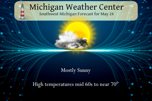
Cooler air will arrive today behind a cold front. A few sprinkles are possible across central Lower Michigan, with otherwise mostly sunny skies. At Lake Michigan, dangerous waves and currents are expected at some beaches. A chilly night is ahead, with frost/freeze temperatures expected in many areas. Otherwise, dry weather is likely into the foreseeable future — at least well into next week.
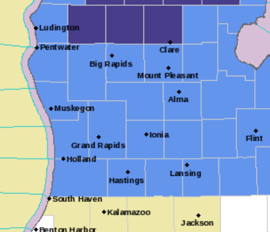
Frost Advisory – blue. Freeze Warning, dark blue
Grand Rapids Forecast
5 24 grrWeather History for SW Michigan
May 21
2001: A swarm of at least 20 tornadoes descends on Lower Michigan. Fortunately, most of the tornadoes are relatively weak, and only five people were injured. Damage included dozens of trees downed, barns blown over and roof and siding damage to several homes. Three homes and a golf course were heavily damaged north of Hartland in Livingston County.
2004: Severe weather causes widespread damage across southern Lower Michigan. Thunderstorm winds up to 70 mph, large hail, and flash flooding occurred as a squall line moved from Benton Harbor to Ann Arbor. Hundreds of trees are knocked down and thousands lose power.
May 22
1917: Cold rain mixes with snow and temperatures rise only to the lower 40s after morning lows in the lower 30s.
1963: Snowflakes fall at Lansing as morning low temperatures in the 30s only rise to the mid and upper 40s.
May 23
1966: A barn was destroyed by a tornado near Gobles in Van Buren County.
1973: A tornado destroyed three barns and damaged an industrial building in Winn in Isabella County.
May 24
1890: One person was injured as a tornado destroyed one home and a dozen barns northeast of Ithaca in Gratiot County.
May 25
1925: Lansing records its latest snow on record as snowflakes fall there with a low temperature of 32 and a high of 47 degrees.
1992: Widespread freezing temperatures do heavy damage to the fruit crop across southwest Lower Michigan. Record lows for today include 29 degrees at Lansing, 31 at Grand Rapids, and 32 at Muskegon.
2006: Two weak tornadoes caused no damage as they briefly spun up between Beebe and Breckenridge in Gratiot County.
May 26
1961: Snow flurries are observed across Lower Michigan as record cold air moves in. Temperatures fall well below freezing the next morning, wiping out much of the fruit crop.
May 27
1907: Wet snowflakes fall at Grand Rapids and Muskegon. It is the latest snow on record at Grand Rapids.
1912: A tornado destroys barns and kills livestock near East Leroy in Calhoun County.
1960: Several farm buildings were damaged or destroyed by a tornado four miles east of Ionia.
1973: A tornado destroyed a barn and silo near Saranac in Ionia County. Another tornado did minor damage near Gun Lake in Barry County.
Weather History for SE Michigan
May 21
On May 21, 1953, an F4 tornado moved through St. Clair County at 4:21 PM. This tornado is responsible for 2 deaths and 68 injuries. It ties with an F4 tornado that formed on June 8, 1953, as the strongest tornado ever to hit St. Clair County.
Also on May 21, 2001, an F2 tornado hit Hartland and dissipated near Fenton. Other weak tornadoes hit Oakland, Lapeer, Shiawasee, and Saginaw Counties.
May 22
On May 22, 1883, a very late-season snowstorm hit Detroit with five inches of snow accumulating during the overnight hours.
May 23
On May 23, 1963, the overnight temperature dropped to 28 degrees in Flint, which is the record-low temperature for the day. Interestingly enough, the very next year, in 1964, the daytime temperature rose to 87 degrees, setting the record high temperature for the date. This high-temperature record was equaled and thus superseded in 2007
Also on May 23, 2004, severe thunderstorms rolled across all of Southeast Michigan. One storm produced a 70 mph wind gust at Detroit Metro Airport which caused damage to a building under construction and one injury. The storms dropped 1.69 inches of rain on Detroit, 1.39 inches on Flint, and 1.41 inches on Saginaw. That was the last of the heavy rainfall that pushed May of 2004 to the wettest May on record (Detroit – 8.46 inches, Flint – 8.19, Saginaw – 8.14). As a result, widespread flooding across Southeast Michigan caused over 100 million dollars in damages.
May 24
On May 24, 1925, the temperature climbed to only 44 degrees in Detroit, setting the record for the record-low maximum on this day.
Also on May 24, 1971, an F2 tornado moved through Tuscola County at 8:30 PM. This tornado is responsible for 1 injury and over $50,000 in damage. This was the strongest tornado ever to hit Tuscola County since 1950.
May 25
On May 25, 1896, an estimated F5 tornado touched down and moved northeast for about 30 miles, affecting portions of Oakland, Lapeer, and Livingston Counties. Towns affected included Thomas, Ortonville, and Oakwood just after 9:00 pm. With 47 deaths, this is the second deadliest tornado ever in Michigan trailing only the Flint-Beecher Tornado of 1953. Nine of the fatalities were in a single home in Ortonville and parts of some homes were found dozens of miles away. Twenty-two people were killed in Ortonville, ten in Oakwood, three in Thomas, four in North Oxford, and three in Whigville with others in more rural areas. Other significant tornadoes occurred in Tuscola County with one fatality, and in Mt. Clemens where two people died when 30 homes were destroyed.
On May 25, 1994, Linden reported 3-inch hail at 6:30 pm which caused $5,000,000 in crop damage.
Also on May 25, 2011, thunderstorms produced heavy rain across much of Southeast Michigan. Flint received 1.28 inches, Detroit Metro Airport had 1.67 inches and Detroit City Airport recorded 3.03 inches. This rainfall added to the already very wet spring to produce numerous flooded roads and a few flooded homes. In fact, this rainfall helped to push Flint to its 2nd wettest May and wettest Spring on record. It was the 2nd wettest spring in Detroit records.
May 26
On May 26, 1968, 2.56 inches of rainfall fell in Detroit. This is the greatest daily rainfall total for the month of May in Detroit.
May 27
On May 27, 2012, Numerous trees were downed and the awning was torn off of an I-75 rest stop located near Exit 160 as thunderstorm winds of up to 75 mph swept across parts of Saginaw and Bay counties.
On May 27, 1987, a two-day streak of temperatures at 90 degrees occurred on the 27th and 28th in Flint. Also on this date in 1994, there was a two-day streak of record lows on the 27th at 31 degrees and the 28th at 36 degrees.
Cold front moves through today with little moisture to work with.
Cut POPs that were limited to begin with across the northeast
forecast area. Strong cold advection this afternoon and evening on
northeast winds will result in overnight lows dropping to near or
below freezing across the northern interior and in the mid to
upper 30s across the rest of the forecast area.

We have issued a Freeze Warning for Lake, Osceola and Clare
Counties and a Frost Advisory for all but the southern tier.
Surface high remains across the Great Lakes region through the
rest of the week with moderating temperatures but another cold
night is expected with frost/freeze potential for Thursday night
as well.

Omega block develops then transitions to a rex block, keeping dry
weather in place through early next week. It may be early June
before the pattern yields a chance of measurable rain.
Prepare Now! Temps in the 30’s and frost is coming to a neighborhood near you!
What a loss Ms. Tina Turner!!! I hope she is marching down the golden path with her big heals. Lol
Prepare now! Long term blowtorch setting up over the northern half of the US!! Looking like a nice long summer indeed!!
Nice cool breeze today!
NWS GR:
“Also of note is the continued absence of precipitation from the fcst. Some of our latest medium range guidance ensembles suggest it may take until around the second week of June for the larger scale wx pattern to transition”
“For the foreseeable future though the wx pattern looks quite warm to potentially hot and dry.”
Wow, that would be 5-6 weeks of no precipitation. This is going to put the farmers drought resistant seedlings to the test.
Ok weather friends. I have all my house plants out on front porch or under a deck… do I need to bring them in tonight? All of them are covered either by the deck or the porch roof…
Thanks So Much
I’d say if you are in the frost advisory, and you only have a handful of plants to move, it is probably safest to bring them in tonight and tomorrow night.
Ugh.. that’s what I thought… Lol. Some are little not a big deal, but the other 2 are BIG!! I keep saying to hubby I just need a greenhouse 😁
Nothing better then 60″s in the last week of May I love short Summers !! Who knew?? INDY
Rock on Indy! Who would want temps in the 90’s with humidity? Short summers are fantastic! Let’s keep this overall cool pattern rocking!!
What? Hot weather for Kent County and GR with temps in the 90’s next week?!?! Who would have thought? Certainty not the Cold weather crazies! Incredible!
https://weather.com/weather/tenday/l/b523690bfd952b86fef3627c919dd9855281a8da16b83c10bdd381c64ae12cbc
Eeee Eeee Eeee Blowtorch alert!
Our beautiful Fall like weather continues as we are days away from June who would of thought??? Frost and frezzing Warnings crazy!! INDY
Incredible late May cold!
Glad it will be a little cooler today. Early evening we will be going with family, sister’s and parents to go replace flags as the ocal cemetery our family tradition.
Should be local… Not ocal. Ugh!
The driest summer I personally ever remember in West MI was 2012. Talk about “crunchy” lawns that year. That was a very extreme summer.
While it’s not always the case when you get locked into these dry patterns sometimes they can be hard to get out of. I do not see any rain through at least the first couple days of June. I for one hope the patterns turns around for the sake of the farmers. If it does indeed continue dry into June you can expect some very warm/hot days ahead. But all that depends when the rains return.
Bring on the rain!!
What? A frost advisory for Kent County and GR with temps in the 30’s! Who would have thought? Certainty not the warm weather fanatics! Incredible!
Looks like my favorite range of temps is about to arrive! Nothing better than 80-90. I’ll even take hotter than that. I prefer hot summers over cool ones since the season is so short.
Still no 30’s in WOOD’s forecast but I do see temps creeping close to 90!
It is getting dry and with the dry ground and low dew points there can be larger swings in the temperatures. In 1988 May was dry and on the 25th of May the low was in the low to mid 30’s on the 25th and 26th at Grand Rapids and Lansing, but then reached up into the upper 80’s to low 90’s by the end of the month. June of 1988 seen many days with highs in the upper 80’s to the upper 90’s but lows were often in the 50’s. I am not saying that this year will be… Read more »
You are wrong again! Who knew?
The official H/L yesterday was 82/50 there was no rain, There was 81% of possible sunshine but there still was a good deal of smoke giving the sky a white look. There were no HDD’s and 1 CDD’s For today the average high low is 73/51 the record high of 89 was set in 1977, 2007 and 2010. The record low of 33 was set in 1925 and 1963. The record rain fall of 1.5” fell in 1981.
Slim
It very well could be that there will be no rain fall the rest of May. If so the month will end up with less than a inch of rain fall at Grand Rapids, Muskegon and Lansing. At Grand Rapids the 0.84” so far would be the 2nd lowest for any May. The 0.86” at Muskegon and the 0.96” at Lansing would be the 5th least for any May.
Slim
The big news in the next 5 days is that there is a frost and freeze warmings out for tonight. Lows could fall into the low to mid 30’s so many will have to cover their tender plants tonight and it looks to get down into the 30’s once again on Friday morning as well. Then it looks to warm up during the daytime but with low dew points it will cool down at night.
Slim
Oh my goodness. I don’t recall hearing about the May 25, 1896 tornado.
I am golfing all day at a charity fundraiser. Always a good time and it is for a great cause. Have a fantastic day friends and make someone smile. 😀
P.S. Frost advisory so I’m certain Rocky will be smiling. 😉
And it looks like according to Mookie and Andy W That WOOD’s forecast of no lows in the 30’s might have been wrong. I see that this week has had the latest reported snow in our area.
Slim
I know Rocky loves it when the farmers in the area could potentially lose all their crops from frost, just so he can troll people who would rather have warmer weather! Yeah…..it’s just so hilarious…..