
Yesterday our high temperature was 64° and the morning low was 55°. Rainfall was .56 of an inch which gives us a total of 2.12 inches for the month here in Otsego. Today we won’t see as much rain as yesterday as any showers that develop will be of a scattered variety. Temperatures will remain cool over the area with highs in the 60s today and tomorrow.
Grand Rapids Forecast
9 12 grrHurricane Lee Update

U.S.A and Global Events for September 12th
1857: The SS Central America sinks during a hurricane, killing 425 lives. Fourteen tons of gold was aboard the ship as well. Click HERE for a tweet from the Library of Congress.
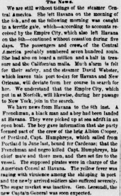
The newspaper clipping above is from the New York Herald. September 17, 1857, MORNING EDITION, Page 4, Image 4, and is courtesy of Chronicling America.
1950: A hailstorm struck southern parts of Oklahoma City on this day. The storm damaged about 4,000 homes, 300 businesses, and 750 cars, resulting in a loss estimated at $987,000.
1961: Super Typhoon Nancy was an incredibly powerful tropical cyclone of the 1961 Pacific typhoon season. The system had possibly the strongest winds ever measured in a tropical cyclone and caused extensive damage and at least 173 deaths and thousands of injuries in Japan and elsewhere. A reconnaissance aircraft flying into the typhoon near its peak intensity on September 12 determined Nancy’s one-minute sustained winds to be 215 mph. If these values are reliable, they would be the highest wind speeds ever measured in a tropical cyclone. However, it was later discovered that measurements and estimations of wind speeds from the 1940s to 1960s were excessive. Thus, Nancy’s winds may be lower than its official best-track value.
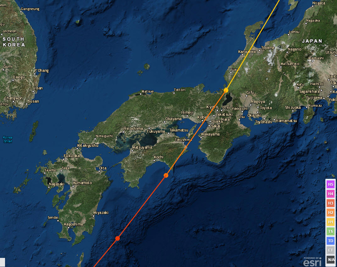
Typhoon Nancy made landfall on September 16 over Muroto Zaki.

Super Typhoon Nancy of 1961 on September 14th. The image is courtesy of the US Navy.
1963: President Kennedy gave his, “We choose to go to the moon” speech at Rice University.

Click HERE for a tweet from the NWS Office in Houston Texas.
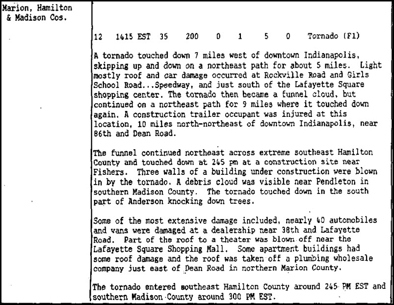
1988: An afternoon F1 tornado skipped across sections of Indianapolis, Indiana, damaging roofs and automobiles.
1999: Hurricane Floyd, a Category 4 storm with top winds of 145 mph, was making residents along the U.S. East Coast very nervous as it steamed steadily westward. Floyd was once forecast to strike Florida but turned away. Instead, Floyd hit the Bahamas at peak strength, causing substantial damage. It then paralleled the East Coast of the United States, causing massive evacuations and costly preparations from Florida through the Mid-Atlantic States.
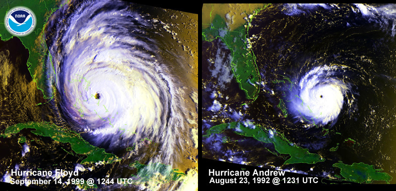
Above is a visual comparison of Hurricane Floyd and Hurricane Andrew. The two storms are at similar positions and nearly equal intensities (933 mbar), but Hurricane Floyd is remarkably more massive.
2006: Major flash flooding occurred in a matter of minutes after torrential rain started pounding the city of Evansville, Indiana. A total of about 250 occupied structures sustained some degree of damage. Over 30 water rescues were conducted from cars stalled in floodwaters. Click HERE for more information from the NWS Office in Paducah, Kentucky.
Forecast Discussion
...Isolated showers today...

Radar shows a large area of light rain falling across the
southeast cwa. This is along the cold front that passed through
the region yesterday. Isolated showers remain over the lake at
this time.

Water vapor imagery shows a large upper trough over the upper MS
valley which will swing down across Michigan today. This trough
will bring down some cooler temperatures aloft; h8 temps fall to
4c by Wednesday morning. Given lake temperatures around 17c, there
is enough over-lake instability for lake effect showers to
develop, especially given the lift from the approaching trough.
Because of this, we nudged PoPs above model guidance
today...although still in the isolated category today.

A stronger short wave drops south through the trough tonight but
the lift from that will mainly affect the far southwest cwa.
There`s a little bit of MUCAPE over the southern portion of Lake
Michigan tonight and it`s there, in conjunction with the
approaching short wave, that we could see an isolated
thunderstorm. Left it out of the grids, though, because chances
are low. Once the trough axis moves through late tonight, the
precipitation should end leading to some sunshine Wednesday.

Highs today will be in the mid 60s followed by lows in the 40s
tonight. Wednesday will be the coolest day of the week with highs
in the lower to mid 60s.

The long term period begins with high pressure in place at the
surface Wednesday night which will lead to cold morning lows.
Thursday morning we will likely have some readings dip into the 30s
across Central Lower Michigan with some frost possible. The surface
high slowly slips away to the east on Thursday and Friday and
southerly return flows sets up. By Saturday an upper trough in the
Northern Plains will push a cold front our direction that will
approach from from the west on Saturday. Our thinking is that our
area will remain dry on Saturday with the precipitation not
moving in until Saturday night. Saturday night through Monday, the
upper trough will be overhead and its associated cold front will
slowly traverse the area. Rainfall with this front is not expected
to be heavy, on the order of a half inch or less. We return to
dry weather on Tuesday with zonal upper flow setting up.

As for temperatures through the period, the normal high/low in Grand
Rapids for today is 76/55. Wednesday night  will see well below
normal temperatures with lows in the 30s and 40s. From Thursday
onward, readings will remain slightly below normal with an upper
trough moving in. Highs will generally be in the upper 60s to lower
70s.
Lots of leaves already falling for mid September it should be a early peak this Fall Im thinking with all cool nights ….INDY
Today was yet another below normal temp day for GR! What an incredible pattern!
It’s a lovely, windows open type of September day. I really enjoy this time of year.
Well, that was unnecessary…just received a strong, four minute downpour while working in the yard 🙁
The GR NWS rocks and facts are facts baby! Below normal temps rule!!!
The below normal temp pattern continues unabated! GR has been in an overall below normal temp pattern all year! Incredible!!!
Here is a fun fact the current September mean is 68.9 at both Grand Rapids and Lansing but the departure is +1.9 at Grand Rapids and +2.9 at Lansing. One reason for that is that in the past it was colder at Lansing.
Slim
The correlation between Lansing and most other reporting stations in Southern Lower Michigan is much higher than their correlation to GR. This points to major reporting issues at GR when comparing temps to average – something NWS GR is acutely aware of. Until it’s fixed, I would not follow NWS GR for temp departures.
Yesterday was a cool and wet day. The official H/L at Grand Rapids was 65/55. The official rain fall amount of 1.04” was the 6th wettest for any September 11th There were 5 HDD’s the highest wind speed was 16MPH out of the SW. And there was 0% of sunshine. For today the official H/L is 76/55 the record high of 95 was set in 1952 and the record low of 37 was set in 1964. The record rain fall amount of 1.54” fell in 1896. Last year the H/L was 66/52 and there was a trace of rain fall.… Read more »