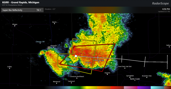
After a quiet summer storm wise we had our first tornado warning of the year for the area. I began tracking the storm at 6:30pm as it practically formed over Otsego and began to move east. We picked up 3/4 of an inch of rain in 10 minutes with some thunder and lightning. The cell began to show vortex signatures as it moved towards Plainwell dropping some pea sized hail. As it moved towards Richland trash cans and other objects we tipped over. It was the area along the north end of Little Long Lake — which runs just north of Gull Lake, west of M-43 — where the most damage occurred and it is believed a low level tornado touched down. The feature image is the Radarscope screenshot at 6:56 when the warning went up.
Below is the screen capture of the super-res velocity image at 6:45pm as I was tracking the storm on Radarscope. The red blob in the center is the signature of a possible tornado embedded in the storm cell. The white lines show the possible storm track and the white dot east of Otsego is the hail report. I called the possibility of severe weather just before the tornado warning went up.

Sirens went off in Otsego, Plainwell and Allegan when the warnings went up even after the storms had past. Looking at the criteria on the sirens activation I found that they are still controlled locally in the city where they are located. If there is a tornado or thunderstorm warning in the county they will go off. Some will sound again after the warnings have expired. To me this can be confusing. When I worked at Perrigo if there was a warning within the county they would herd everyone into a storm shelter. For me it was frustrating as I tracked the storms and saw they were moving away from the company but it was securities call and they were looking at safety first.
I am still waiting for the CoCoRaHS rainfall totals to populated. We had .96 inches yesterday, most of which fell during the storm. We have picked up another inch from rain which fell early this morning. For the first two days of September we have over 2 inches.
Periods of showers and thunderstorms will continue through this week as a stalled front remains across the Great Lakes, with occasional waves of low pressure moving along it. With what happened yesterday evening it is a good bet you should keep you eyes on the skies. Even though rain and storm chances are in the 30 to 40% range they can pop up at any time.
Heavy rain…again –
That was one inch of rain in thirty minutes…heavy.
Still no 90’s or any heat waves in sight!
Looks like all the fun misses us to the NW this evening 🙁
Another hot one. With dew points in the 70s, heat indices are already in the 90s. Off to the lake.
Record warm summer up at the Sault. And a top ten at many other locations. Summer (June/August) 2018 will not go down in history as the warmest up at Sault St Marie Here is some more information on this. Sault St Marie 2018 summer mean 67.4° average mean 63.3° departure +4.1° rank warmest. Houghton Lake 2018 mean 68.2 average mean 65.0 departure +3.2 rank 7th warmest Apena 2018 mean 68.1° average mean 65.0° departure +3.1 rank 3rd warmest Traverse City 2018 mean 71.1° average 66.8 departure +4.7° rank 3rd warmest Gaylord 2018 mean 67.1° average mean 64.1° departure +3.0 rank… Read more »
ADA – Our first thunderstorm passed over, and all around Ada last night. Didn’t get enough sleep, but received 1.4 inches of heavy rainfall.
More storms yesterday! Yesterday was also +7 degrees above average despite some on here saying it wasn’t very warm. About to get even warmer!
Some food for you Mookie see above. The summer of 2018 was the warmest on record at the Sault. records there go back to 1888. Also a top ten at several other locations. Too bad the UP is so far away that the will not count.
Slim
Good storm this morning out at thee YARDofBRICKS loud thunder heavy rain .
. INDYDOG14!
My total event rain fall amount here for yesterday and this morning is 2.09″ at this time the sun is out and the current temperature here at my house is 74°
Slim
Finally, an interesting weather event. Here is a storm report from the SPC, not far from me:
0035 UNK 4 NE BATH CLINTON MI 4286 8440 LOCATION IS THE MID POINT OF A 3.8 MILE DAMAGE PATH. TREES DOWN AND SOME ROOF DAMAGE TO HOMES. POSSIBLE TORNADO. TIME ESTIMATED FROM RADAR. (GRR)
0038 UNK 4 NE BATH CLINTON MI 4286 8440 NUMEROUS TREES DOWN BLOCKING CUTLER AND UPTON ROADS. TIME ESTIMATED FROM RADAR. (GRR)
Yeah Mark, I have a nice pond in the back yard this morning! We got a ton of rain over here in Northwest Kent County! Looks like the sun is going to dry things out today.
We only got a little less than a inch of rain, but lots of lightning and thunder.