Yesterday our low was 31.5 and the high was 35. We had a brief period of partly sunny skies in the afternoon.
We have a Winter Weather Advisory for Oceana, Newaygo, Montcalm, Gratiot, Mason, Lake, Mecosta, Osceola, Claire, and Isabella Counties beginning at 4 pm today expiring at 7 am tomorrow morning. It is for a mix of precipitation of rain, freezing rain, and snow.
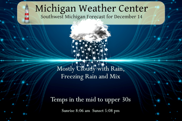
Our weather pattern becomes more active today with rain mainly south and east of Grand Rapids and a mixed bag for the counties north. Lake Michigan’s snow machine begins cranking up on Friday on through the weekend.
7-Day Forecast 42.5°N 85.62°W 12 14
Weather History for SW Michigan
December 11
1995: A spell of frigid weather continues with high temperatures of only 10 degrees at Grand Rapids and 11 degrees at Muskegon.
2000: A blizzard strikes southern Lower Michigan with record snowfall and strong winds causing heavy drifting, and shutting down travel. The 14.5 inches of snow that fall at Lansing is the heaviest on record for any December day. The 14.2 at Grand Rapids is also a record for any day of the month and contributes to December of 2000 becoming the snowiest month ever recorded there.
December 12
1949: Balmy weather continues. For the second day in a row, temperatures set record highs at Grand Rapids and Lansing.
1958: Arctic air continues across Lower Michigan. Record cold temperatures include 5 below zero at both Grand Rapids and Muskegon.
December 13
1920: Mild weather prevails across Lower Michigan with record highs in the upper 50s.
1973: A snowstorm drops about 8 inches of snow from Grand Rapids to Lansing.
December 14
1907: A snowstorm moves across Lower Michigan, dropping from 5 to 8 inches of snow.
1975: Record warmth continues for the second day across Lower Michigan. Morning lows in the upper 40s are followed by high temperatures near 60 degrees.
December 15
1971: For the second time in 5 days, record-high temperatures are followed by record rains. The temperature hits 60 at Grand Rapids and 64 degrees at Lansing followed by about 2 inches of rain.
1987: A winter storm drops from 8 to 12 inches of snow from Grand Haven to Ludington. Muskegon sets a daily snowfall record of 12.1 inches of snow.
December 16
1984: Mild weather prevails with record highs of 61 degrees at Lansing and Grand Rapids.
1989: Persistent cold weather continues during the coldest December on record in Lower Michigan. A record low of 2 below zero is recorded at Grand Rapids while another 5 inches of snow piles up at Muskegon, contributing to a monthly total of 77 inches there.
December 17
1963: Lake effect snow buries Muskegon with a three-day total of 34 inches of snow from the 16th to the 18th. This will be the snowiest December in Muskegon history with a grand total of 82.6 inches for the month.
SE Michigan Weather History
December 11
On December 11, 2000, a powerful storm system moved east just south of Michigan, dumping heavy snow across all of the areas, with some freezing rain and sleet near the Ohio border. Near blizzard conditions with up to 58 mph wind gusts were found across all of the areas, with an outright blizzard in the Thumb. Many schools were closed for two to four days after the storm. Mail delivery the next day was spotty at best, and many businesses and government offices were closed. Specific snowfall amounts and impacts of the storm, by county… Bay: 8 to 10″ in Bay City. Genesee: 12-14″ fell, along with 4-foot drifts. Flint Bishop International Airport closed in the afternoon of the 11th and ended up with 14″, the third largest snowfall on record. Up to 200 cars were stranded on Interstate 75 just south of Flint during the storm. In Burton, the roof of a window manufacturing company collapsed. Huron: 16.2″ in Port Hope. Lapeer: 12-16″ near Lapeer (city), with 3-foot drifts. Interstate 69 was closed from Davison to Imlay City. Lenawee: 5.7″ in Adrian with some freezing rain. Livingston: 10-15″ with 3 to 5-foot drifts. Macomb: 12″ across the county. Midland: 7 to 11″ in Midland (city). Monroe: 8.5″ just southeast of Milan; up to half an inch of freezing rain in Monroe with several trees down due to ice and wind, and power outages. Oakland: 12″ across the county. St Clair: 12.3″ near Avoca; 14.7″ in Ruby; 17.5″ in Yale, 14″ in Capac. In Port Huron, 12-20″, closing the Blue Water Bridge to Canada. Saginaw: 11″ in Frankenmuth with 3-foot drifts, roads drifted shut. MBS (Tri-Cities) International Airport had many flights canceled, and the airport was closed at 830 pm on the 11th. Sanilac: 13″ in Brown City. Shiawassee: 15.5″ in Morrice. Tuscola: 10-14″ in Vassar. In Caro, 16.3″ of snow fell with 4-foot drifts. An 18-car pile-up on the north side of town required snowmobiles to rescue stranded motorists. Washtenaw: 8-12″ in Ann Arbor; closing Eastern Michigan University for only the second time ever. Wayne: 6-12″ across the county; three-eighths inches of freezing rain in Rockwood; At Detroit Metropolitan Airport, 6.1″ fell, with 197 departures and 165 arrivals canceled.
December 12
On December 12, 2016, a snowstorm wrapped up in the early morning hours after snowing for much of the previous day. Snow measurements across Southeast Michigan generally ranged from 8 to 11 inches. NWS White Lake measured 11.3 inches and Flint 10.4 making it their 9th and 15th largest single-event snow accumulations on record respectively.
Also on December 12, 2010, low pressure tracked near the Michigan/Ohio border and then northeast into Ontario. Precipitation started as rain before changing to snow. Snowfall accumulations across southeast Michigan were generally in the 3 to 7-inch range before Arctic air rushed into the region. The quick freeze created a thick accumulation of ice on many of the area roads. In addition, gusty winds of 25 to 40 mph occurred during Sunday afternoon leading to scattered power outages. Some of the higher snowfall reports included Bad Axe with 15 inches, Yale with 9 inches, White Lake with 7.7 inches, Clifford with 7 inches, Midland with 7 inches, Riverview with 6.4 inches, and Howell with 6.3 inches.
Also on December 12, 1949, the record high temperature for the day was set at 61 degrees in Detroit, Flint, and Saginaw simultaneously! This is 27 degrees above average.
December 13
On December 13, 2017, a clipper rapidly strengthened upon approaching the area and brought significant snow accumulations. With calm winds and perfect temperatures, the environment was pristine for classic snow dendrites and efficient accumulation rates. A wide swath of 6 to 9 inches was observed along a northwest-to-southeast line from the Saginaw Valley into Detroit.
Also on December 13, 2010, additional lake effect snow fell in the wake of the previous day’s snowstorm across the Thumb region. Storm totals reached 15 inches at Bad Axe and an estimated 20+ inches near the Lake Huron shoreline in Huron County. Wind gusts to 50 mph were reported across the northern Thumb region and created snow drifts in excess of 10 feet is some locations. The snow and blowing snow led to Blizzard conditions over Huron and Sanilac counties, which stranded at least two dozen cars.
Also on December 13, 1878, this day marks the first day of a streak of 38 days (December 13, 1878-January 20 1879) of temperatures at or below 32 degrees in southeastern Michigan!
December 14
On December 14, 1975, the daytime temperature rose to 65 degrees in Detroit, which is nearly 30 degrees above average.
December 15
On December 15, 1933, a high temperature of 61.2 degrees was recorded. This was a record high for this date in Detroit.
December 16
On December 16, 2007, a deepening storm center moved toward the lower Great Lakes and brought widespread heavy amounts of snow. Snowfall ranged from generally 6 to 10 inches throughout much of Southeast Lower Michigan. Strong gusty winds of 35 to 45 mph created 1 to 3-foot drifts with near-blizzard conditions across much of Southeast Lower Michigan. Blizzard conditions were reported across the eastern Thumb Region from the late morning through much of the afternoon, mainly along M-25 near the Lake Huron shoreline.
On December 16, 1998, a trace of snow fell in Detroit. While a trace of snowfall is not usually a significant event in the middle of December, this was the first trace of snowfall for the 1998-1999 winter season, making this date the latest observed first snowfall.
Also on December 16, 1951, the temperature dropped to a record low of -11 degrees in the city of Saginaw for the day. The very next day, Saginaw reached another record low: -5 degrees.
December 17
On December 17, 1876, the daytime temperature rose to only 10 degrees in Detroit, which is 25 degrees below average.
Forecast Discussion
-- Mixed precip today into Thu morning; areas of hazardous travel --

Latest RAP mesoanalysis and surface observations indicate a
vertically stacked, post-mature cyclone over northeast NE at 08z.
Along the associated warm conveyor belt, regional radar reflectivity
indicates a broad area of mainly light precip approaching the
forecast area. However, considerable low/midlevel dryness beneath
the precipitating cloud layer--evident in recent RAP profiles--is
resulting in extensive virga along this leading edge.

Short-range guidance continues to suggest that this precip will
undergo some weakening as it continues into the forecast area later
this morning. RAP profiles indicate that an elevated melting layer
is already in place across the area. While some top-down erosion of
this layer will occur due to evaporation/sublimation, wet-bulb
temp profiles also exhibit a melting layer. In areas where surface
temps are subfreezing, a brief period of sleet or freezing rain
is possible if precip reaches the surface, but any freezing rain
accumulations today are expected to be light (a trace). Some slick
bridges/overpasses are possible, but significant travel impacts
are not expected prior to this evening. The surface freezing
isotherm will advance northward today, with rain the expected
p-type where/when temps rise above freezing.

Forcing for ascent will increase this evening as a secondary cyclone
progresses northward from the MS valley, with short-range guidance
indicating an uptick in precip coverage/rates this evening/tonight.
RAP profiles continue to exhibit transient conditional instability
tonight, yielding MUCAPE up to 200 J/kg for parcels rooted atop the
warm layer. This may contribute to briefly heavy rain or possibly
graupel.

The main concern for winter-weather impacts continues to be this
evening into Thu morning across the Winter Weather Advisory area.
Here, guidance has remained consistent in depicting the
persistence of an elevated melting layer atop subfreezing surface
temps as steady precip advances northward. Greatest icing
accumulations (0.1-0.2 inch) are expected in portions of Clare,
Osceola, Lake, Newaygo, northern Montcalm, and western Isabella
counties. Lesser amounts are expected in Mason and Oceana
counties, where the duration of subfreezing temps may be limited
by subtle downsloping flow amid strong easterly surface winds.

Additionally, a trend has been noted in guidance toward stronger
wind gusts within the advisory area tonight. In particular, a period
of stronger gusts (45-50 mph) is possible from roughly midnight to 5
AM Thu, coinciding with an enhanced surface isallobaric gradient.
HRRR profiles indicate wind speeds near 50 kts atop a weakly stable
near-surface layer, suggesting that turbulent mixing may be
effective at yielding stronger surface gusts.

Freezing rain may briefly transition to sleet or snow on Thu morning
as the elevated warm layer is eliminated, in part by sustained
ascent/adiabatic cooling. In any case, widespread precip in the
forecast area will likely end after 6 AM Thu as a midlevel dry slot
surges northward.

No changes to the Winter Weather Advisory are planned with this
update. The main messages are that (1) light accumulations of
freezing rain and snow will result in hazardous travel from this
evening into Thu morning, and that (2) gusty winds will increase the
risk of power outages, especially where icing accumulations are
greatest.

-- Lake-effect snow Thu night into Sat night --

Ensemble means have been consistent in placing a vertically stacked
low near western Lake Superior by Fri evening, then gradually
shifting this feature eastward into Sun. Over Lake Michigan, low-
level cold advection will commence on Thu. Given lake-surface temps
near 6C and 850-mb temps falling below -7C on Thu night, sufficient
delta-Ts for lake-effect snow will be present from Thu night onward.
Low-level flow will initially be southwesterly on Thu night, then
will gradually veer with time, becoming northwesterly by Sat night.
This gradual veering will tend to shift the placement of heaviest
lake-effect snow activity through this period.

Model time-height sections from Thu night into Sat night generally
exhibit appreciable moisture within the DGZ and inversion heights
from 4-7 kft. Relative enhancements/lulls in lake-effect activity
will likely occur as moisture depth and inversion heights are
modulated by transient shortwave features, but the timing of these
features is uncertain. However, given the aforementioned
considerations and the development of subfreezing surface temps,
accumulating lake- effect snow appears likely for portions of the
forecast area during this period.

-- Sunday and beyond --

EPS and GEFS means suggest that a mid/upper ridge will approach the
region on Sun. Subsidence preceding this feature should contribute
to lowering inversion heights, with lake-effect snow activity likely
diminishing by Sun afternoon. Thereafter, guidance suggests that
fast/zonal upper flow will be in place over the region into Tue,
with below-normal temps continuing.
Wood tv 8 shows 4 to 8 inches of snow now for Friday night through Sunday from Grand Rapids to the west could we be seeing Winter storm warnings?? Stay tuned…INDY
Nice and what a wild week of weather! I love it!
Wow, a wind advisory! This is turning into a wild week of weather! WWA, wind advisory, rain, freezing rain, snow! Holy cow, what a week!
Both the GFS and ECMFW showing a storm system moving through the Great Lakes region around Christmas Eve. This would bring an area wide snow with lake effect on the backside. Certainly something to watch. GFS has been a little more consistent showing this the past couple days. If that comes to fruition that could mean an area wide white Christmas. We shall see if it remains in the modeling or disappears
Who would have thought?
Winter Weather advisorys for Saturday and Sunday this coming weekend is a good bet .. 3to6 inches of snow Grand Rapids west . Get the shovels ready …INDY
What, how can that be? Some are saying this is a quiet week of weather! Let the good times roll!
Breaking>>>>I am accepting all bets for anyone that says GR will not have a white Christmas! I will accept all major credit cards!
I AGREE!! INDY
Half way into our very active week of weather and all signs point towards a wild week! Get ready for wind, cold, rain, freezing rain and lake effect accumulating snow! Wow, what a wild transition to wintry weather! Incredible!
If you call this week wild, I have a beach house to sell you in Arizona.
Half way into our quiet week. Rain today. More 40’s tomorrow!
It seems like when we are 5-7 days from Christmas we will have a better idea of what to expect… 10 days is still pretty far out. The good news is we are only 1 week from the winter solstice!
Whoops, just like that todays updated CFSv2 weekly long rage guess has did a flip again and it now looks like the “big” cool down may only last about a week or so before it once again turns warmer at the start of January.
https://www.cpc.ncep.noaa.gov/products/people/mchen/CFSv2FCST/weekly/
We shall see.
Slim
Woah! January thaw is coming.
I remember last year we never had a January thaw so I wouldn’t buy into that being a month away yet … January is usually our coldest month of year I believe.. INDY
I remember that 2000 blizzard. That was crazy.
Slim, was that our last “blizzard?”
Not sure if it was recorded as a true blizzard but the so called Groundhog day storm of 2011 was most likely the last wide spread big blizzard or near blizzard in out area.
Slim
We had blizzard warnings on Feb 2, 2011 for most of the area (expect the northern counties). I think that was our last blizzard warning… although the “bomb” cyclone of Feb 2019 had near blizzard conditions
It says blizzard above, so I went with it.
Thanks guys.
Coldest Christmas day in yesrs ?? Coming to a town near you with lots of lake effect snows get to the store now stock up on beer snacks and water don’t forget the pets …INDY
We should have a much better idea next Wednesday as to how Christmas this year should look. Things can and will change in the next 10 days or more so we shall see. While conditions look to support a good chance of a white Christmas it is still not a guarantee by a long shot.
Slim
I just did a quick check and here is a list of past Christmas’s that high below 32 and no snow on the ground at Grand Rapids. 1917 H/L 19/11. 1948 H/L 23/5. 1904 H/L 26/18. 1944 H/L 28/8. and 2018 H/L 32/23. So while a cold Christmas has a good chance of being white it can not be a guarantee. Just hope we do not add 2022 to the above list.
Slim
Can you say “white CHRISTMAS”? All data, trends, models and long range outlooks say Yes! Rock n roll will never die!
https://www.pivotalweather.com/model.php?p=snku_acc&rh=2022121406&fh=264
https://www.cpc.ncep.noaa.gov/products/predictions/610day/
And the CPC showing a mild Christmas last week for the birds as usual…..INDY
There was not much of a temperature spread yesterday with the official H/L of 34/30 there was no rain/snow but the sun did come out for a brief visit and a reported 1% of possible sunshine was reported. The overnight low in MBT was 30 and at the current time it is 32 with cloudy skies. For today the average H/L is 36/25. The record high of 59 was recorded in 1975 and 2015 the record low of -1 was recorded in 1907 and the largest snow fall of 5.7” was in 1907. It looks to be on the rather… Read more »
Breaking weather news>>>>get ready for a major pattern change! Cold and snow will rule! The chance of a white Christmas is now up to 99%! Who would have thought?
It looks cold for the most part but not sure if I can guarantee a white Christmas just yet.
Slim