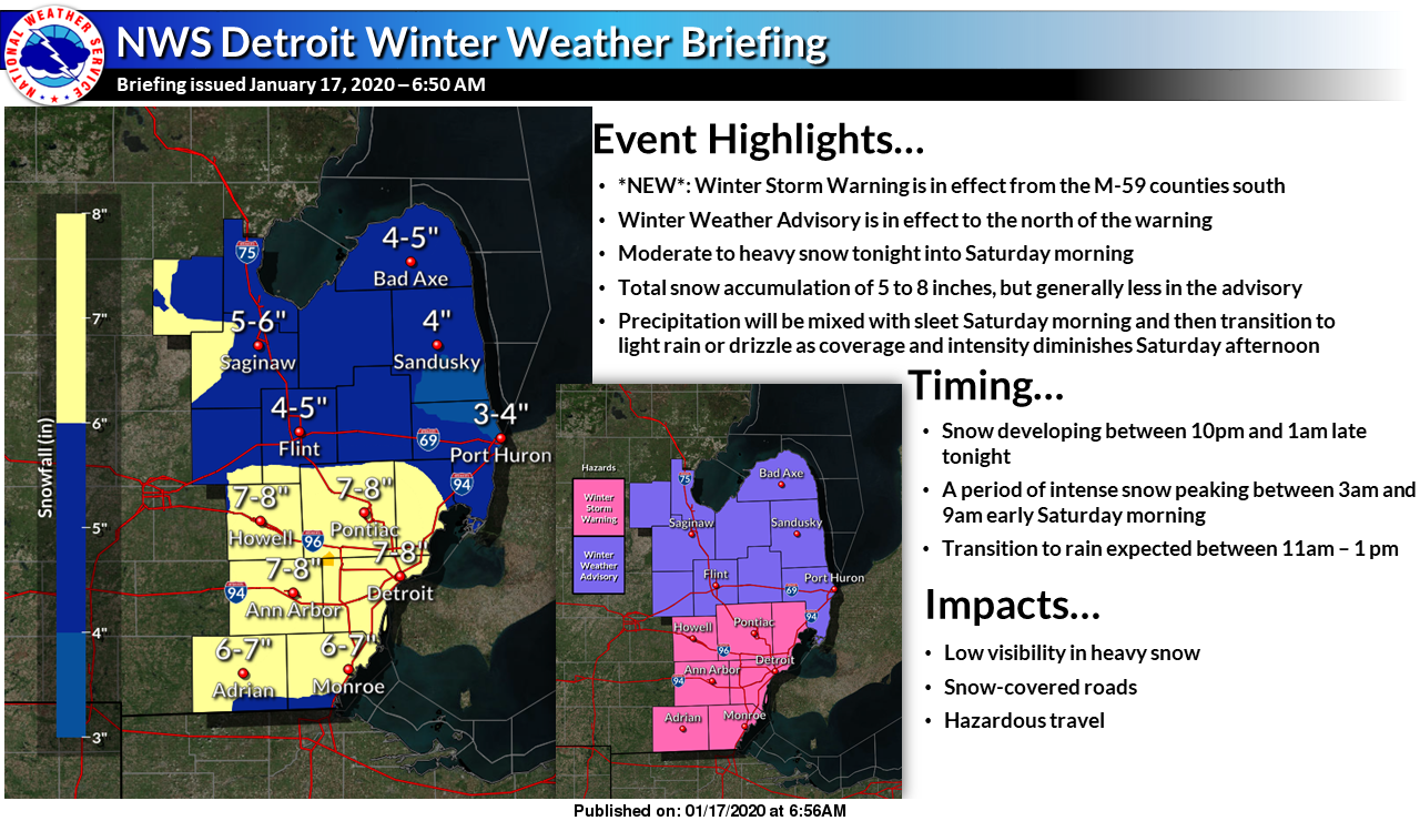
Well, here we go again, we have advisories and warnings across the state. The southeast corner has a winter storm warning. I am wondering why the Detroit office differs in their forecast when snow accumulations will be similar. I am thinking the Grand Rapids office will line up with Detroit as the storm gets closer or perhaps they believe the outcome will underperform like last week’s system.
We certainly have some cold air in place this morning with 12° in Otsego, 13 in Grand Rapids, 15 in Kalamazoo and 18 in Lansing. We had a high of 33 yesterday morning and the temps dropped off into the teens after sunset when the skies cleared. Last night was one of the few nights this winter when it was good for looking at the stars.
Here is the NWS outlook for today which I will update as needed:
[columns] [span6]

[/span6][span6]
[/span6][/columns]
The area remains on track to see a impactful snowfall tonight and
Saturday morning. With this in mind, we will be holding on to the
Winter Weather Advisory as is for this forecast package.

After a quiet day in which we just see clouds thicken up, and winds
increase a bit, a fairly robust of snow is expected to move in after
dark, and persist into Saturday. This snow will be the result of a
very strong push of moisture coming in via a 70 knot low level jet
nosing up into the area. The peak snowfall rates should come after
06z tonight and last until around, or just after 12z Saturday. We
are looking at potential inch/hour snow rates of a more wet and
heavy snow with lower snow-liquid ratios. This snow will obviously
cause issues with the roads, and could cause some power outages as
the snow could weigh down power lines and snap tree limbs.

The snow should then let up in intensity on Saturday, and will
likely even change to a wintry mix, and then rain/drizzle for areas
along and south of I-96. This happens for a couple of reasons. The
first reason is the surface low will come up into the area, and
bring a brief shot of warmer air. This will come in aloft first, and
could bring a brief bout of some freezing rain. This should not be a
problem for roads falling on top of snow.  Also, the deeper moisture
will peel away, and could end up as some drizzle as the dgz becomes
unsaturated.

-- Lake effect snow showers to affect the area Saturday night into
Monday --

Where it does change over to rain, it will be brief as the low moves
east very quickly, and colder air is quick to rush in behind the
low. This will change precipitation back to some snow, and
eventually lake effect as sufficiently cold air advects in. The flow
regime ends up as W/NW, which would favor areas toward Ludington,
and between I-96 and I-94. Additional accumulations will be expected
as the deep cold air on the cyclonic side of the upper jet will be
overhead, and overlake instability will be in the mid to upper teens
C. The lake effect potential will linger into early Monday
morning before it shifts offshore.
If you are interested in snowfall forecasts you can look at the point forecasts on the main page – at this time the heaviest snow will fall from Allegan County to the north with six-plus inches forecasted, keep in mind this is forecasted to be the heavy wet stuff humans and snowblowers alike dislike clearing. Everything on the page auto-updates through the day.
New post is up!!!
Slim
I will keep this thread up until Slim uploads his post (sorry I was offline since yesterday afternoon)
I just cleared the driveway and will post something after I have breakfast. Thanks for your help MV
Slim
3 to 6 inches of snow still to come yet this weekend for most! Incredible storm and pattern!
We have a couple inches of wet snow on the ground with a temp of 30 degrees – some rain has been mixing in.
Then it is a different world well south of town, because GR has been and is still getting pummeled!
our snow is compacted from the rain and warmer temps
What a storm and definitely should have been a warning! Get ready for the lake effect and wind! Wow!
Good morning, fellow weather nuts. We have roughly 4” on the ground and it is still coming down at a pretty good clip. Looks like the NWS was correct with the issuance of a WWA.
I am getting ready to clear the driveway I have 5.7″ here the snow sleet mix is now back to moderate snow here and it is now 27
Slim
I have just under 6″ of snow on the ground the snow is now mixing with a little sleet here and the temperature is 27 with light winds.
Slim
After the update that MV made on the site I am still not able to make my Saturday point
Slim
Sorry, I just sent you an email with the updated link – it uses https instead of http which mean that everything has security features locked in place and we have a secure site in the search engines
It’s a winter wonderland in most of west Michigan ….INDY
This storm was nothing like last weeks as the warm weather fanatics were begging for! Face the facts this a great storm and the RDB model hit another BINGO! Also INDY was spot on with his prediction of 6 to 10 inches which he made days before the storm hit! incredible!
Thank you thank you thank you!! INDY
Facts are facts unless you are a warm weather fanatic!
Great news>>>>the mini warm up the end of next week will be minimal and short lived and then Feb will be cold and snowy! I love winter so let’s see cold and snow for the next 8 weeks!
It is a winter wonderland! I love winter and lets keep it going!
http://wxcaster.com/gis-gfs-snow-overlays2.php?STATIONID=GRR
We got hammered with snow last night and are currently still getting pummeled with snow! Let it snow!
Going to switch over to rain tomorrow.. I love it ! More rain next week.. I love winter !
At this time I am unable to post my Saturday post so will have to wait until MV makes some changes
Slim
Currently we are getting pounded with snow and we have about 8 straight hours with moderate to heavy snow coming! Also the lake effect tomorrow night and Sunday is looking great for Kent County! Who knew?
http://wxcaster.com/gis-snow-overlays.php?STATIONID=GRR
Blowing over Zland lol….LET IT SNOW LET IT SNOW LET SNOW..INDY
I am sure the report from Zealand will go like this! Not that bad out, 2 or 3 inches of snow and it will melt next week! In reality a great storm and wsw worthy and great outdoor winter sports conditions starting tomorrow and lasting for many days!
The new cpc is on board for below normal temps in February and next week will be just a little above normal with snow chances! Incredible!
This is a beautiful sight!
The latest gfs model!
http://wxcaster.com/gis-gfs-snow-overlays2.php?STATIONID=GRR
Kind of odd that this storm is coming up from the Southwest when 2 days ago someone said this was the polar vortex. Did the North Pole shift out West somewhere?
Wow what a huge winter storm brewing to out Southwest on my 6th Sprite getting ready for it to snow tonight …. PARTY TIME!! INDY….
Rock n roll will never die and cold and snow is awesome! Bring it!
The new CPC is out and it looks WARM!
Wow, that A is stamped right over top of GR! Going to be a quick melt of any snow we might get. Love it!
Awesome !
With any snow we get this weekend it will be a mushy mess by the following weekend.. More Mild air and rain by then.. Still NO Polar V in sight !! Days keep getting longer and Spring just another day closer.. I love it !!
My point forecast has dropped the snowfall forecast for the main event (overnight and tomorrow morning) by nearly 30% since early this morning. Maybe we will get more rain here than originally expected.
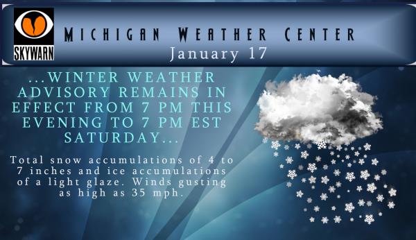
Now I know the NWS has our area in an “advisory” at this time (it should be noted we were “warned” last weekend to no avail. But (read below)
Slim
Historically there is a good case to be made for West Michigan to have a WSW (whatever happened to the old Heavy Snow Warning?) As you know what? The most daily snow fall for January 18 in Grand Rapids history is only 8” in 1960 with 6” in 1936 in 2nd place 5” in 1901 in 3rd place and just 4.4” in 1931 in 4th place. And for January 19 the record is 6.4” in 2003 then 5.6” in 1901 in 2nd place with 4.6” in 3rd place. The fact is we are now well past the average end time… Read more »
I know I am late on my thoughts today. But I am still in recovery mode from my pill swallowing issue on Wednesday. Anyway at this time the current radar looks like there is a lot of snow and sleet to our southwest (still a ways off) but in looking at ground reports in looks to be Iowa mostly light snow to snow no reports of heavy snow there yet. Nebraska some locations reported light snow with many reporting Freezing rain. Missouri some reports of snow many Freezing rain to just rain. Illinois only one location reporting snow the rest… Read more »
updated post and added radar…
I just went to the store pick up 2 dirty 30pks of Sprites 3 LG bags of ice 3 loafs of bread 2pds of lunch meat and a carton of reds …I’m thinking INDY is ready for the snowstorm…Here we go!I INDY ….
Lol
Ready to sit back and pound the Sprites tomorrow! Don’t care what happens!
Love it Andy ….Be safe buddy …INDY
Oh yeah INDY, not doing anything tomorrow or Sunday! Don’t forget INDY Michigan Hoops on tonight!
9pm baby go blue! INDY
I’m seeing more 40’s next weekend now on some of the models!
Indy said we would have some days with single digit highs coming soon. Still seeing absolutely no sign of that though. The back half of February is looking very wild.
It might just end up being a very mild winter over all this year. That may mean a “cool” summer is on its way or more likely a cold late February, March and start of April is on tap. We shall see.
Slim
Or it may mean an early and mild spring since there could be little snow/ice to reduce temps.
NWS says a Winter Weather Advisory will be sufficient for this event? Hmmm… that’s pretty weak.
At this time the low is forecasted to move from Chicago up to Alpena – should it move a bit further south there would be less rain with this system- we shall have to wait and see
8+ inches of snow coming and the NWS has GR under a winter weather advisory now thats FUNNY!! Reminds me of Zland never gets snow ….Yes FUNNY!! MV’S best Prepare now we have a major Winter storm on the horizon!! Have a super Friday….INDY…
Don’t worry Indy even if we do get 6 to 10 inches there will be some on here that will say “ not to bad, not really a snowstorm, not as bad as they predicted”, etc, etc, etc! Bring on the snow and let’s get this party rolling!
Of course then there are those who lose their minds and over hype storms like beating a dead cat repeatedly, like last week for example.
Or it’s just to get berry going lol….LET IT SNOW LET IT SNOW LET IT SNOW!! INDY!
Don’t know who that is joe.
Well, I will attempt to use my snowblower for the first time the year. However, my little single-stage unit doesn’t do very well with heavy, wet snow. May have to do it the old fashioned way: give each kid a shovel and watch them from the warmth of inside.
Ha. Build up those hockey muscles! But yeah, we were warned in October to have the snow blowers ready. 3 months later it’s still sitting in the barn and hasn’t even been fired up yet.
I would suggest blowing the snow out before the mix comes in and before it turns to an iceberg when the temps fall behind the front
Looks like we finally achieved the milestone of 1 inch of snow for January yesterday with the whole one tenth inch that fell. And it was still yet another above average day temp wise. What an incredible stretch!
Let it snow! The NAM is still bullish! The RDB forecast for GR has not changed. Get ready for weekend snowfall totals between 7 – 11 inches!
http://wxcaster.com/gis-snow-overlays2.php?STATIONID=GRR
Looks Awesome!! INDY..