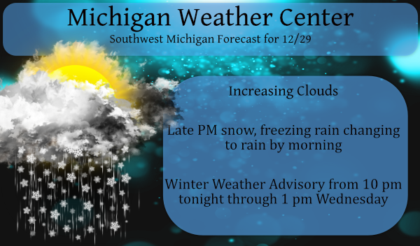
We have another winter weather advisory which will move into place at 10 pm tonight lasting through 1 pm tomorrow afternoon for a good portion of Michigan. This system will feature a mixed bag of precipitation beginning as snow, then a mix changing to all rain as we get into the early morning hours on Wednesday.
Model runs have shown conflicting data as to amounts of snow from this system, however, at this point, it appears to be a sloppy wet system in store.
We will have another system of similar attitude moving through on Friday.
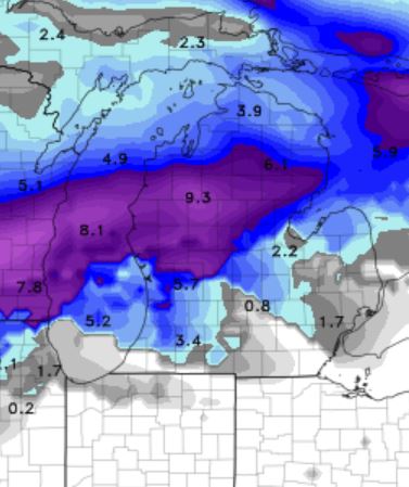
This is the NAM for snowfall guesses which I believe to be overdone, this assumes a longer-lasting snow event through the advisory period.
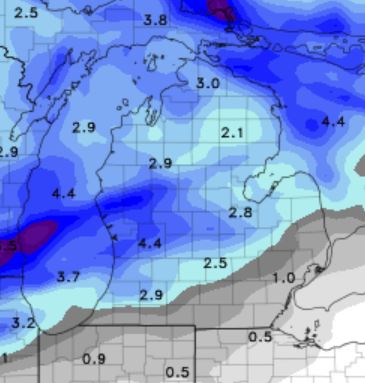
This is the GEM forecast which I believe to be a closer match to what will accumulate in the area.
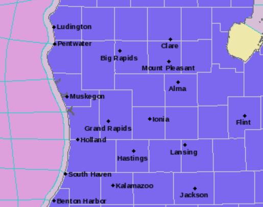
This is the NWS take on the system:
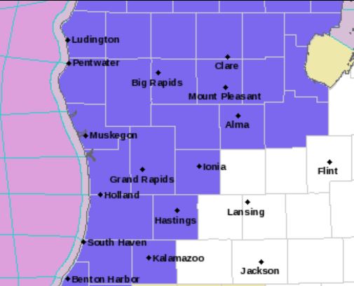
We will expand the Winter Weather Advisory to the southwest to cover the chance for some travel impacts late tonight into Wednesday morning from snow or a brief period of freezing rain. For tonight, moisture return along with increasing warm advection/isentropic ascent on the backside of departing cold surface high will bring a burst of snow spreading in from the southwest with the heaviest expected area of snow across the northwest zones.
As southerly flow continues overnight, snow will turn to freezing rain and then rain across areas along and south of I-96. The freezing rain should be limited by the combination of latent heat effects and increasing warm advection at the surface. Still, the southwest zones could have a period of icy roads during part of the morning commute.
This event has a higher than average bust potential given the nature of warm advection snows, but we do expect enough snow or mixed precipitation in the advisory area to negatively affect travel during part or all of the Wednesday morning commute. Conditions should improve by Wednesday afternoon as surface temperatures rise above freezing.
The CPC guesses warmer than normal temps to mid-month with above-normal precipitation so I would suspect similar systems through this period.
I just took a snowfall measurement and here at my house I have 2.5″ there is still some light snow falling with a temperature of 28
Slim
Plow trucks are gassed and tuned up ready to push the 6-8 feet at indys house tonight!!! Finally we getting some snow!!!!
Sprite Ehanced…feet of Snow. 🙂
What do we have here! Is it possible, could it be? The NWS is a little bullish! The latest RDB model gives GR around 2 to 3 inches! I am rooting for the NWS estimates! Who would have thought?
Latest Update:
A slightly sooner arrival of the snow is expected this evening so
the headline start time was moved up.
The winter weather advisory was expanded as well.
Impacts are expected for the Wednesday morning commute for the
remainder of the CWA. As a result we will expand the headline to
include places like Lansing and Battle Creek. Mainly snow is
expected to the north of a Holland to Grand Rapids to Alma line
where 4 to 6 inches looks likely. Further south the snow arrives
tonight with a couple inches possible. A period of freezing rain
or sleet looks likely before temperatures rise above freezing
late.
Jeez, the MDOT salt trucks are out in full force this afternoon. Making up for lost time, I guess.
I noticed that last week with our 1 inch of snow. I think they dumped 3 inches of salt on top of it. Monthly quotas to reach or next year they don’t get as much.
Well, we’ve been hearing about the coming snow and cold and vortex for over 2 months now, but the snow drought records continue to fall and be shattered. As always, it’s all just 2 weeks away. Just like 2 weeks ago.
I just looked at last nights EWMWF (European) long range guess for the next 4 weeks and that model also has it wet and mild well into January. So I do not expect it to turn real cold in the first half of January and maybe beyond. We shall see. That is not to say we will have have any snow as it can snow with temperatures in the low 30’s that is for sure. And I am concerned about ice on Friday of this week.
Slim
Looking more and more like my area maybe in the sweet spot for heavy snow over night could it be 7 or 8 inches now stay tuned… Quick thought look at the winter storm warnings across the lake lined right up with west Michigan that could be the sign..INDY
I noticed that late last night too. I was wondering if it will move our direction.
Sure would be nice if it is going to be cold to have a little snow to go out and play in. LOL!!!
The CFSv2 long range guess continues to show warm temperatures well into January.
Slim
First two weeks are looking warm. It is possible things cool down for the second half of the month… too early to know. But we will have a lot of catch up in the snowfall department for the second half of winter.
Possible polar vortex breaks away around the 10th or so of January has been the talk In the last couple days if that’s the case look out west Michigan …INDY
There has been talk of that and that is something to keep an eye on.
Slim
WINTER WEATHER ADVISORY GREATTTTT SCOTTY we could easily see 6+ inches here in my area get the snow shovels ready!! Have a super Tuesday let it snow…..INDY
I am sure that there will still be snow this winter season. There is now way that Grand Rapids will end this winter with less than 35″ of snow. But we shall see.
Slim
It has not gotten below zero in Grand Rapids since February 1, 2019 and the low for this year will be +4 and that will be the 4th warmest minimum of any year in recorded history at Grand Rapids. The warmest annual minimum was +8 in 1921. The 2nd warmest was +7 in 1931 and in 3rd place is +6 in 1937 and 1939. Also, of note the last time Grand Rapids had 10” or more of snow on the ground was on February 2nd 2019. With just 3 days to go the total snow fall this year (January to… Read more »
Well, I’ll be darned. Looks like snow is on it’s way. Local met just said we may get two inches. 40 and turning to rain tomorrow, so the shovel may continue to collect dust.
You know I am kind of liking this winter so far. It is kind of like moving about 500 miles to the south without moving. I am afraid that come late winter into spring we might have to pay for this.
Slim