A lot of stuff going on in the weather today and tomorrow after our dry period we are now in the midst of an active weather pattern. We have seen 1.93 of rain since yesterday which could have been over a foot of snow if we would have been on the cold side of the system we are in now.
We have 41.7° currently at 6am falling from a high of 50° at midnight. Yesterday we reached 54.7° (these are all Otsego readings.)
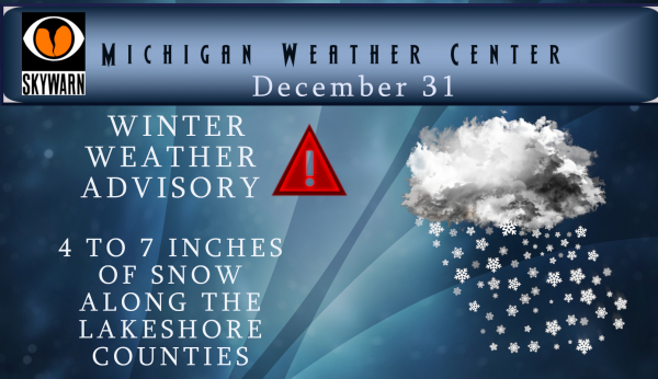
We have a Winter Weather Advisory until 7pm Tuesday for the following counties:
Mason-Lake-Oceana-Newaygo-Muskegon-Ottawa-Kent-Allegan-Barry- Van Buren & Kalamazoo
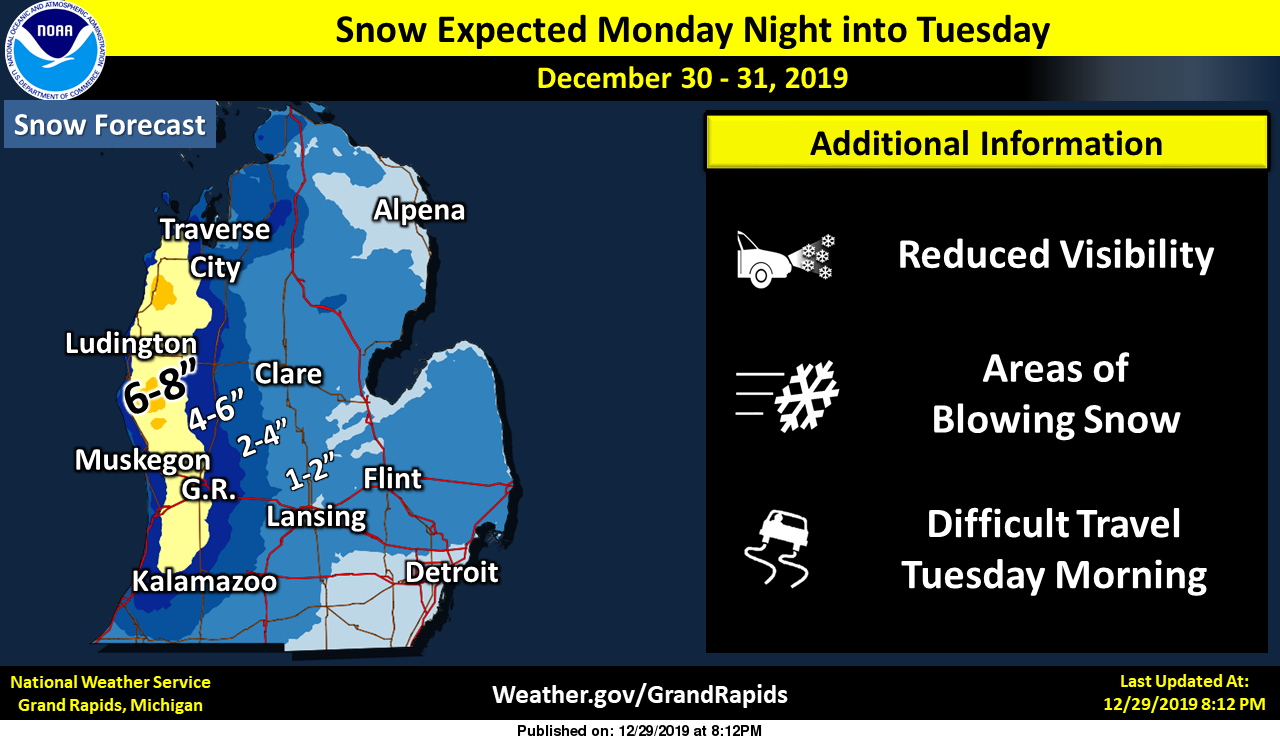
Snow is expected tonight into Tuesday. Most of the 4 to 7 inches that are expected will fall between midnight and sunrise Tuesday. Snow showers will continue into New Years Eve however with some additional accumulation. Winds will become gusty by mid morning across the area. Some gusts could reach as high as 50 mph even well inland of the lake shore. The strongest wind gusts are expected during the mid morning into early afternoon hours. Even so gusts to 40 mph are expected to continue into Tuesday morning.
Osceola-Clare-Mecosta-Isabella-Montcalm-Gratiot-Ionia-Clinton- Eaton-Ingham-Calhoun- &Jackson counties:
Snow is expected late tonight into Tuesday. Most of the 1 to 3 inches that are expected will fall between midnight and sunrise Tuesday. Snow showers will continue into New Years Eve however with some additional limited additional accumulation. Winds will become gusty by mid morning across the area. Some gusts could reach as high as 50 mph even well inland of the lake shore. The strongest wind gusts are expected during the mid morning into early afternoon hours. Even so gusts to 40 mph are expected to continue into Tuesday morning.
[columns] [span6]
[/span6][span6]
[/span6][/columns]
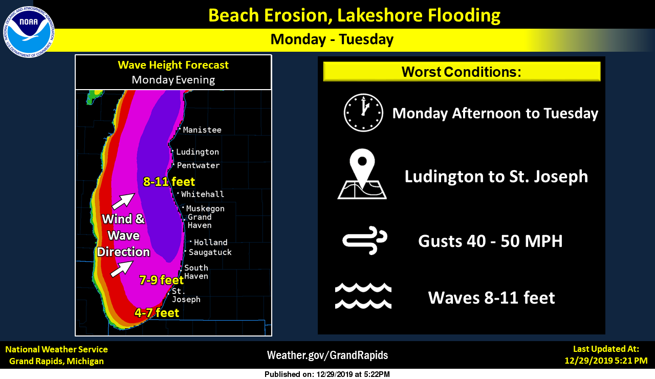
We have wind advisories for the east side of the state and lakeshore flood advisories along the Lake Michigan coastline.
Wind gusts to 50 mph today and to 40 mph tonight may result in some travel problems for high profile vehicles. Some power outages are possible. Snow showers will be come widespread early tonight, first near and west of US-131 then they will spread inland by midnight.
The snow showers will be locally heavy near and west of US-131 during the early morning hours of Tuesday. the combination of the snow and gusty winds will create blowing and drifting snow. Some roads may be icy as temperatures are expected to fall below freezing tonight. All of these issues will create challenging driving condition during the early morning hours of Tuesday.
Be careful out there! It has been a while since we have had accumulating snow. I have to drive to Kalamazoo in the morning so I imagine I will get to join in the party. Thursday and Friday we will see temps back in the 40s before falling back to more seasonal temps….
here is the link to the Consumers Power outage map...
Happy New Year, my fellow weather fanatics!
Trending up! Bring it! Have a safe New Years!
https://www.instantweathermaps.com/GFS-php/conussfc.php?run=2019123118&time=PER&var=ASNOWI&hour=384
🤣
What a joke! If Rocky’s maps were correct we’d have 8 feet of snow in GR by now! Temps in the 40’s this weekend! MELT! MELT!! MELT!!!!!
MV best of luck to your wife with her shoulder surgery. Sandy
That was a good 4-6 inches across the Grand Rapids area.. Most of it came between 3 and 5 this morning. It was very wet and heavy… Now we wait till the next one..
What a good 6 inches? How is that possible? The warm weather fanatics will tell you it wasn’t much of a storm! In reality that was a monster storm and the roads were horrendous and very dangerous! Who knew?
The WWA has been cancelled. We have about 2” now.
Makes sense, really nothing since early this morning except a few flurries.
Only the beginning…
On a side note, it sounds as though the UP is in very bad shape this morning 🙁
Keep it rocking!
It is a winter wonderland out there! Enjoy because there will be a lot more where that came from! I love it! What a storm!!!!!
Cleaned off the driveway and snow depth on it was anywhere from an inch to 3 or 4, but with the warm ground it is melting a lot underneath so I used the mower with a plow. Snowblower would not be very effective with the heavy slop, so it is still in the barn going into January. Guessing an inch or more has already melted at ground level, so total her would be maybe 4 or 5 inches. Certainly nothing to get excited about especially since it’ll be gone in 2 days.
December will end with below average snow and much above average temps. Currently GR is +4.1 degrees above average for the month.
Enjoy your 1 day of winter. Things will be melting come Wednesday, Thursday, and Friday. Low to mid 40’s and rain? Wow! The mild temps just won’t stop.
This just in! My updated official snowfall measurement on the north side of Rockford is a whopping 6.5 inches. Are there any other snowfall totals from the GR area? It sounds like Slims best estimate is 5 inches! I have a feeling we will hear about some 7 to 8 inch totals! What a storm!!!!
Took several snow fall measurements and came up with a average of 5″ on the ground with a range of 1″ to just over 8″ so a rather good snow fall to end the month and year. At this time it is 28 and some light snow still falling.
Slim
MV Best of luck with your wife’s surgery.
Slim
Just drove into kalamzoo, roads are slick but passable . Wife is having shoulder surgery this morning . Snow is beginning to wind down…
Best of luck to your better half. Safe travels.
Check out this 5 day snow map!
http://wxcaster.com/gis-gfs-snow-overlays2.php?STATIONID=GRR
Wow what a storm. 4 inches and counting! We are still getting hammered with snow and our point forecast says another couple inches are on the way! The wind, cold and snow is incredible! Next week looks great also! Winter is starting to get revved up! Get prepared now!
After reviewing the snowfall reports, it appears that NWS GR nailed another forecast. We have just about an inch here.
Snowing very hard out at thee YARDofBRICKS NE of GR the ground is covered roads are slippery looks like a Winter Wonderland…Stay tuned…INDY
HEAVY SNOW MOVING IN! INDY
We are getting plastered with snow as we speak! Let’s keep it rocking all night long!
Put this in your pipe and smoke it WZZM!
29* degrees out at thee YARDofBRICKS NE of GR feels like 20* degrees with the wind …I’m thinking what snow falls will be sticking not melting tonight …It’s cold outside…INDY
I will keep this thread going through a least tomorrow afternoon, not much should change as the advisory lasts through tomorrow evening.
high for today was 50.5 at midnight with rain – currently 31.6 with light snow (5pm)
Wow channel 13 really went out on a limb at noon and now saying only 3 inches when everyone else is 3-7 plus… Let the guessing games begin!!!! Happy plowing everyone!!!
Wzzzm is terrible especially now after firing Arron A. I’m done watching them….Give 4-7 some 8+ inches a good bet especially in the Kent Newaygo Muskegon Ottawa and Allagan area center ….INDY
Love the attitude, u and Rocky should plow snow for living.. You guys would keep the moral up when everyone is getting tired lol.. Yeah kinda crazy Alaina and Aaron both leaving, somthing must be going on there.
Lol yes we love the cold and snow I believe new manager taking over …I hope you get some good plowing in tomorrow be safe ..INDY
Rock on Wild Bill and I thought about snow plowing in the winter! As for wzzm, they are off of their rockers! That is a horrible forecast!
You know it! Keep up the good work!
6pm WZZM said 4-6” for GR area
More potential snow for next week!!!
https://www.instantweathermaps.com/GFS-php/conussfc.php?run=2019123012&time=PER&var=ASNOWI&hour=384
Great Snow! Keep it coming ROCKY! INDY
🤣
Time to get out the sleds!!
The gfs looks better.
http://wxcaster.com/gis-gfs-snow-overlays.php?STATIONID=GRR
That map generally shows 2x the actual snowfall amount. Given that, it would appear that NWS GR is spot on with their forecast.
Not always, in fact there has already been one or two storms this year and the GFS snow model was spot on! Bring it!
Well, we will find out tomorrow if Kalkaska gets 15” and GR gets 8”.
37° with some breaks in the cloud cover. Still some what windy.
Slim
Ck out the latest NAM
http://wxcaster.com/gis-snow-overlays.php?STATIONID=GRR
Looks great for me. 🙂
Looks a lot better for me now too!! I’m solidly in the 2 to 3 inch area!
Currently 34* degrees out at thee YARDofBRICKS NE of GR with snow showers and wind boy that temp has dropped fast …INDY..
berrry good!
I just took a look at temperatures to our west. Well yes there is some snow to our west and while colder then it has been there still is no real cold air to the west so the snow that falls today will fall in above 32° temperatures and a warm early November like ground temperature so bosom line not much snow for today that will stay on the ground. as for tonight? Still too early to say for sure.
Slim
High temps for the rest of the week are forecasted to be above freezing/average.
Yeah all the warm weather has really warmed the ground for this time of year. Whatever falls will begin melting immediately followed by mild temps in a few days, not going to last long.
Over 3 thousand people with out Power already in Kent county this storm is intensifying as we speak we are officially on the cold side of it now temp is 38* now and falling out at thee YARDofBRICKS NE of GR …stay safe …INDY
Grand Rapids is now over 50” of precipitation for the year. With todays high of 50 already reached December 2019 will end up being one of the top warmest December’s at Grand Rapids. Will have to wait to see what the finial totals in rain and snow will be. At this time it is very windy here with a temperature of 39° As for the snow tonight we will have to see how that plays out.
Slim
Temps are crashing fast outside we are getting a wintery mix now and the winds are cranking I clocked a 53 mph gusts a few minutes ago wind chills will be in the 20’s today bundle up if your outside …INDY
Just read this, what in the heck is anyone doing on the ice with the weather we’ve had? Unbelievable.
https://www.mlive.com/news/grand-rapids/2019/12/ice-fisherman-rescued-after-falling-through-ice-on-kent-county-lake.html
A pickup went through the ice in the UP. Mlive had the story with video.
Fools….
Another astounding day yesterday with regards to departure from average at +22. Today will be similar with the high today around 50. Be great if every December was like this one or last years.
BREAKING NOW ….1 inch per hour snowfall rates coming this afternoon into this evening blizzard conditions for west Michigan pre pare now if you will be out on the roads very hazardous winter weather coming!!! INDY
Breaking news – this just in to the Weather Center>>>>>>>>>>the latest 6Z RDB model gives the GGR area 5 to 8 inches of snow with substantial drifting! We have an incredible storm on the way! This is just the tip of the iceberg, as this winter will be rocking! I say bring it on and let the rock n roll party begin!
INDY is locked and loaded ready to roll with it! somebody let mokkiee know the plan is fired up ready to head south lol ..INDY
Yes and there a few people on here that will not embrace winter; they will complain about the weather and about other posters and then not admit when a snowstorm actually hits! Incredible!
Looks like a monster storm and then after a brief mini warm up we are right back to near to below normal temps with a lot of snow chances next week! Remember the week of January 6th will be very wintry! Get ready!
Brief warm up is even cooling off now which was a high of 45* for Friday is only 40* now and seeing highs only in the 20’s next week goes to show you you can’t rely on Yahoo Accu weather lol…. This will send some packing away …LOVE IT ….INDDY!!
1.06” or rain overnight for a 2 day total of 1.76” to push the record total higher for the year. Kind of odd they started the advisory this morning when it’s 50 degrees and raining. Won’t even be cold enough to snow till later tonight, guess they’re just desperate to issue something. Looks like a short lived event then right back into the 40’s to melt the snow away again.
My local met this morning said that NWS had already planned on a wind advisory and then a WWA for us, but they decided just to incorporate the wind advisory into the WWA. He said that we will only get an inch in most areas, maybe two. The lakeshore should get some healthy lake effect, though.
Makes sense. Lake effect is always highly variable depending on wind direction and speed. One place will get a lot and a mile away will get very little. Add higher winds into the mix and then a lot of it blows further inland and starts coming down around Hudsonville to Jenison.
And remember the lake is very warm for this time of year so this could be more like a November event with more rain at the lake shore but I am not 100% convinced how this will play out. There is a lot that could change and this could end up being a large bust on snow fall amounts. I would almost think that if the NWS was convinced this would play out with the snow and wind they would have a WSW instead of a advisory.
Slim
This is more than just lake effect! We have a lot of dynamics in place, so this will be a combo of lake enhanced, lake affect and synoptic! Sounds perfect!
Sounds like the making of a blizzard to me ….Don’t forget the winds it’s cranking out there as of now …..INDY!!
Good morning from thee wet YARDofBRICKS NE of GR what a busy night tracking another major storm into west Michigan the best is yet to come 4-7 inches of snow yes IWS weather page will racking stacking and tracking all day this is why we love weather in West Michigan snow away ..I’m going outside to sharpen the snow shovel up have a great Monday INDY!!
My snowblower is getting excited!
Sounds good and the RDB is actually showing a little more snow that that!