We have 8° at 6 am this morning with more snow on the way. My furnace went out overnight, of course, the coldest air of the season is here while it decided to go on sabbatical. Luckily we have alternative sources of heat to get us by until we get a repair person here.
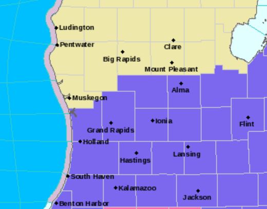
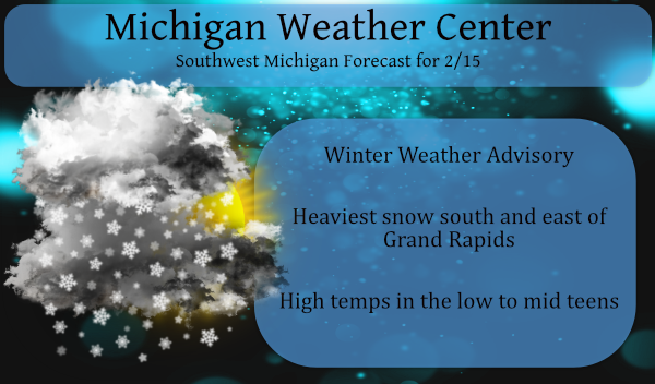
The Winter Weather Advisory is in place until noon tomorrow.
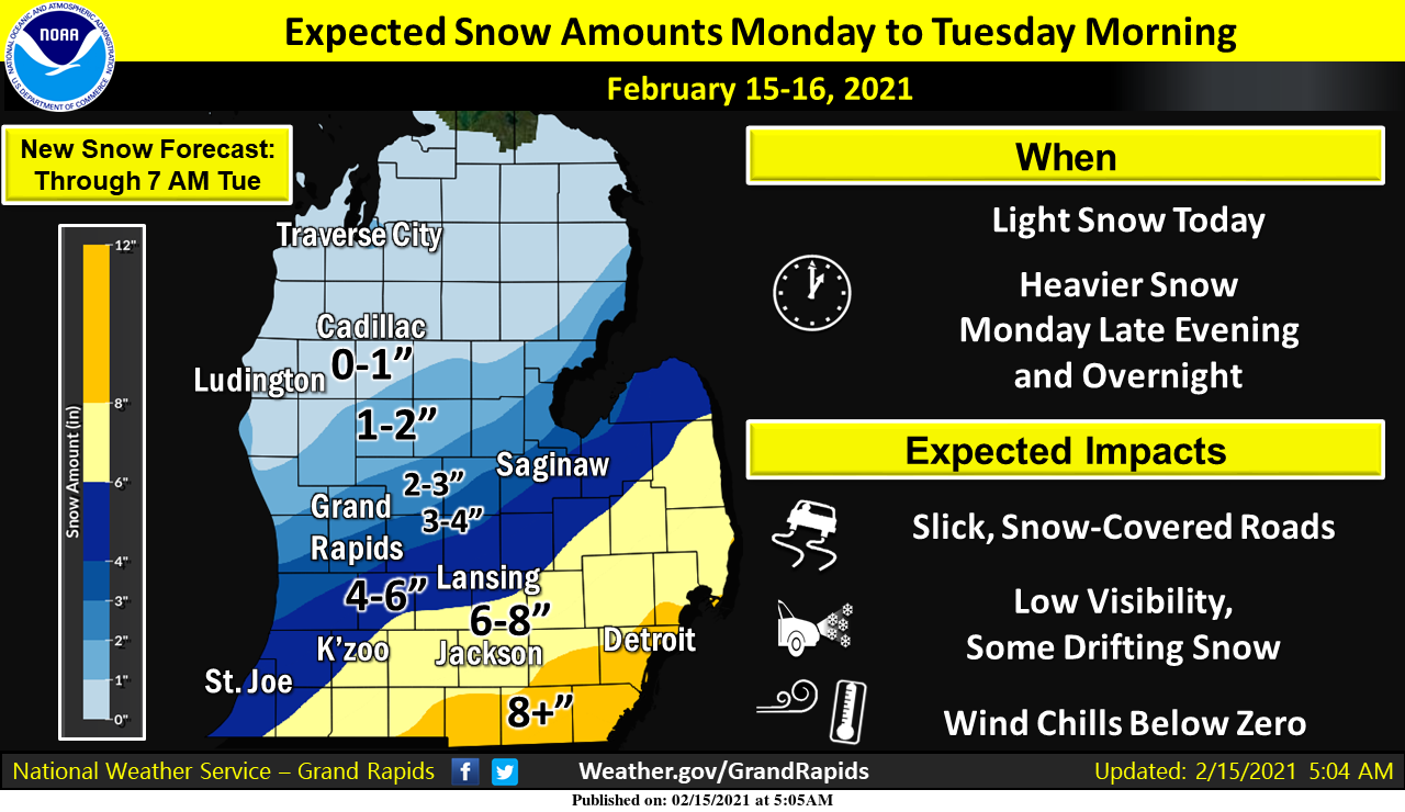
We have a storm system heading towards us, Expect light snow during the day with some lulls, then heavier snow arrives from south to north during the evening. Travel overnight into Tuesday morning will be difficult in southern to southeastern Michigan. Be prepared for cold temperatures topping out around 12-15 degrees this afternoon, then falling to around zero tonight. The heaviest snow is predicted to be south and east of Grand Rapids.
Snowing hard by my place. Hoping for good roads tomorrow.
Definitely could be a winter storm warning here in my area we are getting hammered right now lots of schools closed coming tomorrow let it snow let it snow let it snow..INDY
I am rooting for the NAM model! In the NAM we trust! Check this out!
http://wxcaster.com/gis-snow-overlays2.php?STATIONID=GRR
Impressive amount of snow!
What more snow ?? No way ….Let it snow let it snow let it snow let it snow let it snow! INDY
This is a great back loaded winter! Way above normal for Feb snowfall and counting! Rock n roll will never die!
I say 1 to 32 inches of snow overnight! I am always 100 percent accurate!
Way to go out on a limb! The RDB model has been spot on this year! Who would have thought?
Latest advisory for GR at 2:20 calls for 4-7 inches. Not even including the storm on Thursday!
Sounds very promising and with any luck it will travel even farther to the West and absolutely hammer us! Bring it!
>>>>>>Breaking Weather Alert>>>>>12z RDB model shows the deformation zone tracks a little farther Northwest, so GR get ready for 4 to 7 inches on Snow! Areas to the southeast will see even more snow! Snow, cold, wind and bad driving conditions tonight and Tuesday morning! Get prepared now! Rock it out!
Under the 7-day forecast for Lansing, NWS GR upped the snowfall amount for tonight from 5″ this morning to 6″ at noontime. Plus: “We are considering upgrading a few counties in the I-69 area to a Winter Storm Warning since it now seems snowfall amounts, gusty winds and low wind chills will all be factors in this storm tonight.”
Looks like we may get 6+” tonight. I will be firing up the snowblower for the fourth time this season, which is 2x as many as last season.
Sounds great!
With just over inch of new snow fall here over night I now have 12.2″ of snow on the ground. The sun has just came out here and the current temperature is now at 12° I had a over night low of 9. Officially at GRR the seasons snow fall is now at 35.8″ As of yesterday the officially there was 10″ of snow on the ground.
Slim
We picked up another .5 of an inch of snow overnight bringing our total to 30″. We need 10 more inches to beat last year’s total. Low overnight was 8.1 degrees.
Yesterday Barry asked about the annual average snow fall reported for Holland. The numbers I had in my post on Saturday were from a 3rd party and are correct in respect to the years 1914 to 1942 with a break and a repeat from 1944 to 1975. I just checked and for all the years that there have been snow fall reports for Holland the annual mean is 73.4” The most snow fall is 159.9” in 1969/70 and the least was a reported 20.0” in the winter of 1932/33. During the same time period at Grand Rapids the mean was… Read more »
Thanks Slim!
Enjoy this great winter weather. The warm up next week will be brief, so get ready for more snow!!
Just more fake news and wishcasting from Rocky!
https://weather.com/weather/tenday/l/b4ea0280869baa46799dc75eacef8904785ec43ad2f6fb098355fbc208a55e2c
https://www.accuweather.com/en/us/rockford/49341/daily-weather-forecast/2211654?page=1
Lol we will not see 40 degrees! Maybe more like after a few mid to upper 30’s back down to around freezing or a little below! Mark it down!
Sorry to hear about your furnace MV. I still remember when ours went out in January of 1994. I had to use the oven (I know you are not supposed to do that but hey it helps) I also had a couple space heaters and one more thing that helps is full the bath tub up with hot water.
Slim
We have an Amish fireplace which makes a great backup. I believe we have to have the thermocouple replaced – not one of those things one can run to the hardware to get a new one…
..Over 150 million Americans are currently under Winter Storm Warnings, Ice Storm Warnings, Winter Storm Watches, or Winter Weather Advisories as impactful winter weather continues from coast-to-coast… …Major winter storm to spread heavy snow and significant ice accumulations from the Southern Plains and Ohio Valley to the Northeast… …Additional winter weather is expected for the Northwest this morning, spreading south and east through Tuesday… …Frigid Arctic air and dangerously cold wind chills to persist in the Heartland through a good part of the week… …Severe thunderstorms, heavy rain, and warm temperatures are expected for southern Georgia and Florida… An unprecedented… Read more »
NWS talking about pattern change and mild temps above freezing starting Sunday. This short winter is just about over!
Ugh, sorry MV. It’s frustrating when the furnace goes out – especially since there are so few parts in a furnace. It is a pretty simple piece of machinery.
Two new inches of snow this morning. The local met says 4-5” tonight for the Lansing area and upwards of 9” to the south and east.
Stay warm and safe, mi amigos.
Multiple snow events this week! Who wouldn’t love back loaded winters? I love it!
http://wxcaster.com/gis-gfs-snow-overlays2.php?STATIONID=GRR
Nice 10 day map!
https://www.instantweathermaps.com/GFS-php/conussfc.php?run=2021021506&time=PER&var=ASNOWI&hour=240
Another winter weather advisory how could that be?? Doesn’t scare me away on off for weeks from this blog lol…I’m coming on here again to say let it snow let it snow can’t make this up!! Have a good Monday INDY ..
Rock n roll!!!!!