As you read in Slims post yesterday today is the anniversary of the sinking of the SS Edmund Fitzgerald in 1975 which is the largest ship which sunk in the Great Lakes and was immortalized by Gordon Lightfoot in his 1976 ballad “The Wreck of the Edmund Fitzgerald”.
[kad_youtube url=”https://youtu.be/9vST6hVRj2A” maxwidth=500 ]
While the great lakes can be hazardous to ships during storms, instrumentation has improved greatly since the 1970s and earlier days when so many ships and lives were lost.
With winter coming on it is time to look at winter weather hazards which affect us land lubbers who tend to forget how to survive when the snow is falling.
Winter Weather Basics
A winter storm is an event in which the main types of precipitation are snow, sleet or freezing rain.
- Why can winter storms be so dangerous?
- Most deaths from winter storms are not directly related to the storm itself.
- People die in traffic accidents on icy roads.
- People die of heart attacks while shoveling snow.
- People die of hypothermia from prolonged exposure to cold.
Everyone is potentially at risk during winter storms. The actual threat to you depends on your specific situation. Recent observations show that:
- Of injuries related to ice and snow:
- About 70% occur in automobiles.
- About 25% are people caught out in the storm.
- Majority are males over 40 years old.
- Of injuries related to exposure to cold:
- 50% are people over 60 years old.
- Over 75% are males.
- About 20% occur in the home.
- How do winter storms form?
- Just like any other storm at other times of the year, the right combination of ingredients is necessary for a winter storm to develop.
Three basic ingredients are necessary to make a winter storm:
- Cold air. Below freezing temperatures in the clouds and near the ground are necessary to make snow and/or ice.
- Lift. Something to raise the moist air to form the clouds and cause precipitation. An example of lift is warm air colliding with cold air and being forced to rise over the cold dome. The boundary between the warm and cold air masses is called a front. Another example of lift is air flowing up a mountainside.
- Moisture. To form clouds and precipitation. Air blowing across a body of water, such as a large lake or the ocean, is an excellent source of moisture.
Types of Winter Weather
Winter storms
A winter storm is a combination of heavy snow, blowing snow and/or dangerous wind chills. A winter storm is life-threatening.
Blizzards are dangerous winter storms that are a combination of blowing snow and wind resulting in very low visibilities. While heavy snowfalls and severe cold often accompany blizzards, they are not required. Sometimes strong winds pick up snow that has already fallen, creating a ground blizzard.
An ice storm is a storm which results in the accumulation of at least .25” of ice on exposed surfaces. They create hazardous driving and walking conditions. Tree branches and powerlines can easily snap under the weight of the ice.
Lake effect storms are not low pressure system storms. As a cold, dry air mass moves over the Great Lakes regions, the air picks up lots of moisture from the Great Lakes. This air, now full of water, dumps the water as snow in areas generally to the south and east of the lakes.
Snow squalls are brief, intense snow showers accompanied by strong, gusty winds. Accumulation may be significant. Snow squalls are best known in the Great Lakes region.
Types of Winter Precipitation
Snow
Most precipitation that forms in wintertime clouds starts out as snow because the top layer of the storm is usually cold enough to create snowflakes. Snowflakes are just collections of ice crystals that cling to each other as they fall toward the ground. Precipitation continues to fall as snow when the temperature remains at or below 0 degrees Celsius from the cloud base to the ground.
- Snow Flurries. Light snow falling for short durations. No accumulation or light dusting is all that is expected.
- Snow Showers. Snow falling at varying intensities for brief periods of time. Some accumulation is possible.
- Snow Squalls. Brief, intense snow showers accompanied by strong, gusty winds. Accumulation may be significant. Snow squalls are best known in the Great Lakes Region.
- Blowing Snow. Wind-driven snow that reduces visibility and causes significant drifting. Blowing snow may be snow that is falling and/or loose snow on the ground picked up by the wind.
- Blizzards. Winds over 35mph with snow and blowing snow, reducing visibility to 1/4 mile or less for at least 3 hours.
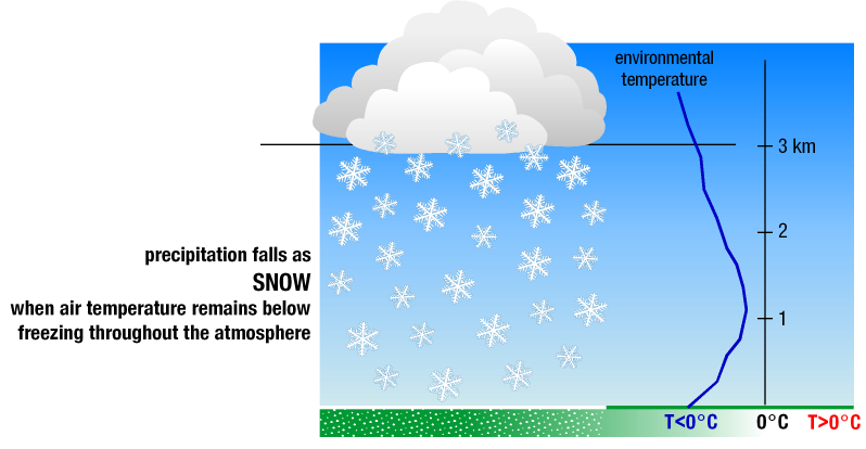
Precipitation falls as snow when the temperature remains at or below 0 degrees Celsius from the cloud base to the ground. [+]
Sleet
Sleet occurs when snowflakes only partially melt when they fall through a shallow layer of warm air. These slushy drops refreeze as they next fall through a deep layer of freezing air above the surface, and eventually reach the ground as frozen rain drops that bounce on impact.
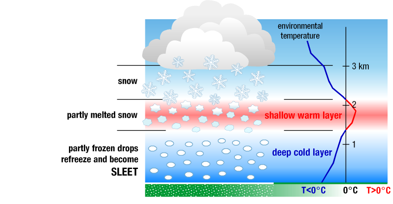
Sleet falls when snowflakes partially melt as they fall, and then refreeze before they reach the ground. [+]
Freezing Rain
Freezing rain occurs when snowflakes descend into a warmer layer of air and melt completely. When these liquid water drops fall through another thin layer of freezing air just above the surface, they don’t have enough time to refreeze before reaching the ground. Because they are “supercooled,” they instantly refreeze upon contact with anything that that is at or below 0 degrees C, creating a glaze of ice on the ground, trees, power lines, or other objects. A significant accumulation of freezing rain lasting several hours or more is called an ice storm.
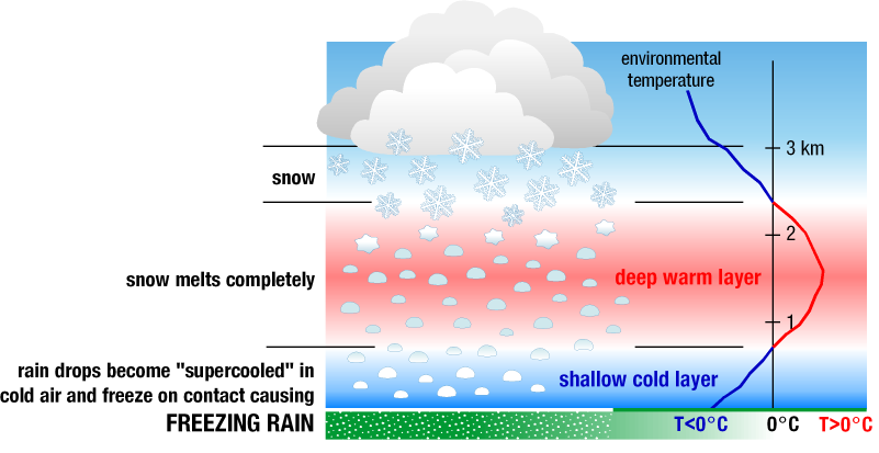
Freezing rain falls when snowflakes melt completely before reaching the surface, and refreeze upon contact with anything that is at or below 0 degrees C. [+]
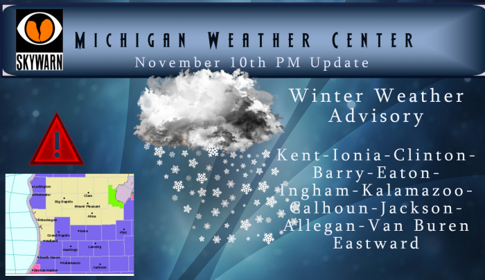
Below is the NWS take on chances of accumulating snow for tonight and Monday:
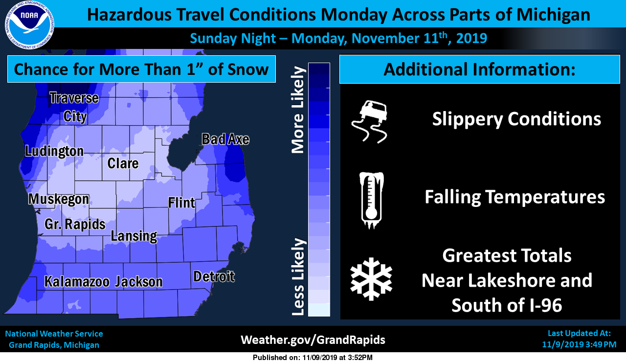
The heaviest snow will be over the Big and Little Sable points and extreme western Allegan and Van Buren Counties. We could see isolated locations in extreme western Van Buren county getting over a foot of snow. The Arctic air moving into the area could be record setting for early November. There are no advisories as of yet however this may change later today.
Incredible!!
http://wxcaster.com/gis-gfs-snow-overlays2.php?STATIONID=GRR
Record Snow Record Cold and it’s only November 8th crazzy …INDY
You can’t even get the date right?
What a storm and a great start to winter! Incredible!
Let’s hope the GFS is accurate! I am assuming some snow will melt and settle initially, which is why those totals may be a little too high. But I still have high hopes.
The great news just keeps coming!https://www.instantweathermaps.com/GFS-php/conussfc.php?run=2019111018&time=PER&var=ASNOWI&hour=384
Early November and already 2 wwa’s! Incredible! This could be a record setting winter!
Another WWA! What an incredible start to our snow season and record cold after that! Rock n roll will never die!
Yes, incredible start being around 1 inch total for the season, which is both below average and behind last year when we had about 5” by now. And don’t forget our first WWA which yielded 0.1” of snow. Incredible!
Lol…let it snow let it snow let it Snow…INDY
You know it and the naysayers will be saying winter looks mild with less snow even after we end up with above-normal snowfall just like last year! What a joke!
Keep the facts up Barry .. After the early week cold looks like not much snow in sight.. Heck ya !!
I know the NWS has mentioned about record cold maximums for the next few days here are the top 3 for Monday and Tuesday. For Monday 1. 30° in 1950 2. 31° in 1984 3. 32° in 1926. and for Tuesday 1. 27° in 1920 and again in 1894 and 3. 28 in 1996. As for the record lows it is 1. 18 in 1987 2. 19 in 2017 and 3. 19 in 1976 for Monday and for Tuesday it is 1. 15 in 1986 and 1911 and 3. 16 in 1976.
Slim
Good Morning! The official H/L here at Grand Rapids yesterday was 43/35 the sun came out at times and it was a rather nice November day. The overnight low at here at my house was 38 and it was 39 at the airport. Here in the GR area we do not look to get a lot of snow out of this cold shot as we are in the wrong location and the wind will be out or the wrong direction. But one has to remember the average H/L for today is now 50/35 so snow is not a big item… Read more »