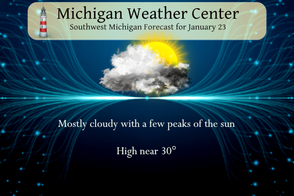
We have another inch to add to our winter’s snowfall. We have had 45.4 inches since the 1st of November and our first snowfall for January. A few leftover flurries or freezing drizzle will end this morning, so watch out for some slick bridges and overpasses early on. Otherwise, dry conditions are expected today with perhaps some peaks of sun this afternoon. Widespread snow moves into southern Lower Michigan Wednesday with travel impacts expected.
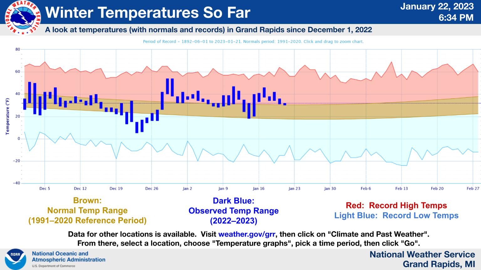
Here’s a look at Grand Rapids temps since Dec 1, along with daily normals and records. Graphs for other locations are also available (see bottom of image). Normal temps are coldest on Jan 25 (normal low of 17°, normal high of 30°). The period of cold temps in late Dec 2022 is shown, along with the stretch of mild temps in Jan so far. Looking ahead, the week of Jan 29 brings a good likelihood of below-normal temps (not shown here).
Wednesday Snow

Snow moves into the state for Wednesday with the southern portion of the Lower Peninsula slated to receive the highest totals, where odds for 4″ or more are greatest. Travel conditions will deteriorate on Wednesday with snow-covered and slippery roads developing. Expect delays for the Wednesday evening commute.
Grand Rapids Forecasts
7-Day Forecast 42.96°N 85.67°W 1 23 grrLansing Forecast
7-Day Forecast 42.71°N 84.57°W 1 23 lanKalamazoo Forecast
7-Day Forecast 42.29°N 85.58°W 1 23 kzoForecast Discussion
- Light snow tonight -

An upper level system and cold front moving across the northern
Great Lakes region tonight will bring a brief period of lake
enhanced synoptic light snow this evening/overnight. The steadiest
light snow will occur northwest of KGRR where accumulations of
around an inch or less are expected.

- Snow likely Wednesday -

A consensus blend of latest short to medium range guidance
and ensembles continues to suggest that a low pressure system
over the OH Valley region by midday Wed will move ne to near KBUF
by 06Z Thur. This would keep the swath of heavier synoptic snow
mostly southeast of our fcst area and is the most likely outcome.

Nevertheless snow accumulations on the order of 1 to 5 inches are
expected Wednesday with relatively highest amounts in that range
focused over our se fcst area. Will need to monitor guidance
trends closely as a shift even slightly further nw with this
system would bring potential for higher snowfall totals in excess
of six inches into our se fcst area. At this time we continue to
favor the latest deterministic ecmwf and ecmwf ensembles which
have been quite consistent in showing the axis of heaviest snow
will stay se of our area.

- Late week snow showers -

Some light nw flow lake effect snow showers are expected
Thursday as h8 temps fall to -12 to -14 C. After that a clipper
system will bring potential for more synoptic snow Friday followed
by lake effect snow showers on the back side of the system Friday
night into Saturday.
Breaking>>>>> snow, snow snow!
Utqiagvik, Alaska, formerly known as Barrow, Finally saw the sun rise today in over 60 days.
Of cities in the US with a population of 100,000 or greater, Grand Rapids ranks 4th cloudiest. The cloudiest is Anchorage, Alaska followed by Pittsburg, PA which I thought was interesting and 3rd was Syracuse, NY which isn’t surprising.
Interesting!
From Mark Torregrossa:
https://www.mlive.com/weather/2023/01/mid-week-snowstorm-probably-taking-aim-at-detroit-ann-arbor-parts-of-southeast-michigan.html
https://www.mlive.com/weather/2023/01/winter-roaring-back-3-snowstorms-possible-in-michigan-before-end-of-january.html
What? We are changing to winter, cold and snowy pattern! Who knew? bring it on!
Currently 26 degrees windchill feels like 17 degrees outside pretty warm lol.. Out in my hood keep that ice making a going im ready for ice fishing…INDY
Just think, GR is 24.5 inches above normal for seasonal snowfall, with tons of snow in the forecast! Wow to the wow!
Funny how some people call low 30’s warm! If that is the case keep the low 30’s rolling for weeks on end! Incredible!
I just say 34f is warm in relation to the average for this time of year. And my winter hobbies are suffering because of this “warmth”. Haha.
I understand but in no way are the mid 30’s warm! I prefer low to mid 20’s! Bring it!
Thats okay a few on here think 70’s are hot! Lol.. INDY
Definitely above average! Who knew?
Looks like next week turns the corner to real winter weather and just think we have about 8 more weeks of cold and snow to go! Wow to the wow!
3 potential snowstorms coming before February 1st could we have above average Snowfall for January to its starting to snow that way!! As we get closer to century mark in inches of snow for the season wow to the wow!! Get the snow shovels ready….INDY
Keep the facts rocking!
Looks like next week may be the coldest we get the rest of winter. And it’s not even that cold. We are down to about 2.5 weeks of true winter weather if the models hold up.
Yesterday was our 26th straight warm day! Wow!
Good morning! As has been the case since December 28th yesterday was another above average mean temperature day. The official H/L at Grand Rapids was 34/29 there was 0.08” of precipitation that fell as 0.5” of snow fall. There was no sunshine. The temperature held steady at 31 all night long and here at my house there is a trace of snow on the ground at the current time. For today the average H/L is 30/18 the record high of 56 was in 1909 and the record low of -19 was in 1948. The most snow fall of 8” was… Read more »
At this time if the latest CFSv2 plays out there looks like there maybe a two week period of below average temperatures before it warms up in mid February.
Slim
They have the first 2 weeks correct, however they are wrong about any type of extended warm up! Any mid Feb warm up will be very short lived and then the polar vortex will arrive! Get ready!
A month ago you said the same thing, we would only have a brief warm up. I’m pretty sure no one would call 26 days and counting “brief”.
Happy Monday! We rec’d a bit more snow overnight. In fact, there is now whiteness on the street.
For the Wednesday system, local mets are saying 2-4 for here, 1-3 for GR, and a half foot or more south of the border.
There is just a very thin trace of snow on the ground here at my house.
Slim
Our grass is not covered.