The world’s lowest average yearly precipitation is 0.03″ during a 59-year period at Arica Chile. The cause of the aridity is a cold sea current, the Humboldt Current, which inhibits the formation of upward air currents that could generate rain clouds.
The latest update of the drought monitor isn’t showing drought conditions in Michigan but I am sure this will change with Thursday’s update. We have had .49 of an inch of rain in the past 22 days here in Otsego and 1.15 inches for the month.
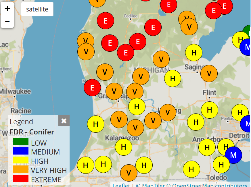
Current Fire Conditions
Drought is a deficiency in precipitation over an extended period. It is a part of normal climate variability in many climate zones. The duration of droughts varies widely. Drought can develop quickly and last only for a matter of weeks, exacerbated by extreme heat and/or wind, but more commonly drought can persist for months or years.
There have been at least three major U.S. droughts in the last 100 years. Two of these, the 1930s Dust Bowl drought and the 1950s drought, each lasted 5-7 seven years and covered large areas of the country with significant impacts. Although hurricanes and tornadoes are more dramatic, droughts are among the most costly weather-related events and the most far-reaching. From 1980–2020, there were 285 weather/climate disaster events with losses exceeding $1 billion (CPI-Adjusted) each to affect the United States.
Drought may require safety precautions just like other weather hazards. Dry conditions often lead to brush fires or wildfires. Local officials may ask that you not burn brush or trash during dry conditions and comply with other safety precautions. In extreme fire conditions, officials may issue mandatory evacuation orders to protect your life. Always follow these directives. They could save your life and the life of your family.
Types of Drought
Meteorological drought is based on the degree of dryness (rainfall deficit) and the length of the dry period.
Hydrologic drought is based on the impact of rainfall deficits on the water supply such as stream flow, reservoir and lake levels, and groundwater table decline.
Agricultural drought is based on the impacts to agriculture by factors such as rainfall deficits, soil water deficits, reduced groundwater, or reservoir levels needed for irrigation.
Socioeconomic drought is based on the impact of drought conditions (meteorological, agricultural, or hydrological drought) on the supply and demand of some economic goods. Socioeconomic drought occurs when the demand for an economic good exceeds the supply due to a weather-related deficit in the water supply.
U.S.A and Global Events for May 28th:
1880: An estimated F4 tornado hit Savoy, Texas. The storm killed 14 people, and 60 others were injured. It leveled the entire business and northeast residential sections. The tornado was described as “a funnel blazing with balls of fire.”
1973: An F3 tornado moved east and struck the northern portion of Athens, Georgia. Destruction was massive near Athens, with losses estimated at ten million dollars. Damage from the storm included 545 homes and 17 businesses. Hundreds of large trees more than 100 years old were destroyed.
2015: Some parts of Oklahoma have seen more than a foot of rain during May 2015. Storms killed at least 17 people in Texas and Oklahoma, and more than a dozen are still missing. State climatologist Gary McManus from the Oklahoma Climatological Survey calculated the May rainfall total averaged over all Sooner State reporting stations through midday May 29 – 14.18 inches – was easily outpacing the previous record wet month, set in October 1941 (10.75 inches).
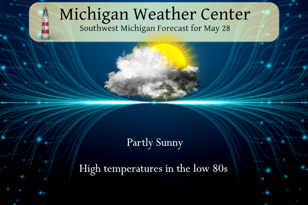
Grand Rapids Forecast
5 28 grrForecast Discussion
.SHORT TERM...(Today through Monday)
Issued at 244 AM EDT Sun May 28 2023

High pressure remains in control of our weather into Monday. Temps
at 925/850 mb are progged to climb slowly into Monday. Most
locations on Saturday saw high temperatures of 75 to 80 degrees.
Today many locations will end up in the upper 70`s to lower 80`s.
Then for Memorial Day, values will go up another degree or two.
These values are in line with the ensemble values from the models,
which don`t show much spread either. Overnight low temperatures
will also continue to moderate. Surface dewpoints are 3 to 6
degrees higher as compared to 24 hours ago. That will act to keep
up low temperatures to start the day today and for tonight.

As for the fog risk, that also looks low as crossover
temperatures are forecast to be low compared to the forecast
minimum temperatures tonight. The HRRR also shows no fog.

Bufkit overviews reveal a dry DGZ through Monday. Above the DGZ RH
values are relatively high, so we will likely see another day with
cirrus clouds around, however they are forecast to dissipate
Monday as the RH values decrease through the day. Satellite
imagery also shows a steady stream of clouds spreading into the
CWA from the southeast.


.LONG TERM...(Monday night through Saturday)
Issued at 244 AM EDT Sun May 28 2023

Early-season stretch of heat appears likely from Tuesday to Thursday
and possibly Friday as well. The Great Lakes will be under the high
pressure side of a Rex block with weak tropospheric flow. The high
is expected to gradually retrograde from just east of the Great
Lakes to west as the polar jet stream amplifies over Canada.
Dependent on how that evolves, a cluster of ensemble solutions
suggest a backdoor cold front may break the heat late in the week.

Except for within several miles of Lake Michigan where the diurnal
lake breeze will slowly advance against the prevailing gentle
southeasterly surface flow, high temperatures in the upper 80s to
lower 90s are favored. To understand how this fits climatologically
for the Grand Rapids, Lansing, Kalamazoo, and Battle Creek areas
(with roughly 130 years of daily wx obs), having a year which
recorded a high temperature of 90 degrees on or before June 5
occurred 14-27 percent of the time. And only 6-15 percent of years
recorded 3 or more days of 90 degree temperatures on or before June
5.

While this may constitute a heat wave colloquially if 3 days in a
row hit 90 degrees, one positive for human health this time around
is relatively low humidity levels and comfortable nighttime
temperatures which should keep accumulated heat stress more
manageable. On the other hand, the hot and dry pattern will
continue to increase the stress on agriculture and fire management.

One small quibble in this pattern is whether to even mention a
slight chance (20 percent) of diurnally driven isolated
showers/storms Wed and Thu or keep it closer to silent 10 percent.
Will lean toward the ensemble suites that are on the hotter and
drier side, which include the ECE and CMC. The GEFS ensemble
envelope has consistently been on the cooler and more moist side of
the other ensembles and the NBM, with highs in the lower-mid 80s and
afternoon dew points in the lower 60s, resulting in more CAPE,
clouds, and chance of precip. Those dew points are likely to be
unrealistically high.
Beautiful day out today!! I hope everybody is enjoying the Holiday weekend.
Into the 80s today! Incredible weather!
Eeeee Eeeee Blowtorch warning! May will be our 13th warm month in a row!
Heck of a warm streak we’ve been on!! Looking at 90’s this coming week too! Gonna be a scorcher!
Well…we received our beautiful Holiday weekend. Fly your flag(s), visit a Memorial Day Ceremony on Monday, enjoy the family, and always keep in mind, that Freedom/Liberty isn’t free.
^THIS^
And don’t shop at Target or buy Bud Light!
Amen!!!
The official H/L at Grand Rapids yesterday was 79/43. There was no rain fall and GR has only had 0.03” of rain fall in the past 19 days. There was 83% of possible sunshine yesterday. There were 0 Cooling Degree Days and 4 Heating Degree Days. So far this May there have been just 33 Cooling Degree Days that is a temperature of -29 And there have been 211 Heating Degree Days that is a departure of +2. So the bottom line is at this point May has had above average need for heating and less than average need for… Read more »
No doubt with cool pattern we have been in!
For today the average H/L is 74/53 the record high of 94 was set in 2008 the record low of 33 was set in 1894 and 1949. The record rain fall amount of 1.85” fell in 1935. At this time it is clear and 49 here in MBY.
Slim
The week ahead looks to really warm up with highs that could reach 90 or better. Now while this in much warmer than average the dew point look to mostly remain low so that it should not feel too bad outside and with the expected lows it would be a good idea to open the windows at night and close them during the day. While the expected temperatures could qualify for mini “heatwave” the NWS points out that with the low dew points and rather cool overnight temperatures it should not be too bad.
Slim
While we may not officially be in a drought it has became very dry in our area and will end May as one of the driest on record. That dry conditions will be noted as a bigger issue than it being either a cool or warm month.
Slim