We are now 2/3 of the way through Met fall and close out October with mainly wetter and warmer than normal conditions. Here in Otsego, we ended up with 5.84 inches of rainfall for the month and 8.00 inches for fall thus far.
Yesterday’s high was 54.5° and the low was 37.4°. We currently have 35° at 5:45.
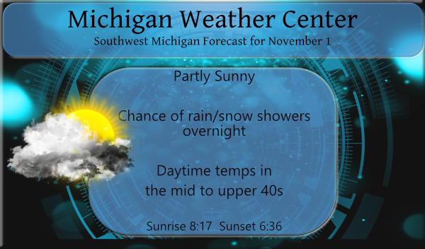
We are now in the transition period from fall to winter and the first snowflakes of the season may be seen overnight from lake effect though little or no accumulation is expected. Temps will be in the 40s this week with overnight lows in the upper 20s to low 30s.
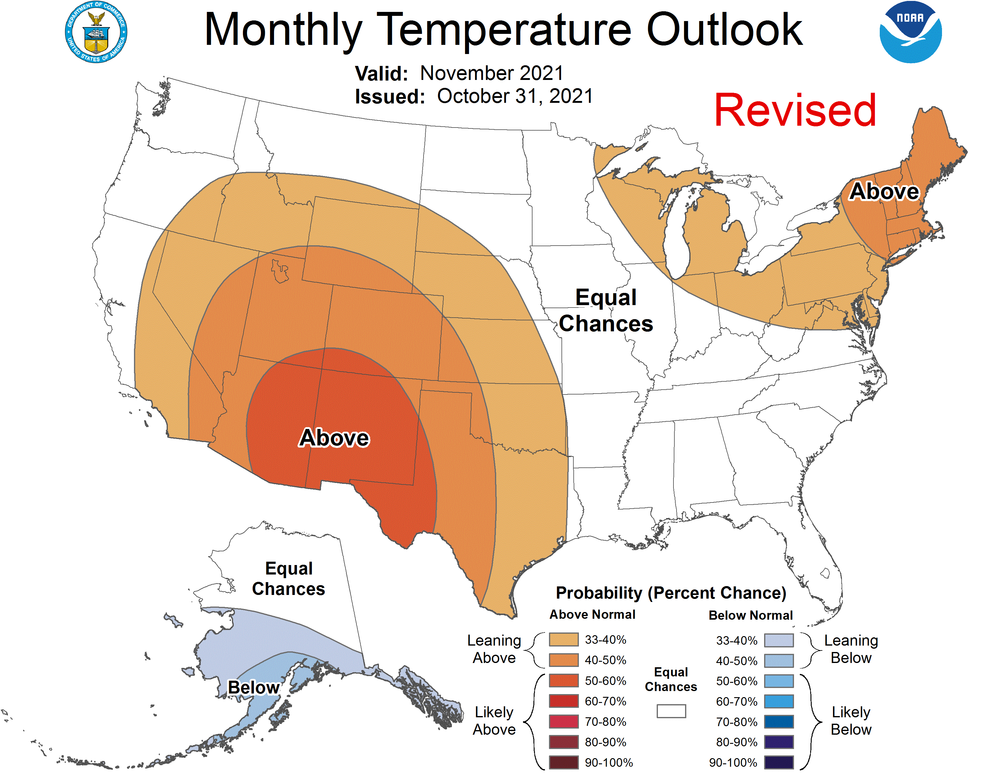
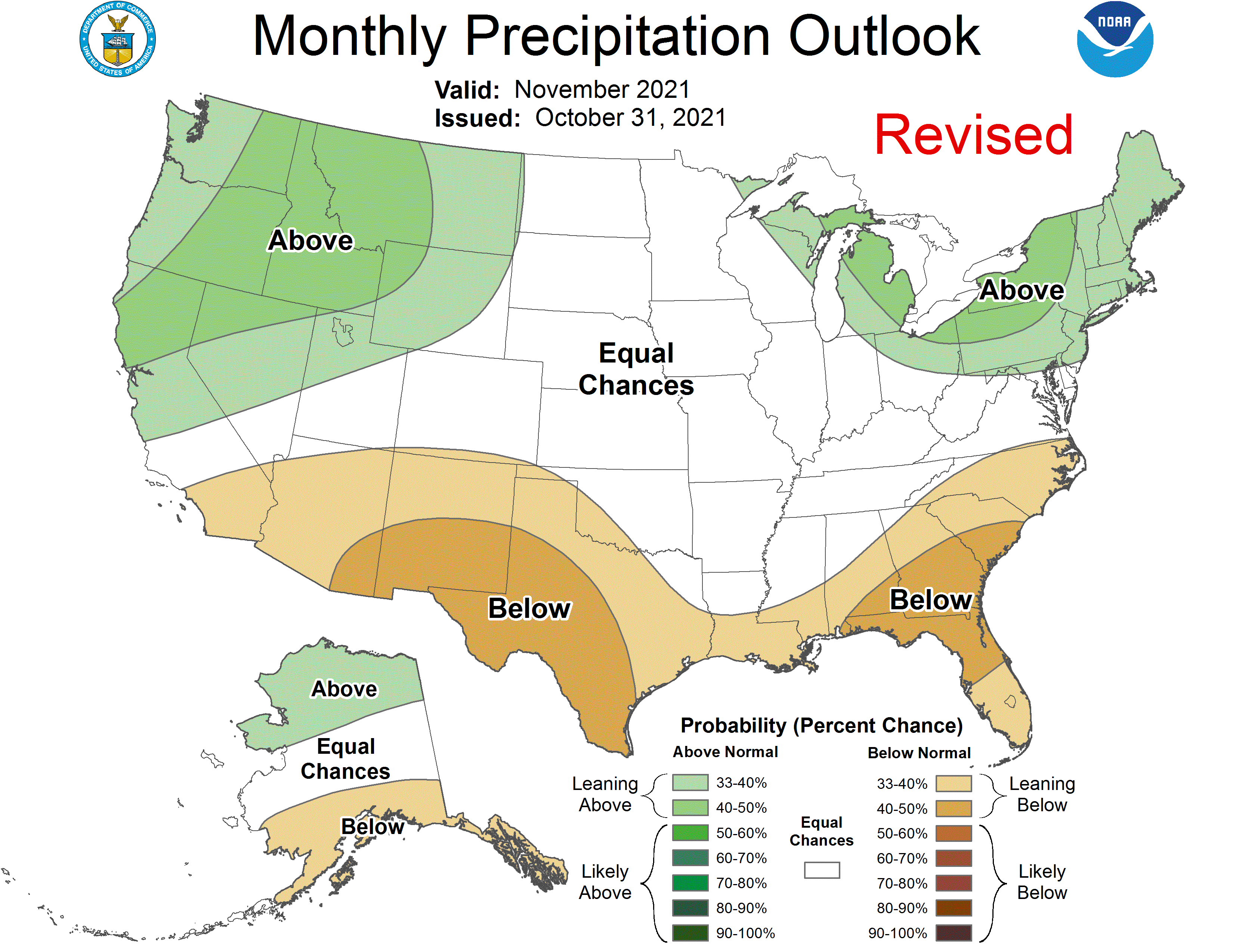
Looking at the CPC guesses we will have a mainly dry period through the next couple of weeks with normal to slightly above normal temps. Below is the revised guesses for November:
[columns] [span6]
[/span6][span6]
[/span6][/columns]
Forecast Discussion
-- Cool week with occasional lake effect showers --

An omega block in the North American pattern the next few days
will keep the Great Lakes region entrenched in the downstream
trough with cooler than normal air.

We will be on the poleward side of the cyclonicly curved upper
level jet Monday night through Thursday morning, and as occasional
shortwaves move through this flow pattern, the increasing depth
of instability will allow lake effect clouds to grow tall and cold
enough to produce precipitation. What is limiting the case for
more significant lake effect is fairly dry upstream air resulting
in higher cloud bases, plus inversion/equilibrium heights will
tend to be rather low at 6000 to 8000 feet above the surface,
often preventing cumulus from reaching far into the DGZ if at all.

So while the intensity of lake effect showers will be mostly
dependent on shortwaves, it`s not surprising to see different
solutions from various models on timing. But two or three rounds
of upticked shower activity between Monday night and Thursday
morning seem possible. Isolated heavier bursts of precip from
showers occurring at night could result in a changeover from rain
to snow, perhaps leaving a light coating of accumulation.

The omega block will break down in the latter part of the week,
deamplifying and translating east, giving us ridging/high pressure
and moderating temperatures after Thursday. Split flow in the
upper levels seems to be the most likely solution going into the
weekend, which would keep the chances of precipitation or other
interesting weather relatively low.
Lake effect snow advisorys out for northern Michigan and in the upper peninsula will we see any snow showers overnight?? Stay tuned from posting weather ahead and not looking back here comes Winter woo woo ..InDY
Rock n roll!
60 degrees and sunny next Monday per Wood? Don’t count out nice fall weather yet…
Yeah I was just looking at the outlooks for the next week or two and we are back in the red again. Day after day after day of above average temps with a few below average thrown in every couple weeks. Might as well keep them going through May. Who knew???
36* degrees out in my area love below average days lets keep them going through May!!! Who Knew ??? InDY …
Phew, what a warm October! Looks like many guesses are saying a mild November as well? Lots of sun this week too for areas outside of lake effect. Inside lake effect, get ready for 4 months of grey.
October was grey also 37% sunshine only so make that 5 months lol….Such a transition month bring on the cold and snow ….InDY …
Not too far from average. I thought we had plenty of nice sun in October. And warmth too.
While I am not a big fan of Joe Bastardi there is a brief preview of his so called winter guess. For our area his claim is for the winter slightly below average temperatures and according to him 125% of our snow fall. The break down is near to slightly below average temps in November and January. He has December as being much below average in temperatures and he has no mention on February. Put this down and if this does not play out to his guess well lets just say even a no working analog clock is right 2… Read more »
The overnight low here at my house was 31 and there is frost here and there is ice in the bird bath water. I am sure it has happened before but most of the leaves are still on the trees here and while there is now some color there are still a lot of green leaves on the trees. A shower yesterday dropped 0.04″ of rain here. At this time it is clear and 32 here. Oh BTY official low at GRR looks to have been a warmer 36.
Slim
October 2021 is now in the record books. It was a warm and wet month to day the least. At Grand Rapids with a mean of 57.0 it was the 7th warmest on record the high for the month was 80 on the 11th there were a total of 12 days with highs of 70 or better. The low for the month was 31 on the 24 and 27th. At Muskegon with a mean of 58.2 it was the 3rd warmest October the high for the month there was 79 on the 11th there were a total of 12 days… Read more »
Only 8 days in October that was rain free and some thought it wss a dry month come onnn could you imagine if that was all.snow great spotty….Welcome to November!!! Lets get this Winter party started….InDY
What? Snow is in the forecast! Who would have thought? You mean we won’t see above normal temps all winter like some are suggesting! Bring on the cold and snow and get this rock n roll party started! Bring it! PS:the Lions are the worst team ever!