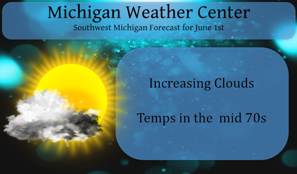
After a dry and cool spring, especially towards the end, we look towards our first steps into summer. One would think we would flip over into a wetter pattern after our lack of significant snow and rain over the past two seasons but who knows as the crystal ball remains cloudy as do the long-range outlooks which have been overproducing on precipitation guesses.
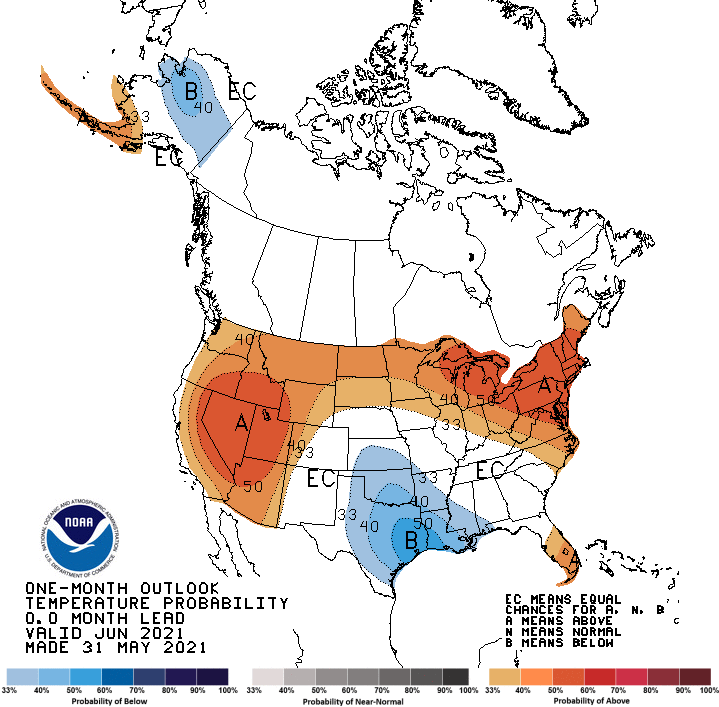
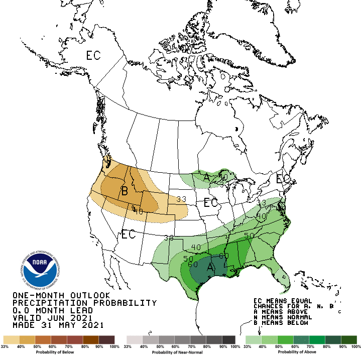
The updated guess for June came out yesterday which gives us a 40 to 50% chance of above-normal temps and an equal chance of above/below normal rainfall.
[columns] [span6]
[/span6][span6]
[/span6][/columns]
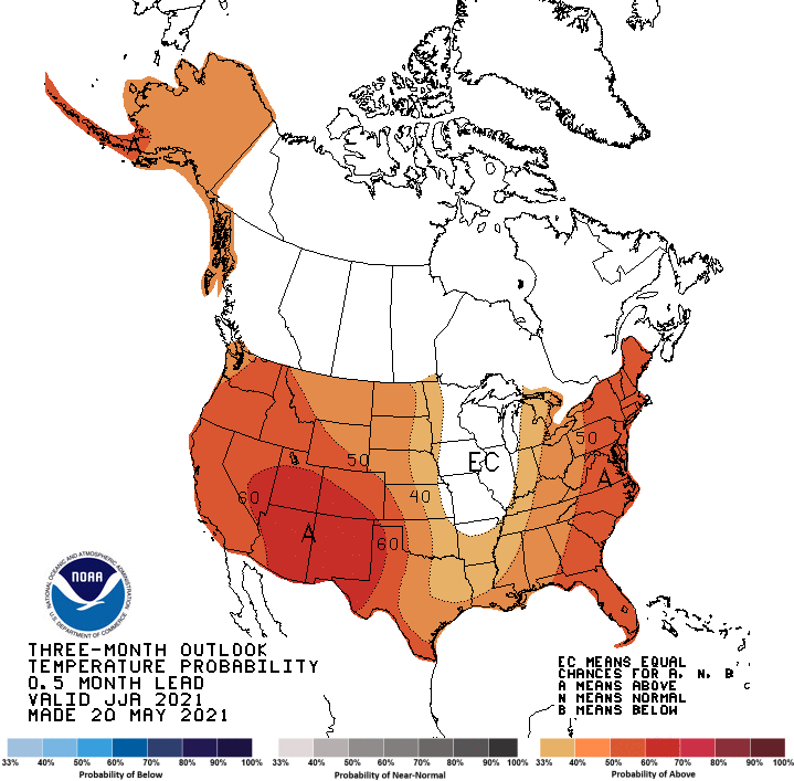
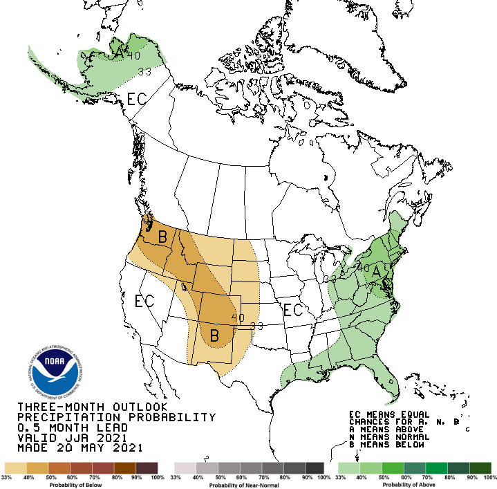
Looking at the long-range summer outlook the CPC is guessing chances of above-normal temps and an equal chance of above or below normal rainfall.
[columns] [span6]
[/span6][span6]
[/span6][/columns]
There is a formula that is used to ‘predict’ long-range forecasts which are plugged into a computer and guesses are made as to what may or may not happen. This is called the Heidke Skill Score.
The Heidke Skill Score (HSS) compares how often the forecast category correctly matches the observed category, over and above the number of correct “hits” expected by chance alone. Looking at the trends for the past few month I have found up to 5% of data points used for the final outcome of the guesses are missing so all long-range forecasts are guesses at best
This score utilizes the number of correct and incorrect category hits. The values range from -50 to 100. A score of 100 indicates a perfect forecast and a score of -50 indicates a perfectly incorrect forecast. Scores greater than 0 indicate improvement compared to a random forecast and indicate skill.
For monthly and seasonal forecasts, the equal chances (EC) forecast category are included in scores.
The equation for the score is:
HSS (%) = 100 * (H - E) / (T - E)
where H = Number of correct forecasts, E = Expected number of correct forecasts (1/3 of total), and T = Total number of valid forecast-observation pairs.
The equation for the score including EC forecasts is:
HSSwithEC (%) = HSS * coverage
where coverage = number of non EC forecasts/Total.
It is my humble opinion that the further out we try to predict the weather the more error is thrown into it and all it does is create excitement over the pretty outlook maps for those into warmer or cooler temps. 🙄
Forecast Discussion
- Risk for scattered thunderstorms Wed aftn through Thu

A mid level trough pulls in from the west and east of the region
Wednesday afternoon into Thursday. At the same time PWAT values
increase to around 1.3 inches with forecast soundings showing some
instability. The soundings are relatively moist as well.  Models
are generally in good agreement on that scenario. Given the
moisture....lift and weak instability...we will continue to
feature the potential for a few storms. Deep layer is shown to be
relatively weak so organized convection looks unlikely. We are
seeing mainly diurnal instability through the weekend but no
forcing mechanisms at this time so for now we will feature a
mainly dry weekend.

- Above normal temperatures over the weekend into early next week

With the passage of the mid level trough Thursday...heights rise
steadily through the weekend. Deep and steady warm air advection
occurs here in MI. The 850 mb thermal ridge arrives as well with
values in the teens. If we mix to that level...temps will be well
into the 80s...maybe even a few 90 degree readings.

- It could turn active next week

While there is considerable spread in the models for the early to
middle part of next week...a general idea of a colder airmass
dropping southward through the Canadian Prairies meeting up with
Gulf moisture in the Upper Plains exists. That frontal zone and
associated strengthening winds could become the source of some
stronger storms.
I see May ended up with below normal temps! How is that possible? Another below normal temp month! This despite constant warm weather hype! Absolutely incredible!
Whew!!! Gonna be a scorcher later in the week!! Get your pools and sprinklers ready!!
Another heat wave? This blog is getting awfully quiet…
Just like another above average month May right?? Well it is meteorological summer now our cool Spring has passed on have a nice night..INDY
Hope everyone enjoyed the cooler weather, because the heat is coming back with a vengeance!!! Prepare now and make sure that A/C is ready to go!
https://weather.com/weather/tenday/l/b4ea0280869baa46799dc75eacef8904785ec43ad2f6fb098355fbc208a55e2c
I had not heard of the HSS. Thanks for the education.
Looks like most of the US will be feeling the heat over the next 7-10 days. Triple digit temps up and down California this past weekend, including some all time May high records.
Welcome meteorological summer. Well it is now June and we are now at the start of the summer season. This past May was one of many ups and downs. The mean for the month at Grand Rapids was 57.5 a departure of -1.7. The high of 86 was reached on 4 days and the low for the month was 30 on the 1st There were 7 days with highs of 80 or better and 6 nights with lows in the 60’s but there were 13 nights that got down into the 30’s with frost as late as the morning of… Read more »