With the shorter days and promise of cooler more tolerable temperatures we welcome the first day of meteorological fall. Sunrise today is 7:08 am, sunset is 8:16 pm. By the end of the month, sunrise/sunset times are 7:39/7:37 respectively. Daily high temperatures for September decrease by 11°F, from 77°F to 66°F, rarely falling below 55°F or exceeding 86°F. Daily low temperatures decrease by 10°F, from 59°F to 48°F, rarely falling below 37°F or exceeding 69°F. These stats are for SW Michigan.
Yesterday’s high temp was a pleasant 80° and our overnight low was 58° to close out August.
Weather History for SW Michigan
August 29
1863: A hard freeze ends the growing season at many interior locations. Lansing falls to 26 degrees, the coldest ever recorded in August there.
1982: Cool air from Canada continues pouring in, with a record low of 38 degrees at Muskegon and 41 degrees at Grand Rapids.
August 30
1949: A weak tornado struck just north of Grant in Newaygo County, causing some minor damage to small buildings and crops.
1976: Grand Rapids falls to 39 degrees, the coldest ever recorded during the month of August. Scattered frost occurs in rural areas.
1984: A tornado struck about 5 miles northeast of St. Johns in Clinton County, damaging two homes, but causing no injuries.
August 31
1993: Flash flooding hits Norton Shores in Muskegon County as slow moving thunderstorms dropped about an inch and a half of rain. Elsewhere, three people were struck by lightning in Otsego in Kalamazoo County. One suffered cardiac arrest but was not killed. The other two were treated for minor burns. The lightning strike occurred while two stranded motorists were huddled under an umbrella, watching the wrecker operator connect their vehicle. The lightning struck the umbrella and the motorists, then struck the wrecker operator, jolting him to the ground.
1953: August ends with a late season heat wave that will continue into September. Record highs of 97 are set at Grand Rapids, 96 at Lansing and 91 at Muskegon.
1975: Heavy rains on the last day of the month ensure that this will be the wettest August on record at Lansing and Muskegon. One to three inches of rain falls across the region, boosting the monthly total close to 10 inches.
2009: August ends on a cool note with a record low of 41 degrees at Muskegon. Some other readings include 34 at Big Rapids, 32 at Cadillac and 28 at Leota, in Clare County.
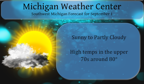
September 1
1953: A heat wave that began in late August continued into September, with record highs of 97 degrees at Grand Rapids and 96 at Lansing. The 95 degrees at Muskegon tied the record high for the month there.
2009: September begins with temperatures more typical of October. Lows include 41 degrees at Muskegon, 36 at Ludington, Hersey and Baldwin, and 35 at Harrison. Cadillac fell to 32 degrees for the second morning in a row, and Leota in Clare County fell to 30 degrees.
2018: Four tornadoes occurred within a two hour period during the evening. The first was a brief tornado that snapped trees near Gull Lake in Barry County. This was followed by a tornado with winds estimated at 100 mph that destroyed a manufactured home at Morley in Mecosta County. Two other tornadoes took down trees, some of which fell on houses, in Jackson and Clinton Counties.
September 2
1894: Lansing hits 99 degrees, setting their record high for the month of September.
1913: Grand Rapids hits 98 degrees tying their record high for the month of September.
September 3
1946: There was an early taste of autumn as Grand Rapids falls to 32 degrees for their earliest freeze on record.
September 4
1965: A tornado struck east of Grand Haven, destroying a barn, silo and factory. Debris was carried over two miles.
2008: The remnants of Hurricane Gustav brought heavy rains to southern Lower Michigan. Muskegon sets a daily rainfall record of 3.25 inches and Grand Rapids sets a record with 2.82 inches.
Weather History for SE Michigan
August 29
On August 29, 2008, 0.10 inches of rain fell on Detroit, one of only six days during the month that had light rainfall. That pushed the monthly total up to 0.27 inches making August 2008 the third driest August on record.
Also on August 29, 1982, Detroit, Flint, and Saginaw set new record lows for the month of August. The temperature fell to a chilly 37 degrees in Flint and Saginaw and 38 degrees in Detroit.
Also on this day on 1979, one F0 and three F1 tornadoes were sighted over Monroe county between 6:45pm and 7pm.
August 30
On August 30, 1984, an F2 tornado moved through Wayne County at 4:40am. It caused $4 million worth in property damage and caused 4 injuries.
August 31
On August 31, 2010, Detroit and Flint closed out August with three consecutive 90+ degree days with no rainfall. This marked the end of a very hot and dry August. When combining the two, it was the hottest and driest August combination on record for Southeast Michigan. Detroit had its sixth warmest and sixth driest August. Flint recorded its fifth warmest and driest August.
On August 31, 1980, there were peak wind gusts of 69 mph.
Also on August 31, 1894, marked the end of the driest summer month ever recorded in Detroit, with only 0.16 inches of rain falling throughout the entire month.
September 1
On September 1, 1967, Detroit experienced a record low of 42 degrees.
September 2
On September 2, 1984, an F3 tornado moved through Sanilac County at 5:40PM. This tornado caused one injury and over $500,000 in damage. This was the strongest tornado to ever hit Sanilac County and also caused the only injury ever reported in Sanilac County.
September 3
On September 3, 2011 in the late afternoon and evening, several thunderstorms fired up ahead of a cold front that was draped across lower Michigan. Ahead of the cold front temperatures soared into the 90s with heat indices near 100 degrees. The areas hardest hit with strong winds and hail were along I-94 from Ann Arbor to downtown Detroit including River Rouge where festival tents were blown down injuring about 10 people and at the University of Michigan where the football game was ended early due to the thunderstorms. Another hard hit area was from Huntington Woods to Madison Heights where winds were estimated up to 75 mph with numerous downed trees. About 100,000 DTE customers lost power due to the storms.
Also on September 3, 1953, the temperature rose to 100 degrees in Detroit, which is the record high for the day. This also marks the sixth day in a row (August 29-September 3) of record daily high temperatures!
September 4
On September 4, 1973, the Detroit daytime temperature rose to 92 degrees, which is the record high temperature for the day. The very next year, in 1974, the overnight temperature dropped to 40 degrees, which is the record low temperature for this day!
Forecast Discussion
- Dry into Friday

Dry weather is forecast into Friday with high pressure traversing
the area. BUFKIT overviews show a dry profile through Friday
night, so we are thinking we will remain dry through that time.
ECMWF ensembles show some light precipitation possible Friday
afternoon and Friday night, but this seems unreasonable given the
dry air.

- Rain chances increase this weekend

Rain shower chances increase this weekend as a cold front is
poised to move through in the Saturday and Saturday night time
frame. Aloft, an upper trough will be making inroads into the
Great Lakes with embedded shortwaves. Instability is not great
this weekend, so thinking the thunder threat is very minimal. Best
chance for storms would likely be over one of the Great Lakes
given the heat source they will provide. Bottom line the weekend
should contain a fair amount of cloud cover with solid chances for
some rain showers.

- Showery weather will likely continue into early next week

Showery weather will continue into early next week most likely as
the upper trough holds in place over the Great Lakes. Embedded
upper shortwaves will be rotating through the region early to mid
next week. Cannot rule of the chance for some storms as well given
the steep low level lapse rates that will be in place.

- Temperatures much closer to normals for the next 7 days

High and low temperatures will be much closer to normal over the
next 7 days as compared to where they have been in the recent
past. Highs will top out in the 70s most days and this is right
where normals are at. Same goes for low temperatures which will
largely be in the 50s.
Currently in my area 830pm and it’s dark temps in the low 70’s FALL! INDY
Decent chance for the Northern Lights tonight if the skies can stay clear. Double CME impact expected to hit any time now.
https://spaceweather.com/
Sweet! Thanks for the heads up.
Welcome to FALL ….Temps in the 70’s and lows in the 50’s we will take it!! No more heat in Sight ….INDY
Bring it on and this puts one month closer to the best season in MI! Winter rocks!
It is now all but official that August 2021 was the 9th warmest on record at Grand Rapids and Holland. The 4th warmest at Muskegon and at Lansing it ended up tied with 1955 for the warmest August on record there.
Slim
It was one of the hottest and humid August in recent memory. Don’t need to see that again anytime soon.
9th warmest? With all the warm weather hype you would have thought this was hottest summer ever? Incredible!
I don’t think you read his stats right. Lansing tied their hottest ever, 4th hottest ever at Muskegon, and inside the top 10 for Holland and Gr. That spans a lot of years, so yes, it was a notably hot month.
I understood exactly what he said! 9th warmest for GR and a bunch of warm weather hype from the warm weather fanatics! Outrageous!
So now Slim is a warm weather fanatic because he posts facts and stats about it being well above average? You have lost it.