Yesterday we had a high of 79.5° and the low was 61.5°. We don’t see any temps near 80 or the 70s for that matter in the near future, we may even see our first frost tonight as temps fall into the mid-30s.

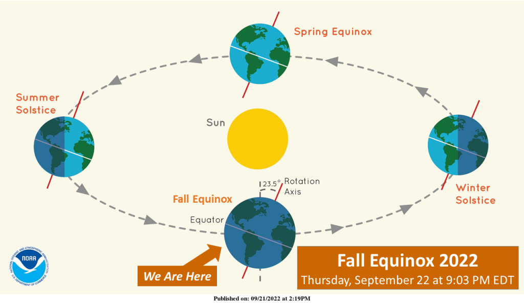
Thanks for the visit, sun! On Thursday, the spot on Earth at which the sun is directly overhead will cross the equator into the Southern Hemisphere, marking the fall (autumnal) equinox here in the Northern Hemisphere. This spot will continue southward until December 21 (the winter solstice), when its southernmost position will be attained. The sun will remain “above” the Southern Hemisphere until March 20 (the spring equinox), when this spot will again cross the equator, but northward into “our” hemisphere. Here in the Northern Hemisphere, periods of daylight have become steadily shorter since June 21 (the previous summer solstice). Thursday then begins six months during which the daily periods of darkness will exceed those of daylight.
Forecast Discussion
-- Chance of Rain Today --

Strong winds across Lake Michigan will spur the formation of
convection that will bring rain to the lakeshore with a chance of
thunder.

The mid level winds remain out of the north to northwest
with little directional wind shear at or below 850 mb. This will
allow winds to mix down to the surface, bringing gusty winds
across lower Michigan. The soundings tell the story with LWA, MKG
and BIV model soundings showing LCL`s around 2 to 3KFT. The
moisture is all at or below 5kft with dry air aloft. So given the
moisture and any fetch across the lake, there should be enough
instability with low level shear to allow for showers. QPF is
fairly limited so rainfall amounts will not be significant.

-- Patchy frost possible Thursday night into Friday morning --

High pressure will continue to build into the midwest and over the
Great Lakes region Thursday into Friday. This ridge will bring
cooler and drier air into the region. The dry air aloft will keep
skies clear, with the high pressure allowing for winds to be calm.
The other indicator is that the dewpoints will drop below 35
degrees. So with dewpoints just above freezing, little to no wind,
and clear skies, this is a good recipe for frost. Any lingering
clouds and/or wind could preclude and interrupt frost
formation. However, given current expected conditions, frost
headlines should be needed.

-- Showers this weekend into early next week --

An upper level trough will drop down into the Great lakes with the
mid to long range models in fair agreement on position and timing
of this feature. mid level moisture should couple with a
positively tilted trough to bring an upper level jet streak
through southern Michigan Saturday. This will allow for upper
level divergence along with wind shear across Lake Michigan which
indicates good probabilities for showers and storms Saturday
night into Sunday. Northerly flow behind the trough should further
spark showers and a chance of storms Sunday into early Monday.
The upper level system should then trek eastward.

Lows in the 40’s should really pop some beautiful colors outside check them out this weekend as msny trees have already started the turn FALL!! INDY
How about lows in 30’s tonight! Incredible cold!
Im thinking the old furnace will be kicking on overnight… Feels Great outside FALl..INDY
You know it! Bring on winter!
Frost and freeze watches out to our north.. Here we go love it …. INDY
58 out in my hood wow welcome to Fall is right.. When did Summer go?? INDY
Keep these below normal temps rocking! I love it!
Wow, very cold and windy today! Feels like late Fall already! Incredible cold!
Wow CPC turns the warmth back on for week 2-4.
I’m back in Michigan finally. The temps the next week look really comfortable for this time of year… hopefully there is not too much rain, Art Prize is going on currently
Also happy first day of Autumn!
Also it was nice driving back from Ohio. A lot of small towns along the way with a nice simple lifestyle
There are lots of very rural areas especially in northwest Ohio. I drove all side streets in ohio back from Columbus once and I was in towns I never heard of. Your right simple lifestyle but I could never imagine living a half hour or more from things to do (stores, food etc) but that’s just me.
57 degrees here this morning in Chicago – some 20 degrees cooler than 24 hours ago. Dew point is in the low 40s.
The official H/L at Grand Rapids yesterday was 81/61 there was no rain fall reported at GRR and 56% of possible sunshine. Yesterday looks to be the last warm for a week or more. The overnight low so far at GRR has been 52 here in MBY it has just fallen to 51 with clear skies. There are some nice lake effect rain bands setting up in the Traverse City area and in central UP. For today the average H/L remains 72/51 the record high of 95 was set in 2017 and the record low of 33 was set in… Read more »
I remember being at the beach and doing some swimming around September 25th. 2017. It was a hot one.
Yesterday I could the line of thunderstorms build just to my northeast That was a good show to see as the clouds just built up and up and became dark. There was hail and heavy rain just to my north and east. Here in MBY I only received 0.01” of rain fall but it was enough to get the driveway wet.
Slim
Some of the first lake effect rain bands of the season this morning. Most pronounced currently across the Northern Lower with some nice banding.
Tonight looks cold. The forecast overnight low at my house is 36.