Allegan County was left high and dry once again yesterday. We had a high temp of 87° with a 72° dewpoint and a low of 64°. Today we will have a more comfortable airmass in place with mostly sunny skies and highs in the mid-70s.
Sunrise today is 7:23 and sunset is 7:52 pm.
Weather History for SW Michigan
September 12
1986: From 6 to 12 inches of rain in three days resulted in record flooding from Muskegon to Saginaw. The flooding was worsened by the collapse of several dams. Ten people were killed and damage estimates approached half a billion dollars.
September 13
1939: A record-breaking heatwave begins with the temperature hitting 95 degrees at Grand Rapids.
1952: Muskegon reaches 92 degrees for their third record high temperature in a row.
1962: A severe thunderstorm struck Lansing with wind gusts over 65 mph, producing light damage across the city.
2008: Five tornadoes strike southern Lower Michigan. Four of the tornadoes were spawned by one thunderstorm. A car dealership and a restaurant were damaged in Paw Paw and weak tornadoes damaged trees near Mattawan in Allegan County, Millers Corner in Kalamazoo County, and Brookfield in Eaton County. Several buildings had roof damage from a tornado that struck Plymouth in Wayne County.
September 14
1928: Tornadoes struck across Lower Michigan. A tornado hit in Mason County south of Scottville damaging at least three homes and injuring two people. The roof of one home was carried over a mile. Another tornado destroyed several barns, killing cattle about 2 miles south of Cedar Springs in Kent County. What may have been a tornado took part of the roof off a factory and warehouse in Grand Rapids.
2008: Ten days after the remnants of Hurricane Gustav drenched southern Lower Michigan, the remnants of Hurricane Ike brought another round of heavy rain. From 3 to 6 inches of rain caused flooding, with some road washouts.
September 15
1939: A four-day heatwave peaks across western Michigan with Grand Rapids hitting 97 degrees and Lansing 94 degrees.
September 16
1886: A swarm of tornadoes hits southern Lower Michigan from late morning into the early afternoon. At least ten separate tornadoes struck, causing damage in Cass, Livingston, Kalamazoo, Eaton, and Clinton Counties. One person was killed and another injured in a tornado that hit Brighton.
1899: Grand Rapids records a high of 98 degrees, setting the record for its hottest September temperature, which would be tied on September 2, 1913.
September 17
1972: A severe thunderstorm produces two tornadoes. The first damages a car six miles northeast of Kalamazoo. The second damages a house three miles south of Middleville.
1973: It was a record cool day as clouds and rain held high temperatures in the 40s across western Michigan. The high of 47 degrees this afternoon at Grand Rapids would be followed by a record low of 35 degrees the next morning.
1977: Two tornadoes struck Lower Michigan. One person was injured in the town of Flushing in Genesee County. Thirty homes and a library sustained heavy damage there. Another tornado hit near Westphalia in Clinton County, damaging a house and a garage.
September 18
1918: A tornado destroyed a large barn about 5 miles southeast of Grand Haven in Ottawa County, and carried the timbers a half-mile.
Weather History for SE Michigan
September 12
On September 12, 1986, a 3 day period of persistent rainfall that caused the worst flooding in 50 years finally ended, which resulted in damage between 400 and 500 million dollars!
September 13
On September 13, 2019, severe storms tracked across the Metro Detroit and Thumb regions. Hail up to golf ball-sized was observed in southwest Oakland County while a wind gust to 72 mph was measured over the Detroit River.
On September 13, 2008, tropical rains started to fall over Southeast Lower Michigan. In about 48 hours from the evening of September 12 to the evening of September 14, 3 to 6 inches of rain fell. The rain was in part due to a slow-moving cold front that crossed Lower Michigan associated with moisture from a Pacific tropical storm and the remnants directly from Hurricane Ike that struck the Texas coast on September 12.
Also on September 13, 1962, in Wayne county, there were wind gusts of 73 mph along with a thunderstorm.
September 14
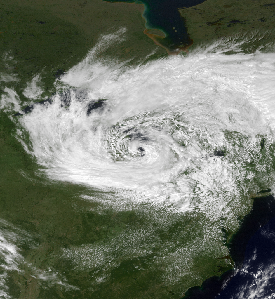
On September 14, 1996, a pressure of 993 MB was recorded in the “eye” of an intense storm system that formed over Lake Huron that had many uncanny similarities to a tropical hurricane. In fact, this storm was nicknamed the “Huroncane”. By 2 PM on this day, the “eye” of this storm measured 20 miles across and was ringed by tall cumulus clouds resembling an eyewall of a normal hurricane. At one point, this storm even produced tropical storm-force winds (39-73mph)!
September 15
On September 15, 1939, the temperature rose to a record 100 degrees in Detroit for the day. This was the highest temperature record for the whole month of September.
September 16
On September 16, 1955, Flint experienced a record high of 90 degrees. This marked the beginning of a 3-day record high streak in Flint, with the 17th and the 18th experiencing temperatures of 94 and 93 degrees respectively.
September 17
On September 17, 1974, an F2 tornado hit Genesee County at 11:05 pm. This tornado cost $25,000 in damages.
September 18
On September 18, 1977, the tornado sirens beat the alarm clocks when an F1 tornado hit St. Clair County at a VERY EARLY 2:25 AM.
Forecast Discussion
-- Dry Weather Through Thursday --

The line of showers and storms created by the frontal pattern
continues to move eastward. Cooler, drier air will filter into the
region today. However, cooler is only relative as maximum
temperatures will remain above normal.
 High pressure will build over the region allowing for fair/mild
weather to persist through most of Friday.

-- Next Chance of showers/storms Friday into Saturday --

An upper level trough moving through Canada will have an
associated frontal system that will extend from NE Canada into
the Midwest. This will be the next chance for precipitation. There
are some timing concerns as the air will be fairly dry so any
precip will have to moisten the atmosphere as it approaches.
Given the latest soundings, this system will enter a moisture
starved atmosphere with little in the way of thickness cooling
occuring. The best opportunity for rain will be early Saturday
morning when diurnal cooling along with dynamic lift could allow
for light rain Saturday morning, mainly along the US 10 corridor.

-- Warmer Then Normal Temperatures ahead --

The biggest trend over the next week is the upward trend in
temperatures across the region. Southwest Michigan was warmer then
normal today and that will continue into next week. While the
approaching front will stall the warming temperatures, the +1 to
+2 sigma signal from standardized anomalies shows an upward trend
in the mean temperature. Given this,CPC`s 6 to 10 day and 8 to 14
day outlooks have above average temperatures trending. Summertime
temperatures in the mid to upper 80s are expected through the
weekend and into early next week.


Phew, we had 90’s in Michigan again yesterday!
We also had highs just in the low 60’s and lows as cool as 40 in Michigan yesterday!
Slim
Well outside West Michigan however
It was hot out yesterday
The overnight low both here and officially at GRR was 57. Here at my house there was no rain yesterday. With the clouds and the wind most of yesterday was rather comfortable. I cut the grass and it was not bad out at all and by the time I went for my walk at 7 PM there were some people with light jackets on as the wind did feel cool by that time. At this time it is sunny and 63 here. I had to take a quick trip up to Bay City on Monday I managed to miss most… Read more »
over here it rained for 5 min and then it was over
It’s been a warm start to September and only getting warmer. Looks to be the warmest start to the month since 2016.
Get colder!
i got a little bit and at one time yesterday i had 3 flashes of lighting and then thunder, don’t know what was up with that
Not sure how much rain we received yesterday, but it was a bunch. There is standing water out back behind our house.
It looks to have been spotty as officially Lansing only recorded 0.08″
Slim