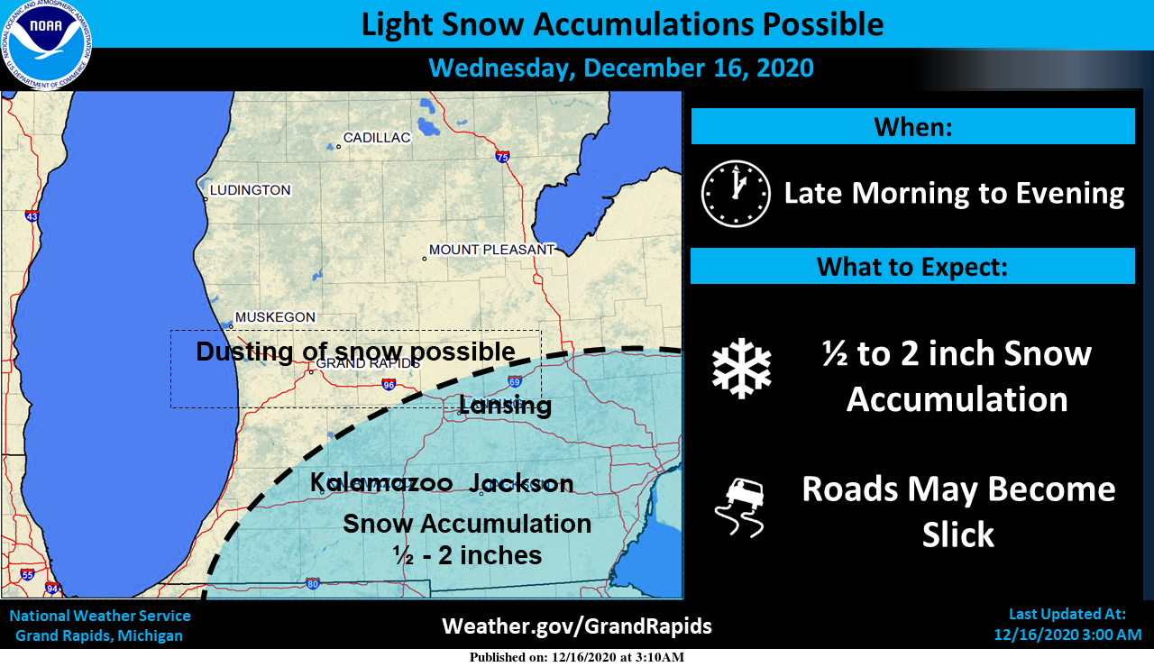
Snow is likely south and east of Grand Rapids today though accumulations will be meager at best in the half-inch range for most of the area. This will be from the edge of a major winter storm system that will pass through the Virginias up into southern New England where up to two feet of snow may fall.
Weather History
December 13
1920: Mild weather prevails across Lower Michigan with record highs in the upper 50s.
1973: A snowstorm drops about 8 inches of snow from Grand Rapids to Lansing.
December 14
1907: A snowstorm moves across Lower Michigan, dropping from 5 to 8 inches of snow.
1975: Record warmth continues for the second day across Lower Michigan. Morning lows in the upper 40s are followed by high temperatures near 60 degrees.
December 15
1971: For the second time in 5 days, record high temperatures are followed by record rains. The temperature hits 60 at Grand Rapids and 64 degrees at Lansing followed by about 2 inches of rain.
1987: A winter storm drops from 8 to 12 inches of snow from Grand Haven to Ludington. Muskegon sets a daily snowfall record of 12.1 inches of snow.
December 16
1984: Mild weather prevails with record highs of 61 degrees at Lansing and Grand Rapids.
1989: Persistent cold weather continues during the coldest Decembers on record in Lower Michigan. A record low of 2 below zero is recorded at Grand Rapids while another 5 inches of snow piles up at Muskegon, contributing to a monthly total of 77 inches there.
December 17
1963: Lake effect snow buries Muskegon with a three day total of 34 inches of snow from the 16th to the 18th. This will be the snowiest December in Muskegon history with a grand total of 82.6 inches for the month.
December 18
1884: Temperatures plunge well below zero during a three-day cold wave. Lansing records an all-time December low of 25 below zero.
1939: Mild weather continues for the second consecutive day with highs in the 50s and overnight lows remaining above freezing
December 19
1929: Cold and snowy weather prevails with high temperatures only around 10 degrees and heavy lake effect snow. Ten inches of snow falls at Grand Rapids on this date, with a three day total of almost 20 inches from the 18th to the 20th.
1983: A massive area of arctic high pressure dominates the weather across much of North America during an historic cold wave. Grand Rapids falls to 18 degrees below zero, setting their all-time December record low.
2008: A record 10.2 inches of snow fell at Grand Rapids during one of the snowiest months on record in southwest Lower Michigan. Some of the impressive monthly snow totals are: 88.7 inches at Hart in Oceana County, 68.6 inches at Muskegon and 54.6 inches at Grand Rapids. 2008 is also the snowiest calendar year on record at Hart, with over 200 inches and at Grand Rapids with 140.7 inches for the year.
I sure hope Christmas is cold and snowy like some of the models are showing. Of all days to have snow, Christmas is the best one!
We are still 9 days away… I’ll keep my hopes low for now to be safe.
Bill steffens the Chief just said coldest air of the season for Christmas day with lake effect snow showers we will take it ……INDY
Here is the EURO snow map through Christmas morning! Can you say White Christmas!
https://weather.us/model-charts/euro/usa/snow-depth-in/20201225-1200z.html
Wow better then last year’s 60’s that’s for sure ….Keep it coming . .INDY
Looking good for a more wintery pattern coming starting around this Saturday for my area we will take it we got some snow deficits to start making up with a warm lake Michigan and a cold front that will be no probs stay tuned….Bring on a white Christmas woo wooo INDY
Huh? Wood has low to mid 40’s multiple days next week LOL If anything, that’s the start of yet another warm up.
Yet another major Winter storm goes around us, this time to the SE. Seems to be the continuing pattern left from last Winter. By the weekend we will be 20 inches below normal for snow, and by Christmas we could be over 2 feet below normal! Slim, I know you posted it recently but I can’t find it, what is the date for the latest 1 whole inch of snow?
The latest date for a seasonal total of 1″ at Grand Rapids was in the winter of 1998/99 when Grand Rapids did not reach 1″ for that season until December 21st. But note that January that year Grand Rapids had 46.8″ of snow fall most of that fell between January 2nd and the 12th
Slim
I wouldn’t mind that at all. A condensed Winter for about 2 weeks then back to nothing. Thanks!
Christmas day forcast High of 23*: degrees with snow showers yes long ways out but the models are jumping on it that would be way better then last year’s 60’s as of the slow start to Winter this year we definitely will take it ..Bring on a white Christmas …INDY
Sounds incredible! Bring it!