This is another article on weather extremes from NOAA Center for Environmental Information which gives us a peek into the future climate for the state.
Figure 1

Michigan has a humid climate with large seasonal changes in temperature. Summers are warm and humid while winters are cold. The Great Lakes play an important role in the state’s climate. The Lower Peninsula is bordered by Lake Michigan to the west and by Lakes Huron and Erie to the east. The Upper Peninsula is bordered by Lake Superior to the north and Lakes Michigan and Huron to the east and south. The lakes moderate the climate, causing Michigan to be more temperate and moist compared to other north-central states. The moderating effect is most evident along the shores, which are considerably warmer during the winter and cooler in the summer compared to more inland locations. For example, Lansing and Muskegon have similar latitudes, but experience very different frequencies of hot and cold days. Lansing, which is located in the center of the state, averages 6.6 days with maximum temperatures above 90°F and 9 days with minimum temperatures below 0°F. In contrast, Muskegon, which is located along the western shore of Lake Michigan, averages only 1.8 days above 90°F and 2.7 days below 0°F each year. The moderating effects are even more striking along the shores of the even colder waters of Lake Superior in the Upper Peninsula. Sault St Marie averages only 1 day above 90°F and there have been only 4 days since 1888 when the nighttime low temperature was above 70°F.
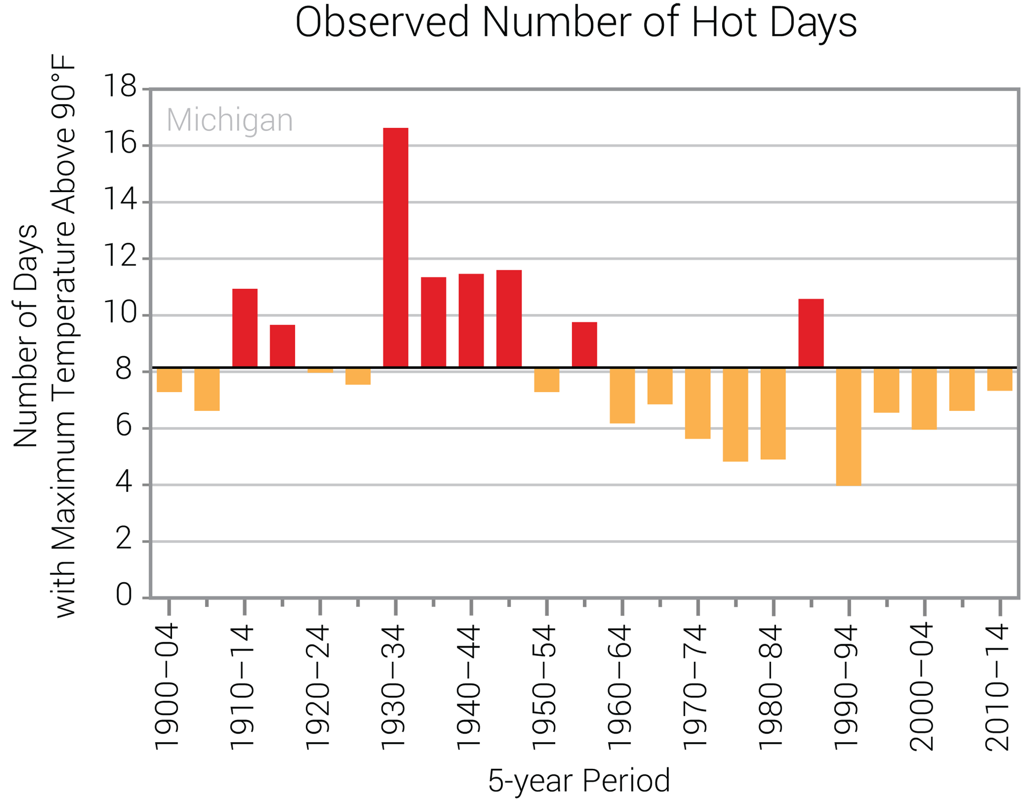
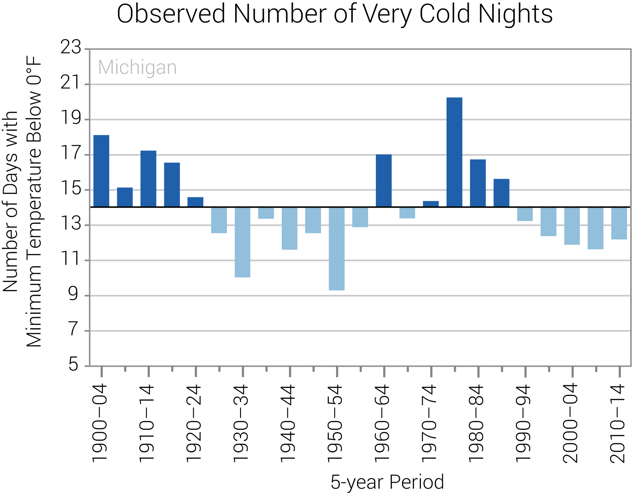
Since the beginning of the 20th century, temperatures in Michigan have risen more than 2°F (Figure 1). Temperatures in the 2000s have been higher than any other historical period. The year 2012 was the hottest on record for the state, with a statewide average temperature of 48.4°F, almost 5°F above the long-term average. This warming has been greatest in the winter and spring while summers have not warmed as much, a feature characteristic of much of the Midwest. This is reflected in a below average occurrence of hot days (maximum temperature above 90°F) (Figure 2a) and no overall trend in warm nights (minimum temperature above 70°F) (Figure 2b). The winter warming trend is reflected in a below average number of very cold nights (minimum temperature below 0°F) over the past two decades (Figure 2c) and reduced ice cover in the Great Lakes. From 2003 to 2013, the average annual maximum ice coverage was less than 43%, compared to the 1962–2013 average of 52%.
[/span6][span6]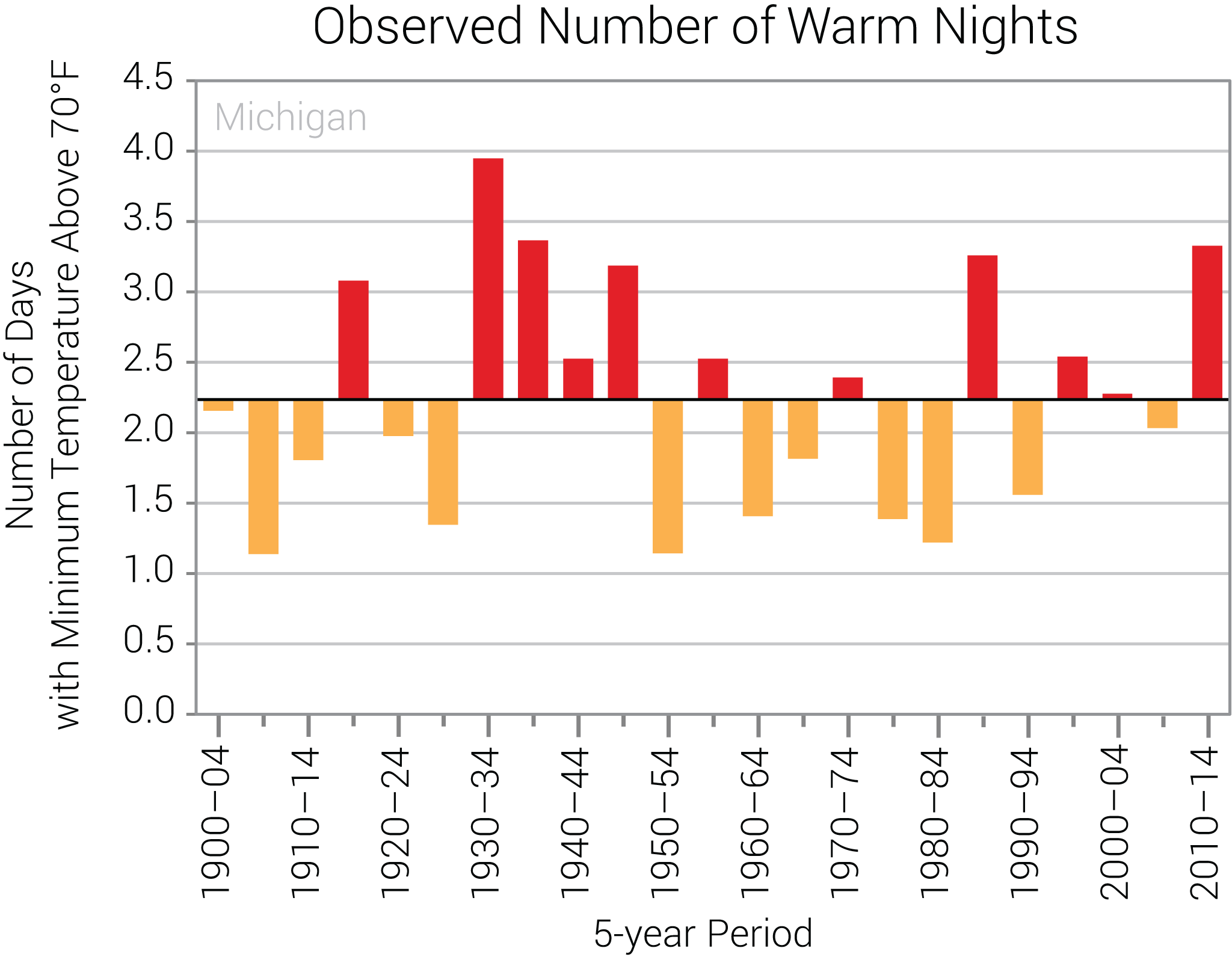
[/span6][/columns]
[columns] [span6]
[/span6][span6]
[/span6][/columns]
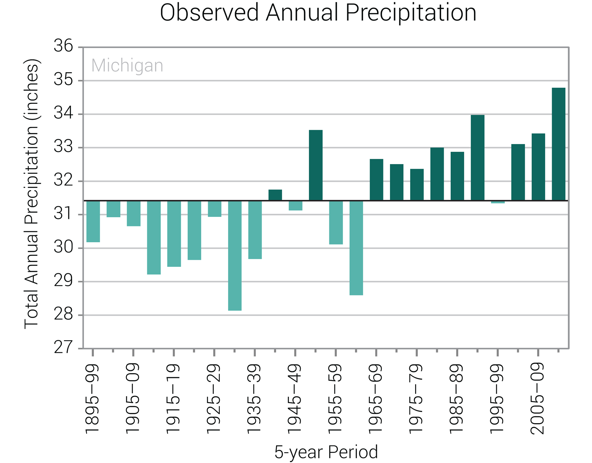
Statewide annual precipitation has ranged from a low of 22.68 inches in 1930 to a high of 39.22 inches in 1985. The driest multi-year periods were in the 1930s and early 1960s, and the wettest in the 1980s, early 1990s, and the 2000s (Figure 2d). The driest 5-yr period was 1930-1934 and the wettest was 1982-1986. The year 2013 was the second wettest on record, with the state receiving 38.23 inches of precipitation. Michigan has experienced an increase in the frequency of extreme precipitation events. Over the past decade, the state experienced the highest frequency of 2-inch rain events in the historical record (Figure 3). Snowfall is common in the state, but varies regionally. Due to the proximity of the Great Lakes, the south shore of Lake Superior in the Upper Peninsula and the eastern shore of Lake Michigan in the Lower Peninsula receive much more snowfall than the rest of the state. Parts of the Upper Peninsula receive more than 180 inches annually. The shorelines of Lakes Superior, Michigan, and Huron have experienced significant upward trends in annual snowfall totals.

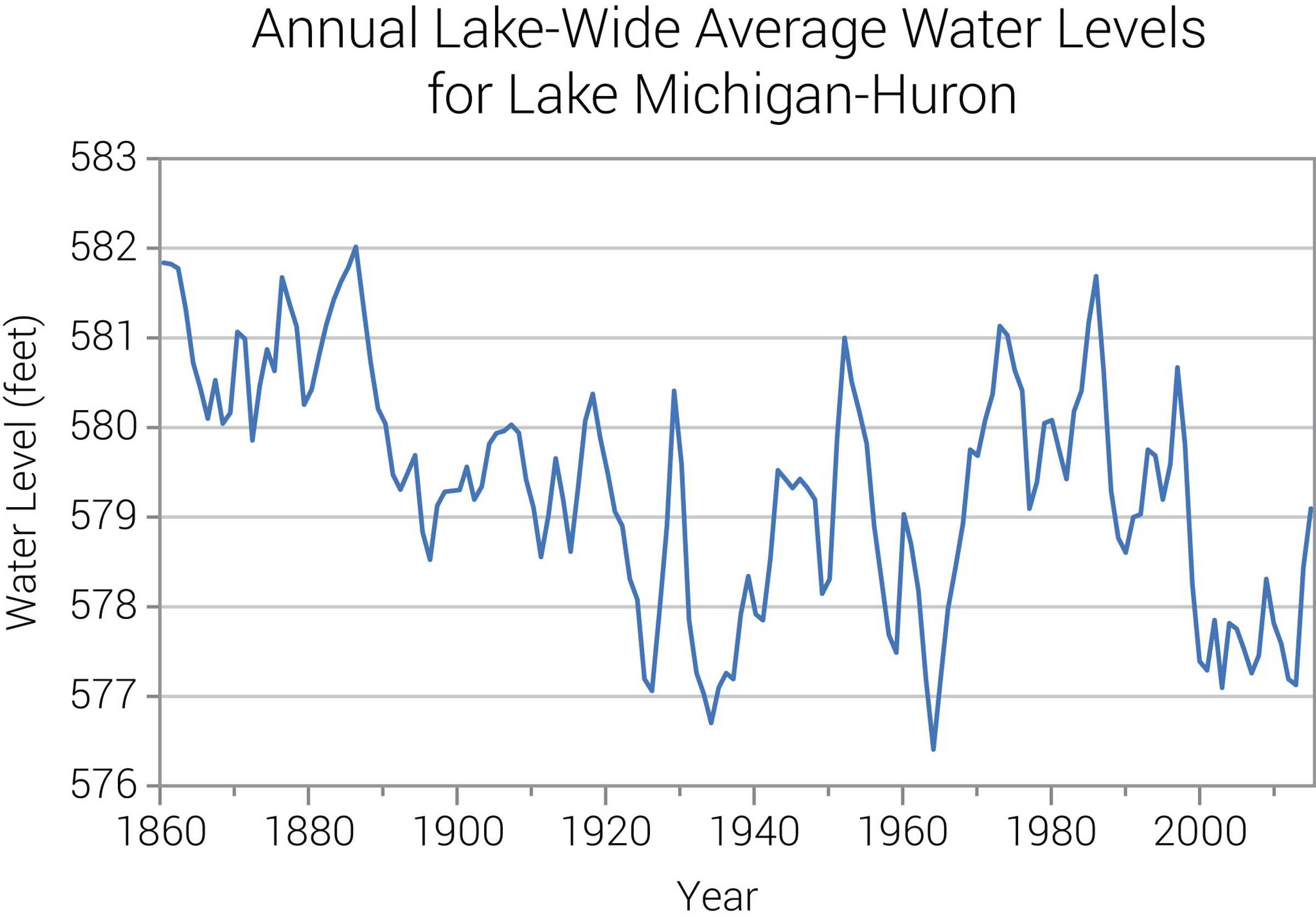
Water levels in the Great Lakes have fluctuated over a range of three to six feet since the late 19th century. Higher lake levels were generally noted in the latter part of the 19th century and early 20th century (the 1940s, 1950s, and the 1980s). Lower lake levels were observed in the 1920s and 1930s and again in the 1960s. For Lakes Superior and Michigan-Huron, the first decade of the 21st century has also seen lower levels. Trends on the lakes have been relatively small with the exception of Lake Michigan-Huron, which has shown a statistically significant downward trend over the past 150 years. The trend is largely due to the high levels early in the period and the extremely low levels in the past 10 years (Figure 4).
Large increases in temperature are possible for the future if greenhouse gas concentrations continue to increase (Figure 1). Even under a pathway of lower greenhouse gas emissions, average annual temperatures are projected to most likely exceed historical record levels by the middle of the 21st century. However, there is a large range of temperature increases under both pathways and under the lower pathway a few projections are only slightly warmer than historical records. Extreme heat is of particular concern for Detroit and other urban areas where high temperatures combined with high humidity can cause dangerous heat index values, a phenomenon known as the urban heat island effect. Higher spring temperatures will lengthen the growing season, but also potentially increase the risk of spring freeze damage. In 2012, the highest March temperatures on record caused Michigan’s fruit trees to bloom early. When temperatures dropped back down to below freezing in April, the budding fruit crop was destroyed, causing more than $225 million worth of damage, the worst losses to the state’s fruit tree industry since 1945.
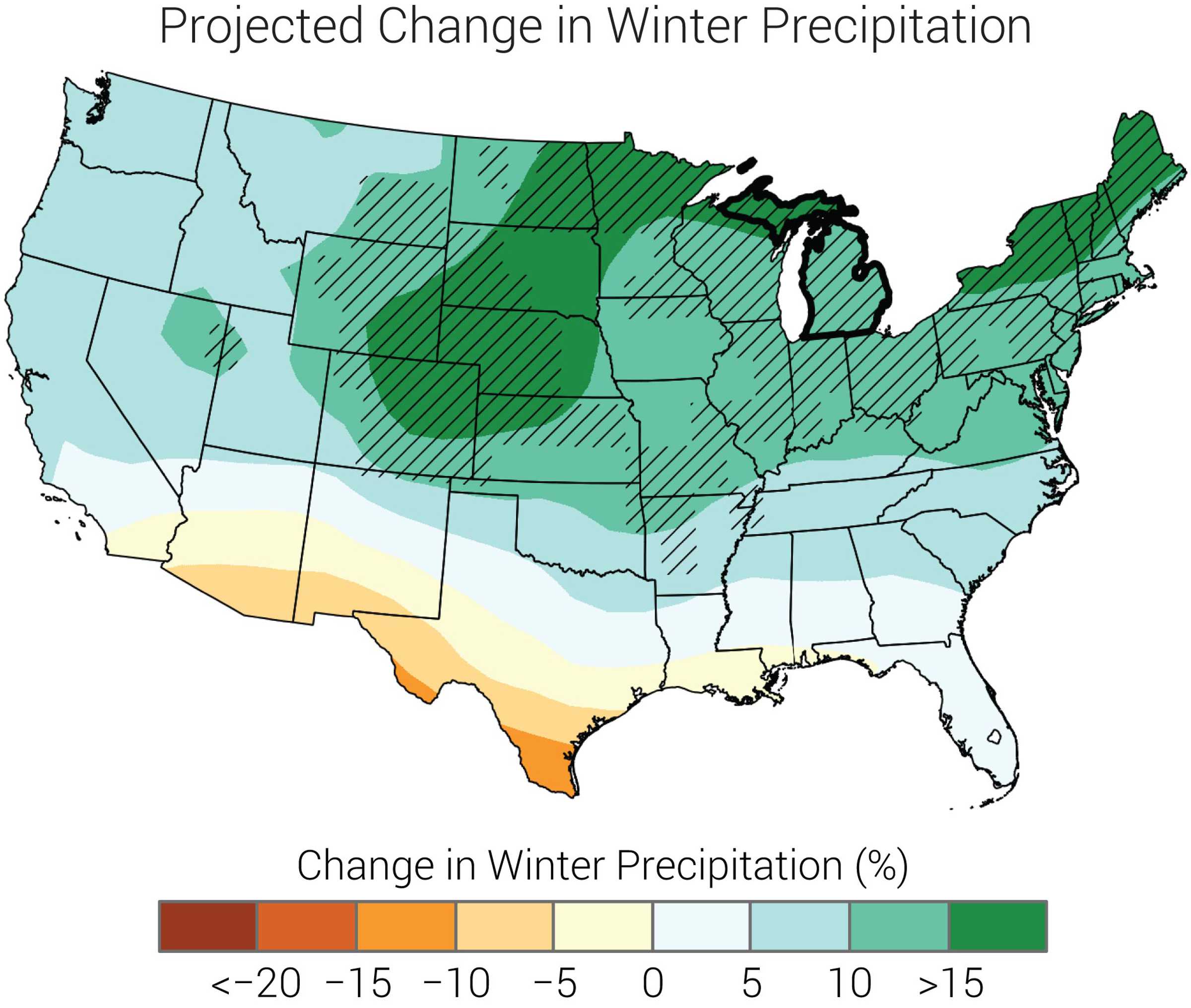
Precipitation is projected to increase for Michigan, with increases most likely during the winter and spring (Figure 5). Additionally, extreme precipitation is projected to increase, potentially increasing the frequency and intensity of floods. A greater frequency of heavy precipitation increases the risk of springtime flooding, posing a threat to Michigan’s important agricultural industry by delaying planting and resulting in loss of yield.
The intensity of future droughts is projected to increase. Even if precipitation increases in the future, rising temperatures will increase evaporation rates and the rate of loss of soil moisture. Thus, future summer droughts, a natural part of the Michigan climate, are likely to be more intense.
Changes in seasonal and multi-year precipitation, evaporation, and temperature can affect water levels in the Great Lakes, causing serious environmental and socioeconomic impacts. During the 1980s, high lake levels resulted in the destruction of beaches, erosion of shorelines, and the flooding and destruction of near-shore structures. Low lake levels can affect the supply and quality of water, restrict shipping, and result in the loss of wetlands. Future changes in lake levels are uncertain and the subject of research. Reduced winter ice cover from warmer temperatures leaves shores vulnerable to erosion and flooding.
Too cool! The Blue Angel’s will own MI airspace tomorrow. Check with local news for potential flyover times for your area. I do hope everyone gets the chance to hear an F18 rip over head tomorrow…nothing like it. Blue sky and Blue Angel’s. Good luck everyone.
The exact times have not been announced yet. They will be posted here:
https://www.facebook.com/127thWing/?fref=mentions
Looks around 3 ish over GR ……way cool. ..INDY
Hey INDY, Mr N and Mark, the around 3:00 time is when the A10’s from Selfridge AFB will fly over our area. The Blue Angels would be a few hours earlier. Not sure if we’ll be able to see them in Kent County because they are doing flyovers in Detroit, Chicago & Indianapolis tomorrow, so their flight path will probably be south of us. But if anyone is up for a road trip it looks like they will be over Detroit sometime during the 11 am hour.
You can also download the plane finder app on your phone and track all flights in your area. It actually shows every flight in the air right now in The US. So you’ll be able to track The Blue Angels on it tomorrow.
https://planefinder.net/apps
Way cool thanks Andy! INDY
Back to currently and normal weather outside its 44* degrees out at thee YARDofBRICKS NE of GR 25* degrees below normal for mid May standards huge numbers ….Will we even hit 45* degrees today ??? INDY
49 at Ford Airport currently. The past seven days have been chilly, no doubt.
European & GFS models are both giving Lower Michigan 80’s next week now. I love it!
Great news it’s been a long time since we hit 80 or better in May!! Some will consider that hot on here I bet lol…INDY
We hit mid 90’s in May less than 2 years ago. I’m not sure what you’re talking about. Bring on the above average temps!
For the past two weeks, Bill’s Blog has been talking about the “record cold” and snow that we never got. Will he talk at all about the upcoming warmth? Still nothing… hmmm
Blowtorch warmth coming for Lower Michigan says this article this afternoon. Get ready!
https://www.washingtonpost.com/weather/2020/05/11/weather-pattern-change/
Only 38* degrees currently out at thee YARDofBRICKS NE of GR for 1pm that’s cold 20 degrees below average we won’t even see 10+ degrees average in the 3 month summer ahead I bet crazzy ….INDY
At this time, it is cloudy here at Grand Rapids with a temperature of only 41. Across the state temperatures run from just 32 at the Sault to 44 at Marshal. In the UP and northern lower Michigan temperatures are stuck in the 30’s even with full sun.
https://www.exploremunising.com/web-cams/
and
https://www.mtu.edu/webcams/
Well it is time for me to put on my winter coat and go for a walk.
Slim
Talk about a cold mid May day! Wow!
Well, it looks this cool snap is on it’s way out (finally) after this week. I probably shouldn’t jinx us, but I have not seen any frost the past several mornings. My bro in Phoenix has been enjoying upper 90s to mid 100s for more nearly four weeks. He’s one lucky dude.
100’s? That sounds absolutely horrible! I would never live in Southern AZ! Sounds horrible!
Very low humidity. Bro said it hasn’t been too uncomfortable.
There is a good chance of frost tonight. Back in 1992 it was also hot in the SW and here we had one of our coldest summers that year.
Slim
Wednesday will be the 40th anniversary of the Kalamazoo Tornado that cut right through downtown killed 70 I believe!! Way maybe getting some good storms around here soon with the temps going up …INDY
Well it looks like we are likely done with accumulating snow for the season. Did we even break 50 inches in GR??
Barely! No snow for probably 6 months or more after a very weak winter. I love it!
Yes well above 50 inches in GR!
About half of what you predicted this year, huh Bud?
Get ready for the cold nights that are coming! Get prepared now!
The cold weather posters are getting restless on this blog I see. Always happens when we’re in for a big warm up! Must be disappointed we didn’t see any of that 2-4″ of snow that was mentioned. No snow until October or November. I love it!
February was pretty active month we had 3 winter weather advisory’s and a Winter storm watch in Grand Rapids ….INDY
If only every winter was mild and snowless like the last one! Now let’s hope for another warm summer! We are going for our 4th straight warm year!
While last winter was indeed mild and there was much less snow fall then average GR did record 53.5″ of snow fall so I would not call that snowless. In fact that would above average snow fall for many locations at our latitude.
Slim
Rock on slim and thanks for the facts! This helps tamp down the warm weather hype that mookie constantly spews!
Hyperbole, Slim. Obviously, it snowed last winter LOL Just wasn’t much snow at all compared to what we’re used to. C’mon now.
So the King of warm weather hyperbole speaks! What a joke!
36* degrees currently out at the YARDofBRICKS NE of GR for mid May May 11th to be exact that’s cold ….INDY
100% correct!
The below normal temp Spring just keeps rocking! More freezing temps tonight and tomorrow night! The average high temp by the end of this week is 70 degrees, so if we are lucky we might get back to normal by the weekend! The cold pattern is incredible!
Say that again our furnace like most have been running for 8 months straight now … Crazy….INDY
Not Mookie, he/she has not had theirs on for several years now (LOL)
Slim
You know it and we are clearly in a cool Spring pattern! Those pesky little facts get in the way of the warm weather hype all the time!
You mean the fact that we’ve had 3 warm years in a row? Hmmm Or the fact that last winter was mild and snowless?
One week of chilly temps after a warm start to 2020. Nothing unprecedented. We didn’t even set any record lows! And it will be over in a few days. I love it!
Facts>>>>>April = below normal temps! May is heading for below normal temps! The pattern is clear!
So was the pattern clear when January, February, and March were all above average temps? I don’t recall you talking about those months LOL
Has anyone heard of how the fruit crop handled the freeze? I have not seen any reports.
Slim
Not much, if any, damage. Much of it was over-hyped:
“Robinette says weather like this isn’t unprecedented and farmers will adapt even if that means relying on larger farms or adjusting their operations like closing u-pick. He doesn’t think the impacts of this freeze will be like the ones in 2012 that left Michigan with less than 10 percent of an apple crop, explain growers saw three to four days of low temperatures then whereas this time around it looks like it will just be a one time freeze which should be more manageable for orchards and fruit farms.”
https://www.fox17online.com/news/local-news/west-michigan-growers-deal-with-aftermath-of-late-season-freeze
If I remember right 2012 we had temps in the 80’s in March unheard of everything bloolmed fast and by April it got cold so that probably would do more damage because crops are not supposed to bloom in March correct in Michigan…. Not so sure where the over hype comes in when there is a frezzing warning out for tonight just basically unherd of in the middle of May that’s sounds more hyper to me lol yes if your a farmer please prepare tonight….INDY
Yes 2012 it got real warm in March and back to near average in April and that did cause a lot of damage. This year it has been cold from mid April to now so things are running later so there may not be as much damage.
Slim
Back in May of 2017 there was this report on the freeze that year.
https://www.michiganfarmnews.com/fruit-frost-damage-assessments-underway
Odd thing is while this year the lows in GR, Muskegon and Lansing were in the low to mid 20’s In 2017 the lows were just 31 at GR and Muskegon and 28 at Lansing.
Slim
It usually takes 10 to 15 days to come out after the fact and with tonight’s frezze and Wednesdays possible frezze it maybe awhile … crazy we are still talking about this in the middle of May slim …INDY
I see that it will take about two weeks to see what damage there is.
Slim
Let’s hope for the best ..I’m thinking another year with no lilacs out at the yard bricks our bush is cooked ….INDY
The first 10 days of May 2020 will go down in history as cold and some what dry. The mean here at Grand Rapids for May 1st thru the 10th is 48.2° and that is a departure of -7.1°. For a comparison the average mean for Grand Rapids for the month of April is 48.0 so the first 10 days have been more like a continuation of April. There has only been 0.21” of rain and a trace of snow was reported. Today’s forecast high of 47 will once again put today as one of the coldest maximum for this… Read more »
Frezzing warning again tonight temps 20 degrees below average will be the big story for May now.. Like slim was saying we don’t feel this that often in a lifetime crazzy..May showers bring June flowers is the saying around here now forget April showers because we are still shoveling snow lol….Have a super but warm Monday keep the fire burning …INDY
Wow, that is a pile of stats and data today MV! Love reading that stuff. It would be nice if the charts showed the more recent years instead of up to 2014, but still great info. No doubt in recent years our rainfall has increased dramatically, especially during our milder Winters.
The total rain fall reported at GRR for 2015 33.11″ for 2016 46.29″ for 2017 39.43″ for 2018 44.45″ 2019 51.37 that is a record for GR. And this year so far 12.42″.
Slim
Thanks for that wealth of weather info… Climate change is not unlike a large novel… what do the next decades have in store for us? Turn the page…
Big warm-up ahead: “Temperatures will rebound into the 60s by Wednesday and Thursday and then 70s by the weekend. This trend looks to hold into next week, too.”
Yep, looks by the weekend GR will be back to near average for this time of year.
Slim
Wow it’s been awhile….INDY
LOL It’s been a week of cooler air. Nothing big. CPC thinking we go above average temps in the extended forecast!
Yep, come June, July and August and temperatures reach into the 90’s no big deal. It happens almost every year.
Slim
But heaven forbid, we make a top 5 or top 15 maximum cold day in May and it gets hyped for over a week. I will remember that in the summer LOL
Your so right slim..Yes mokkie let us know when we have temps in the summer 20+ degrees above average that could be a heat wave then a real heat wave. ….INDY
Welp, no record lows. No snow. I love it!