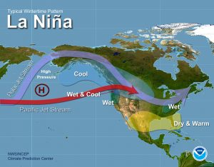
With what looks like could be a weak La Nina or natural state developing for this up coming winter lets take a look at what happened in (going back to 1950) here in Grand Rapids in the winters that were weak La Nina and neutral years (not El Nino or La Nina)
Here is a list of weak La Nina years since 1950 and total seasonal snow fall at Grand Rapids
1. 1954/55 78.3”
2. 1964/65 101.4”
3. 1971/72 79.8”
4. 1974/75 68.9”
5. 1983/84 71.4”
6. 1984/85 69.6”
7. 2000/01 98.1”
8. 2005/06 69.2”
9. 2008/09 104.4”
10. 2016/17 60.1”
The long term snow fall mean for Grand Rapids is 75.7” the range (since 1950) for a La Nina winter season is between 68.9″: and 116.0” with the average of the weak La Nina years is 80.1” So about 4.4″ above average.
And here is a list of neutral years (as best as I can tell)
1. 1959/60 90.7”
2. 1960/61 87.9”
3. 1962/63 89.7”
4. 1966/67 91.8”
5. 1967/68 55.1”
6. 1978/79 96.0”
7. 1980/81 51.5”
8. 1981/82 74.5”
9. 1985/86 79.1”
10. 1989/90 89.8”
11. 1990/91 60.6”
12. 1992/93 65.3”
13. 1993/94 76.6”
14. 1996/95 79.7”
15. 2001/02 105.2”
16. 2003/04 74.0”
17. 2012/13 66.0”
18. 2013/14 116.0”
In the neutral years the range has been between 51.5” and 116.0” and the average is 72.3” So bottom line is that based on a weak La Nina or neutral West Michigan has a good chance of seeing snow fall in the average to above average, with a range of 51.5” to 116.0”
In looking at the January’s of the weak La Nina years the coldest was 18.3° in 1972 the warmest was 32.6° in 2006. The average mean for the La Nina January’s is 24.9° the January average here in Grand Rapids is 22.9° so in the weak La Nina winters January comes out at +2.0°
The range of the average temperatures in January of a neutral winter are 15.8° in 1963 all the way to 32.0 in 1990. The average of the neutral January’s is 22.2° so in the natural winters the departures on average is -0.7° So based on the past if this winter is a weak La Nina or in the neutral area we still have the best chance of seeing a near average winter. So take all of the guesses that you hear about a lot of cold and snow with a grain of salt. Heck it could be cold and snowy (2013/14, 1964/65) or it could have little snow and mild (2016/17, 1980/81) My guess for this winter is near to below average snow fall and near to above average temperatures but it will be up to Mother Nature to decide.
Big fall storm in November this year? But while not guaranteed there is a chance of a big fall storm 15 to 20 days out. Think big time November storm. I would call this a “heads up” advisory. Some think this will be a flip into a long hard winter pattern. I will not say that. But I will do some research and see if I can find a year with a hot September warm October that led into a cold snowy winter. Right now I have not seen one
Well John Dee has his winter “guess” out for the upcoming winter.
http://johndee.com//seasonalfcst/2017-18/seasonalforecast.htm
As he states take all winter guesses with a grain of salt.
and there is this
Here is a kind of fun map to look at it comes from save energy.com check it out.
https://www.saveonenergy.com/climate-equivalences/
Slim
3.66″ of rain today by 9 PM here at Gun Lake – with the heavy stuff just about to start. I guess I can put my sprinkler away for the year….LOL!
So far here at my house I have received 0.33” of rain for this event. Right now I have cloudy skies and a temperature of 59°
Slim
Now at 1.06″ of rain for this event. Light rain here with a temperature of 61°
Slim