After cold morning temperatures, dry weather will continue into Sunday, with a good deal of sunshine for much of southern Lower Michigan. The next chance of lake-effect snow showers arrives for late Sunday night into Monday night, with light accumulations possible in areas near the lakeshore. Temps will be in the low 20s north and near 30 in the southern three tiers of counties.
We currently have 2° at 5:30 am with clear skies. Yesterday we made it to 21° after a morning low of 5°.
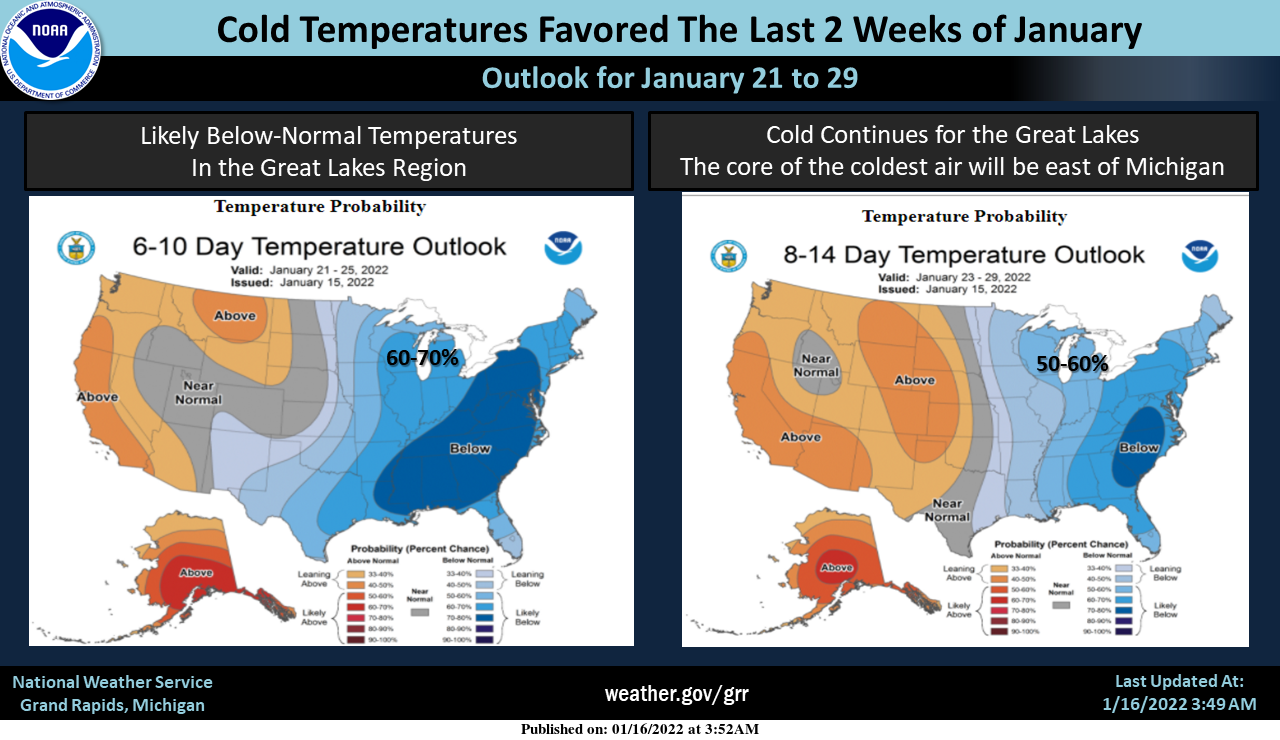
Temps will remain below normal for the rest of the month with precip at or below normal. Chances of precip this week remain in the 20 to 40 percentile for the first half of the week.
Last year at this time we had below-normal snowfall. I wrote on the 16th of last January, We will once again see the oddity which is snow in the state today. We have had 2.5 inches in Otsego so far for January and 8.2 inches since December 1st. I thought last year was bad as we failed to reach 40 inches for the winter season. Like last year we are getting inched to death with mediocre amounts from synoptic events and lack of lake effect due to lack of Arctic air. We had a high temp of 43° yesterday. We currently have rain and 34° at 7 am.
We have had 23 inches of snow this season well ahead of the past couple of years. This year we have had mainly lake effect with a couple of synoptic events where we didn’t much lake effect the past couple of years. We are losing ground since we haven’t had any precip of note since January 8th.

This is the Hunga Tonga volcano in the small island nation of Tonga in the Western Pacific.
Tonga's Hunga Tonga volcano just had one of the most violent volcano eruptions ever captured on satellite. pic.twitter.com/M2D2j52gNn
— US StormWatch (@US_Stormwatch) January 15, 2022
Forecast Discussion
- Some lake effect still poised for Tonight/Monday

The forecast generally remains unchanged with good continuity
regarding the arrival of some snow showers for tonight and through
much of Monday. We continue to think that we will not see
significant accumulation by January standards.

We will see mainly clear skies this morning, before mid and high
clouds arrive through the day. Snow showers are expected to hold off
pretty much until 00z or after for the NW areas, and later further
South and East, if at all. It is at that time that an upper short
wave arrives, and colder air at the surface.

Most of the snow shower activity will be of the lake effect variety,
as the upper trough runs into the storm system bringing the wintry
weather to the srn and ern portions of the country. A bit of ridging
aloft holds on over the area with the main low over the NE. Lake
effect parameters are marginal with the 850 mb temps around -10C
(delta t`s around the 13C threshold). Forecast soundings indicate
that inversion heights will keep the top of the convective layer
around 5k ft, even with the lake modified parcels.

The flow will become mostly NNW, keeping the snow showers limited to
the coast. We could see a couple of inches or so by the time things
wind down later Monday for the favored NNW flow areas. We do not
anticipate needing headlines for this event at this time.

- Better chances for lake effect Wed through Fri with colder air

We will see a break in the precipitation develop Monday night and
last into Tuesday. Some light snow remains possible up along U.S.-10
in the warm air advection occurring ahead of the next incoming low
that will track north of the area. Other than that though, not much
precipitation until late Tuesday night/Wednesday morning.

The cold front is expected to push through the area roughly between
06z and 12z on Wed. Good cold air advection will take place, and
lake effect should get going by Wednesday afternoon as the over lake
instability becomes sufficient. We will see a boost in the activity
Wednesday evening and night as a well defined short wave approaches.
The flow aloft then becomes cyclonic, and forecast soundings show
modified inversion heights over 10k ft.

The flow continues to look to be in a NNW orientation once again,
favoring the lakeshore. Instability will be moderate to extreme with
850 mb temps dropping to around -20C. Conditions will become less
favorable for good accumulations by Thursday morning as inversion
heights drop a little behind the short wave, and the DGZ drops down
to almost being below the cloud layer. This will produce a finer and
small flake. We could see this event needing a headline
eventually. The snow showers will then slowly taper off on Friday.

Quite a bit of uncertainty exists beyond Friday, with additional
energy coming into the picture. Last night, it looked like the upper
trough/cyclonic flow would move out and give the area a break. Now,
there is another feature that will be in the region, and could bring
some additional synoptic snow. One thing looks for sure though, and
that is we will be colder for most of the next week.
We had some big storms come through here in Florida today. I am pretty certain I saw a wet microburst based on radar and visual observation. It was pretty cool!
WOW, we are entrenched in a below normal temp pattern and no change in sight! Incredible!
GREAT NEWS>>>>the latest CPC shows below normal temps as far as the eye can see! Get ready for cold, lake effect snow, lake enhanced snow, clippers and synoptic snow! I love it! Rock n Roll will never die!!!
Below average snow continues! Loving all the sun today. The birds are out. Little higher sun angle. The snow melting. You can almost feel spring on the way!
Great winter so far! Cold and snowy! Above normal snowfall in November and we are running above normal for January so far with tons more on the way! Who would have thought? Keep it rocking!
Warmer today what highs in the 20’s lol….currently 1* degree outside shivering snowmans loving the fact that we are close to a month straight with snow covered fun in west Michigan and with more snow coming this week who would of thought ???????????????????????????…Indy
To me it looks like very little snow for GR for the foreseeable future but cold.
Slim
Halfway point of Winter and we are officially below average for snow for both met Winter and the season as a whole. I’ve had our business lot plowed a total of 4 times so far, well below the 30+ year average of 16 times by this point.
I have only shoveled once. Outside the one event, any snow that had fallen was gone within a day or two.
Grand Rapids has reported at least 1″ of snow on the ground for the last 20 days in a row. Lansing reports 0″ of snow on the ground as of now.
Slim
With clear skies the overnight low so far here has been +2. It was a kind of rare January day here yesterday with a reported 100% of sunshine. While there is a chance of some snow it still don’t look like it will be a lot of snow here in Grand Rapids and to the east. Most of the snow this next week with be near the lake shore in a NW flow.
Slim
We are currently in a deep freeze have enough snow on the ground for Winter fun and the inland lakes are frozen this is dandy of a winter on going in west Michigan!! InDY