
We are now 2/3s of the way through meteorological summer with a lot of 80 plus degree temps and a couple of stretches of 90° stretches thrown in. We have received only 2.33 inches of rain in Otsego this month which is about an inch below normal. We started out with a wet June so we have 6.39 inches thus far this summer.
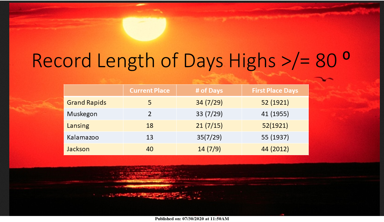
This has been an unusually persistent warm summer for Southwest Michigan. Many locations in Southwest Michigan are in the top 10 for length of days in a row with highs of 80 degrees or more. Muskegon is in second place with 33 days, behind the 41 days in 1955, as of the 29th. At Grand Rapids, the 34 days, through the 29th puts us in 5th place. With highs forecast to be in the 80s through Saturday, the length is expected to increase.
I am sure we will see plenty more 80s through the month of August into September, however it is likely we will descend into our usual prefall pattern. I am thinking a warm start August then cooling towards the end of the month. Sorry, no snow is forecast or frost for that matter – we still have to wait until October for that to materialize.
Next week we will see our temps in the upper 70s which is something we haven’t seen for a while.
Forecast Discussion
– Most areas stay dry today and Saturday
– Greatest risk for rain Sunday, mainly east of US 131
– Some showers may continue developing Monday into Tuesday
-- Most areas stay dry today and Saturday --

Models are not supporting more than an isolated shower over the
next couple days as dry NE flow from the surface to 850 mb is in
place. HREF guidance suggests very low probabilities for any
location getting measurable rain through Saturday evening.
Afternoon lake breeze development could touch off an isolated
shower or sprinkle but that would be about it.

-- Greatest risk for rain Sunday, mainly east of US 131

WV imagery is identifying the system of interest currently
centered over the KS/MO line. This area of low pressure is
forecast to slightly deepen as it takes a path from southern IN to
north central OH by late Saturday night and into Sunday morning.
There seems to be a clustering of solutions now that would favor
the greatest rain chances to be east of US 131 beginning late
Saturday night into Sunday afternoon. The ECMWF, GEM, and UKMET
are in agreement on this scenario but the GFS is slower, deeper,
and further northwest with this system and as such there would be
a deformation band of rain between US-131 and US 127.

Our current QPF may be too skewed by the GFS and hence overdone
for much of the area. It seems the best chance for a "soaking"
type of rainfall would be confined to south central and SE Lower
MI, especially metro Detroit. Ensemble analysis for >50% chance of
a half inch or more of rain as follows: GEFS - near and east of
US 127; CMCE - east and south of a line from Holland to Mt.
Pleasant; ECM - southeast of the MI/OH state line. While highest
probabilities will likely be confined to south central and SE
Lower MI, there are still some ensemble members (especially CMCE)
that provide heavier rain for much of central and SW Lower MI on
the order of one inch or more. While this is a less likely
scenario, it is a non-zero risk.

- Some showers may continue developing Monday into Tuesday

Areas that miss out on rain Sunday will have a second chance
Monday. There is good model agreement that a 500 mb trough and
significant thermal gradient at 850 mb will be progressing through
Michigan on Monday. At the surface, a cold front is forecast to
move through Lower MI during the day. The ECMWF is suggesting some
decent sfc wind convergence during daytime heating which could
enhance shower and thunderstorm development across central Lower
MI, moving south with time. Some of this activity could linger
into Tuesday.

A drying trend is foreseen for the midweek period. High
temperatures Tuesday into Wednesday will be the coolest we have
seen since June 23 to 25.
I love these summers with basically no heat waves! Incredible!
Wow wood tv 8 this morning says fall like temps coming with the month of August and so is September by far the best statement of the day on this weather blog …INDY …
In most years August has some fall like temperatures. The truth be told Michigan has a rather short period of very warm temperatures. It will be nice for the next 2 to 2 and a half months before it becomes cloudy and cool on many a day.
Slim
The official overnight low at GRR looks to have been 61. Here at my house the overnight low was 60. With clear skies the current temperature here at my house is 65. 7 of the last 11 years July has been much warmer than average. (that includes this year) with 2 near average and 2 below average.
Slim
It also looks like every day in July will have been between 80-94 degrees. I love long hot summers!
If today reaches 80 (it should) this will become only the 2nd time in recorded history that Grand Rapids has reached 80 or better on all 31 days in July. The other year was 1955 with a range of between 80 and 97. 4 other years have had 30 days that have reached 80 or better and they are 2012, 1988, 1921, and 1916. Down at Kalamazoo they too should have all 31 days reach 80 or better it has happened there a total of 7 times so this will be the 8 July that it has happened there.
Slim
Well, with one day to go and a balmy current July mean of 75.9 degrees, it looks like this will be the hottest July since 2012 and one of the top 3 hottest July’s in the past 30 years.
Thanks for the stats MV! It has been a long stretch of hot weather this year. In addition to the records and near records around the area, there are also records being set out on Lake Michigan for water and air temps. Our electric bill the other day was the highest we have ever had other than 2012, worth every penny.
Bill had a good piece of all kinds of air/water temperature records being broken on Lake Michigan this summer. It’s been incredible!