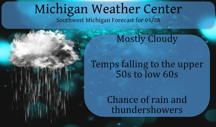
After a sultry 83.7° for a high temp yesterday we have fallen to a warm 67° at 5 am this morning which is near our normal high for this time of year.
Isolated strong to severe thunderstorms are possible early this morning with isolated hail and isolated damaging wind gusts possible. Showers and a few storms will persist Today into Thursday, followed by dry weather to end the week.
Currently, most of the heavier rain is present north of Big Rapids with a few sprinkles out over lake Michigan – chances of rain today are 50/50.
Weather History for SE Michigan
April 25
On April 25, 2009, A strong cold front pushed into Southeast Michigan during the afternoon hours, producing several severe thunderstorms, generally confined to the M-59 Corridor, where tree damage and power outages were most prevalent. Over 50 severe reports were recorded with most of those being wind damage and severe wind gusts as high as 70 m.p.h. There were 80,000 homes and businesses which lost power in Oakland county.
Also on April 25, 1990, the temperature rose to 87 degrees in Flint. This set the record for the high temperature in the month of April in Flint and was tied by the records set on April 16, 2002 and April 18, 2004.
April 26
On April 26 2009, it was a sunny and very warm day with a record high of 86 set at Detroit.
April 27
On April 27, 1915, the temperature in Detroit never dropped below 65 degrees. The temperature never dropped below 65 degrees the day before (April 26) as well.
April 28
On April 28, 2011, heavy rain that started on April 27 continued across Southeast Michigan. All locations received over an inch of rain during the two days, but many locations in the Saginaw Valley and Thumb had over 3 inches. Several roads in the Thumb region were closed. This rainfall helped to make it the third wettest April in Saginaw, the fourth wettest in Detroit and the fifth wettest in Flint. The wet April assisted in making the spring of 2011 the wettest in Flint history, second wettest in Detroit, and the eleventh wettest in Saginaw.
Also on April 28, 1986, an F2 tornado hit Saginaw county at 2:33 pm which cost $2.5 million in damages.
April 29
A very impressive late-season rain/snowstorm hit Southeast Michigan late on April 28th – 29th in 1909. The very intense low-pressure system moved through the region bringing Detroit 1.99″ of rain along with 3.0″ of snow, sleet and hail from thunderstorms. Easterly winds gusted up into the 40s mph much of the 29th and then late in the evening, a strong cold front brought a northwest wind gust to 54 mph. In Saginaw, they were buried under 13.0 inches of snow.
April 30
On April 30, 1962, 2 simultaneous F1 tornadoes hit Washtenaw County at 6:00pm.
On a dry weather note, the date concluded one of the driest (4th) Aprils on record in 2004 when just 0.69″ of precipitation fell (0.70″ at Flint made April 2004 the second driest on record). One has to look back nearly a century to find a drier April (0.66″-1915) in Detroit.
May 1
On May 1, 1983, the county of Monroe was hit by an F1 tornado that tore through the county at 11:55PM. It caused about $3,000 in property damage.
Weather History for SW Michigan
April 25
1976: Winter returns after summer-like weather the week before. After four days in the 80s from the 15th to the 18th, temperatures are held in the 30s today and heavy wet snowfalls. Lansing sets a record for the date with 4 inches of snow, as does Grand Rapids with 3 inches.
April 26
1915: A record three-day spell of warm weather in the 80s peaks with a high of 88 degrees at Grand Rapids and Lansing
April 27
1966: A cold rain falls across Lower Michigan, holding temperatures in the 30s. The high of 37 at Grand Rapids and 38 at Lansing are both record cold high temperatures for the date.
April 28
1964: A tornado destroyed a cottage and downed trees north of Newaygo.
1991: A restaurant was destroyed and a hardware store was unroofed as a tornado moved along the northwest edge of Hart in Oceana County.
April 29
1899: Grand Rapids sets the record high for the month of April at 90 degrees after a balmy morning low of 70 degrees.
1909: Heavy rain mixed with snow sets records across Lower Michigan. The daily total liquid-equivalent precipitation is 2.53 inches at Grand Rapids, and this includes a daily record of 2.2 inches of snow. The 1.75 inches at Lansing includes four inches of snow. Temperatures remain in the 30s all day.
April 30
1962: Several tornadoes struck southern Lower Michigan. A fire station was damaged in Lansing and a building was destroyed in Grand Ledge. Another tornado struck south of Ypsilanti destroying a barn and damaging two houses.
May 1
1966: A May Day snowstorm drops 4 inches of snow at Lansing.
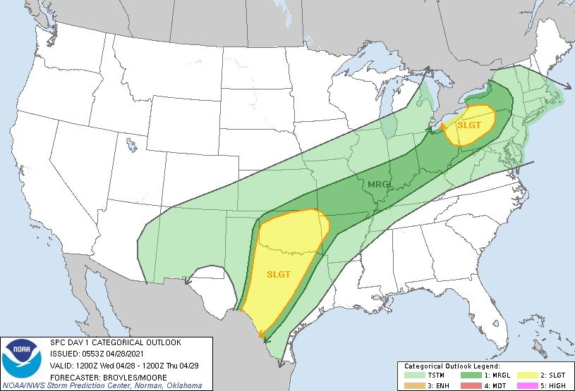
SPC Outlook for Today
Forecast Discussion
-- A chance of showers today and Thursday --

Sfc analysis shows a frontal boundary extending from eastern Iowa
through the central CWA. Temperatures are in the 70s south of the
front and lower 50s north of there. Radar reveals the pcpn is
farther north along the h8 front from northern Wisconsin to near the
Straits. Short range models indicate that we could still see some
showers as the h8 front moves through later today. A thunderstorm
may be possible south of I-94, but severe storms are not expected.

The sfc front will move south today and we`ll see cooler highs than
yesterday, except in the far southeast which may flirt with 80
again.

Tonight will be dry and then rain chances will increase again
Thursday as a wave of low pressure rides northeast along the front.
Unlike today, there`s much better upper support via a well defined
short wave. The ECMWF clearly shows some deformation type showers
well north of the sfc low that moves across Ohio. The NAMNest also
shows this.

-- Cooler through Friday, frost Friday night--

Once the sfc front moves through cooler air will flow back into the
state. Highs Thursday will be in the lower 60s and the mid 50s
Friday. If we can clear out Friday, we`ll likely see some frost
Friday night as temperatures fall to around freezing.

-- Another chance of rain Monday --

Rain chances will increase late Sunday into Monday as another cold
front moves toward the state. Looks like pretty good moisture return
from the Gulf. Similar to this week, next week`s cold front will
hang up near the CWA and another wave is progd to develop on the
front. So rain chances will linger into Wednesday. The ECMWF
develops an inverted trough across the Corn Belt Wednesday which
would bode well for rain chances here.
58 in GR but sunny and 73 here. We received about three drops of rain midmorning and that’s all.
62 and sunny here. Just the perfect weather! We only had about 5 drops of rain here. It is getting incredibly dry around here. Dust is blowing off the fields.
anyone know why a raingauge beaker would have measurement increment marks (in inches) that are not accurate when compared to a ruler? fyi…The beaker is not graduated. ie… 1 inch in the beaker is equivalent to about 1.4 inches on a ruler. It is a Lacrosse gauge.
54* degrees in my area did a cold front come through wow ….INDY
Got rid of my snowblower last weekend, dropped it off at a recycler. It mostly sat in my garage collecting dust and taking up space the past 3 years or so! I can count on my one hand how many times I used it over that time span! Maybe someone in the UP can get some good use out of it!! LOLOLOL!!
You better buy a new one and a large one for next winter, because we will be getting pummeled with snow! It could be record setter and tons of fun!
Hahahaha!!! You have said the same thing over the last 3 years!!
Mark it down and take it to the bank!
I can’t remember the last time I only needed to mow one time the entire month of April! It just goes to show how cold the back half of April has been! Get ready – more 30’s are on the way! Incredible!
Yeah, if you don’t care how your lawn looks, with weeds and long grass, mowing once in April is fine. But I’d rather keep my lawn looking fresh and manicured, that’s why I’ve mowed a few times already.
Warm morning is right. It was 68 here when I got up. Need rain. Please, let it rain.
Had to mow yesterday for the 4th time already. Can’t ever remember mowing this much in April before. Already used the mower more this month than I used the snow blower all Winter.
I have mowed a whopping one time!
Yes, some people don’t mind if their yard looks like an overgrown mess.
Cut the grass for the first time this Spring season yesterday I’m waiting to put seed down I don’t want to see any 30’s for lows anymore Hopefully May!! ….INDY
Better wait then. More 30’s are on the way.
Get that seed ready on Saturday INDY! Bring it on!
Im ready .. My yard needs it ..INDY
Getting some light rain here at this time. The temperature has now fallen down to 55 with that light rain. While the high here at my house yesterday was 82 the official high at Grand Rapids was 78. Either way using the rule of April 27th this summer should be either cooler or near average.
Slim
Getting a nice Light Show Up North.
http://www.lightningmaps.org/?lang=en