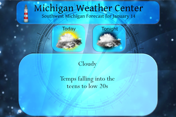
We are currently 31° at 5:30 this morning which will be about as high as we will go for today. Yesterday’s high was a balmy 36° and the low was 31°. Today we will be mainly cloudy, with temperatures falling to around 21 by 5 pm. An east northeast wind of 9 to 14 mph will bring lake effect snows to the northeastern portions of the lower peninsula and the northern upper peninsula today. Our turn in SW Michigan should come mid-week next week.
Unlike last winter (or the winter before that) we are more dependant on the lake effect for snow this year especially when storms loop around the state as the next system. My brother moved to the eastern side of Tennesee to get away from the snow, they are forecast to get up to half a foot of the white stuff tomorrow.
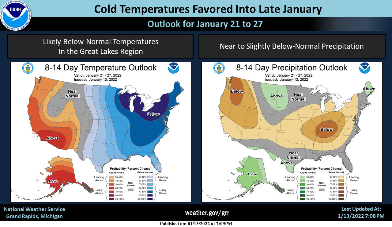
Warm-ups will tend to be brief and cold snaps will often be more prolonged through late January. Occasional snow can also be expected (especially lake-effect snow), but major snowstorms are not the most favored outcome in this pattern.
Forecast Discussion
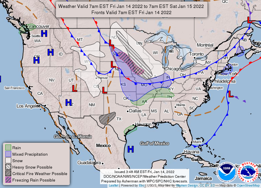
- Small chances for precipitation through Monday

Overall, the weather continues to look relatively benign as compared
to what can happen in mid-January around these latitudes. There will
be multiple chances of precipitation, although none of them look to
be significant at this time.

The only chance of precipitation through Saturday night would be a
few flurries making it to the U.S.-127 corridor from Lake Huron. The
dominating weather feature is the snowstorm out to our West, and
eventually South this weekend. This pattern will allow the low level
flow over Lower Michigan to be from the NE. Moisture will not deep
over the area, but enough of a streamer off of Lake Huron might have
enough strength to reach into our area. This would likely be a
dusting of snow, if that.

There will be another chance of some lake effect for Sunday night
through Monday. The low level flow is expected to swing around to be
from the NNW. 850 mb temps in the negative mid teens C would support
sufficient instability for some lake effect. Additional support for
lake effect will come in the form of an upper short wave that will
be passing through. This will help to raise inversion heights into
Monday. As quick as the short wave and higher inversion heights move
in, they will move out just as quick by Tuesday morning.

- Chances for snow with a system on Tuesday

We continue to watch a system that will move through the region on
Tuesday that could bring some snow to the area. The upper wave and
associated sfc low track look like they have trended a touch further
north over the last 24 hours. This northward trend would bring a
threat of some snow to Central Lower, and not much if anything for
Southern Lower.

- Colder with lake effect chances mid-late next week

There may not be much snow directly with the Tuesday system for most
of the area. There remains good agreement that colder air will drive
south behind the Tuesday system. 850 mb temps will drop to around
-20C, supporting highs likely only in the teens. This will support
lake effect snow chances, especially for Wed and Thu as the upper
jet dives south of the area. This will put us under the more
favorable unstable cold air aloft/cyclonic side of the jet.
What a winter! The CPC shows cold the rest of this month and increasing chances of snow! Bring it on!
WHO KNEW?? InDY
I wonder if this Wednesday and Thursday will be the coldest days of the year. Right around the average time of year… hopefully!
Temperatures falling into the teens this afternoon wow to the wow ….No real warm air in sight …InDY
Yes the pattern is really setting up for tons of cold and snow, yet we are still hearing from some that we have seen hardly any winter weather at all! What a joke!
Where’s the snow?
7.3 inches on the ground in my area you should go outside and enjoy it build a snowstorm…InDY
Highs only around 20 degrees today and tomorrow ohh dont forget Sunday tooo what another perfect Winter fun packed weekend ahead ice fishing sledding snowmobiling great scotty Im losing track woo woo …Indy ..
Looks like the “big snow” forecasted next week has now shifted north of us. We will now be below average snow soon. Very quiet.
Wow you really are clueless!
Lol….Let it snow let it snow let it snow ..InDY
The temperature held in the low 30’s most of last night but now the colder air in filtering in and it is now down to 23 here with cloudy skies. It still looks cold and dry for the foreseeable future. In looking at past years this is kind of a rare pattern with cold with little snow here in January. I am sure it has happened but it is not common. It is more common in February after the lakes froze up more.
Slim
Having lived my entire life in and near the “lake effect zone”, the past several years have been very odd in that the lake effect snow has been almost nonexistent. Other than last weeks event I can’t even remember the last decent lake event we’ve had. Dry and snowless, the new normal?
Just ran to the office. Getting some freezing drizzle now. Temp is now 26. Saw multiple salt trucks on the road, which has been an uncommon sight this winter.