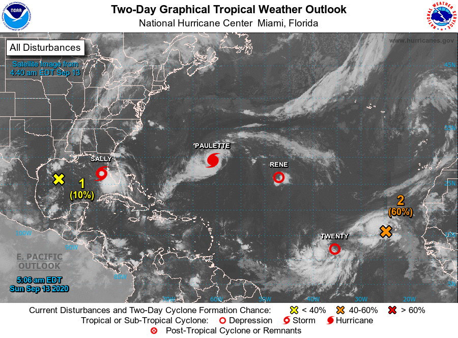
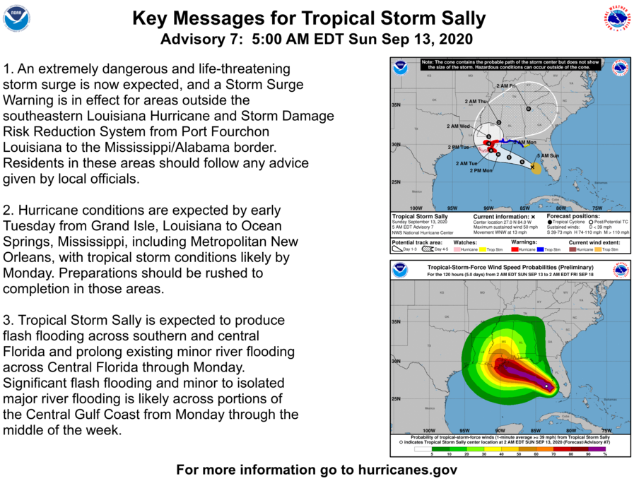
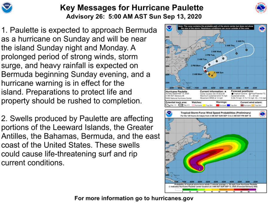
We have had a busy tropical weather season this year with three more named storms in the Atlantic today. TS Sally is expected to make landfall by Monday. Paulette is expected to be well off the eastern seaboard.
[columns] [span6]
[/span6][span6]
[/span6][/columns]
KEY MESSAGES:

1. An extremely dangerous and life-threatening storm surge is now
expected, and a Storm Surge Warning is in effect for areas outside
the southeastern Louisiana Hurricane and Storm Damage Risk Reduction
System from Port Fourchon Louisiana to the Mississippi/Alabama
border. Residents in these areas should follow any advice given by
local officials.

2. Hurricane conditions are expected by early Tuesday from Grand
Isle, Louisiana to Ocean Springs, Mississippi, including
Metropolitan New Orleans, with tropical storm conditions likely by
Monday.  Preparations should be rushed to completion in those areas.

3. Tropical Storm Sally is expected to produce flash flooding across
southern and central Florida and prolong existing minor river
flooding across Central Florida through Monday. Significant flash
flooding and minor to isolated major river flooding is likely across
portions of the Central Gulf Coast from Monday through the middle of
the week.
There are normally fewer than 21 named tropical storms in any calendar year. In the rare years when more than 21 storms are named, the additional storms are given names from the Greek alphabet: Alpha, Beta, Gamma, Delta are used for their names. This will be one of those rare years we may see this happen.
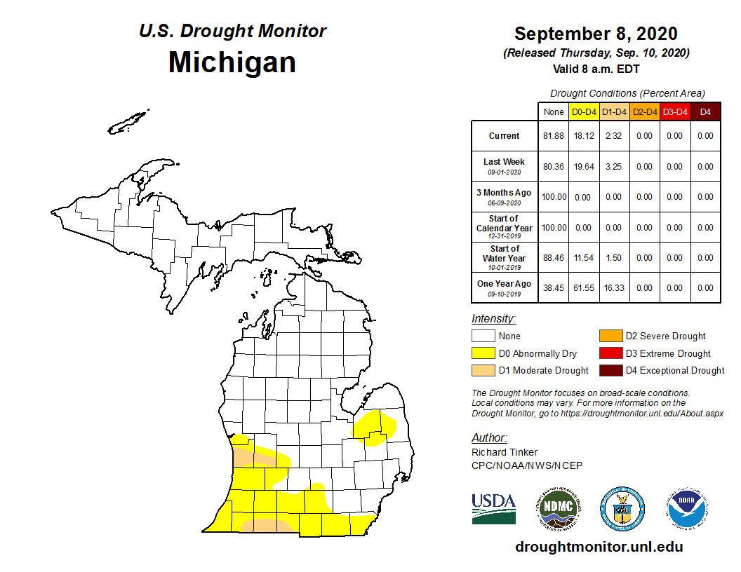
We have had .20 of an inch of rain yesterday and overnight in Otsego and a current temp of 61 at 6 am. This brings our total for the month to 2.69 inches. Below is the current drought conditions for Michigan as of last Thursday.
All the NWS graphics are not available yet this morning – you can find them on the main page here as they become available. I keep farmers hours so I am sometimes up before the NWS graphics are updated which is usually anytime between 4 am and 7 am.
Forecast Discussion:
-- Drying out early this week with pleasant temperatures --

Frontal passage during the middle of the night produced some
brief 15-25 mph wind gusts near and south of I-96. Now under the
thermal trough at 850 mb today with low-level moisture slow to
exit, there may be lingering stratocumulus for much of the day
especially north of I-96 away from Lake Michigan. Breezy west
winds are expected to develop with diurnal mixing also, given the
15 to 20 knot winds in the lowest 3,000 feet.

Temperatures won`t be too far from mid-September normals the next
few days, with a warming trend Tuesday and Wednesday in southwest
flow behind the low level anticyclone. Radiational cooling
tonight and especially Monday night could make a few spots rather
chilly.

One note, given the mostly sunny skies in the forecast Monday and
Tuesday, the HRRR-Smoke is advecting a fairly dense upper- level
smoke plume (from the western US fires) over our region on Monday,
and it is extensive enough to seem able to continue at least
through Tuesday. So skies will likely not be brilliantly blue
then. The smoke isn`t expected to mix down to the surface.

-- Chance of rain Thursday --

Ensembles are split on rain chances for Thursday ahead of a cold
front, with some producing heavy rain swaths and others staying
dry. For now, Tropical Storm Sally (or hurricane as forecast) is
not expected to affect our area, though some mid-level moisture
contribution is possible in solutions that bring us rain.

-- Cooling off next weekend --

The 00Z ECMWF has 850 mb temperatures falling below 0 C over the
weekend, with strong high pressure overhead. Could be frost
potential in some locations if this were to verify.
The below normal temp pattern just keeps rocking! What an incredible stretch!
It is an incredible stretch in the fact that it has lasted almost a week and a half compared to the 3 and a half month stretch of above average we just had before it. We only need roughly 100 more days to just equal that stretch. Incredible.
Here at my house I recorded 0.08″ of rain yesterday. As noted before the way CoCoRaHS likes to keep their reports (from 7 AM to 7 AM) is different from the way the NWS keeps their records of 12 AM to 12 AM. At this time it is clear here with a temperature of 61.
Slim