
We had a few sprinkles overnight and warm temps, it is currently 68° at 4 am. Yesterday’s high/low was 73°/29° in Otsego.
Below is Aprils climate summary from the NWS:
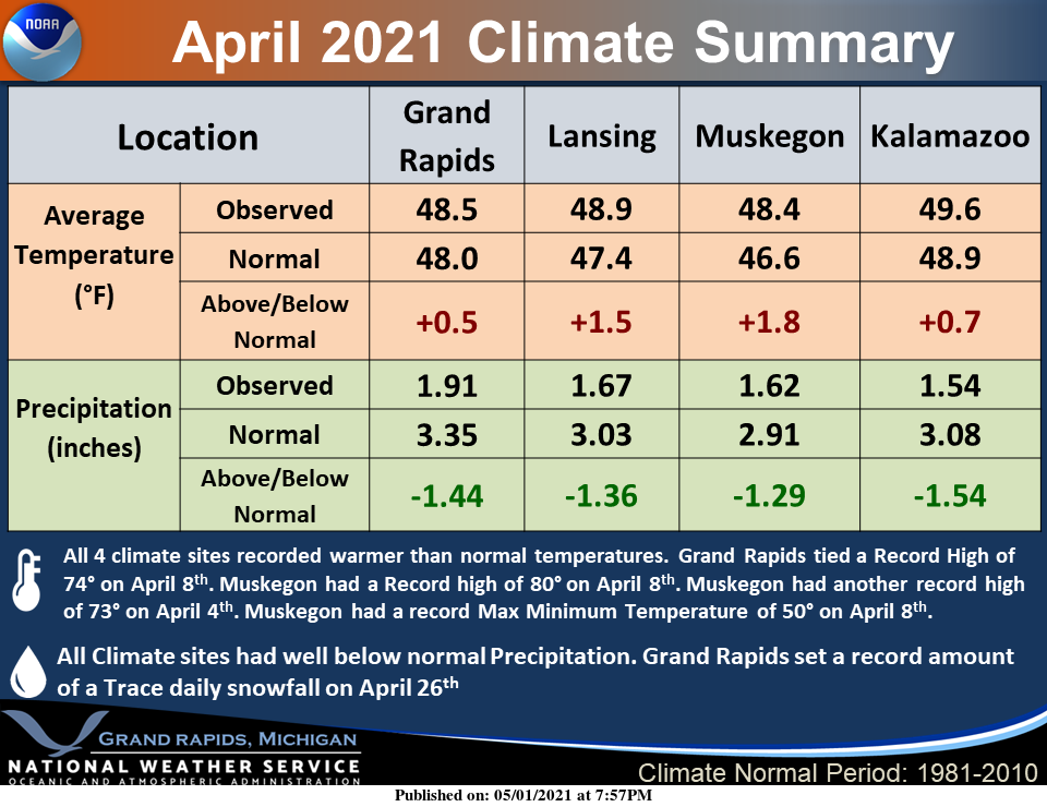
All 4 climate sites recorded warmer than normal temperatures. Grand Rapids tied a Record High of 74° on April 8th. Muskegon had a Record high of 80° on April 8th. Muskegon had another record high of 73° on April 4th. Muskegon had a record Max Minimum Temperature of 50° on April 8th. All Climate sites had below-normal precipitation. Grand Rapids did have a record amount of a Trace of snowfall on April 26th.
While we have been precipitation starved over the past few month I thought it would be a good time to put up the historical tropical storms which have came up into Michigan (this goes back to 1863):
hurricanes michiganForecast Discussion
- Low pressure moves along cold front bringing rain and thunder
  chances into Tuesday

Showers are expected to continue today along a warm/stationary
front aligned across our northern forecast area. Instability
remains elevated and marginal for convection, but given
thermodynamic impetus of latent heat effect courtesy of the dry
wedge under cloud base, even moderate showers can produce
localized wind gusts over 40 mph into this afternoon.

The near surface dryness will begin to moisten up overnight as
southerly flow continues to advect Gulf moisture northward.Highest
POPs and QPF this evening will be across the northern zones where
the moisture transport intersects the front. Eventually, the rain
shield from the southern low makes a run at our southern zones on
Monday but a northern stream trough is amplifying and kicks the
low out to the east,taking the bulk of the rain with it.

We are not quite done yet, as another surface low forms as the
trough axis approaches and brings an area of rain towards southern
Lower Michigan. Ensemble spread is still too great to pin details
on this down well yet.

- Upper troughing and cooler than normal temps after Tuesday with
  frost/freeze potential

Trend to cooler temperatures on Wednesday into the weekend with
frost and freeze potential as Canadian sfc high builds in,
especially after Thursday after a northern stream shortwave moves
through.
Oh man, gonna have to fire up the A/C tonight!! Incredible heat for this early in May!!
Oh yeah!! 82 for the high today!! Nice temps leading into my Texas trip! Beautiful warm spring we’re having!! I love warm springs!!
This is the fourth 80 degree day here this year already. For the record – you can’t tell the difference between 79 and 80.
For sure Mark! Been a tremendous warm spring!
81 degrees here and at the airport. What a cool day we are having?
The latest reading at GRR was 78 with a DP of 58. And yes it still is windy. Here at my house I have a temperature of 80 with a DP of 58.
Slim
Still waiting on grass seed I’m seeing more 30’s for lows coming this week crazzy for the start of May such a cool Spring we are having …INDY
Grass is very hearty. I put down some grass seed a month or so ago – just in the spots where the dog did her business all winter long. It’s coming in nicely now.
Awfully warm out today, looks like the rest of the week will be more refreshing. Definitely still need to adapt to the warmer weather.
Agreed. Feels hot today. I shouldn’t be sweating this much on May2nd.
The last half of April was colder than normal and very windy! Quite a cool pattern!
Yes, the 2nd half of April was colder that average. The first half of April had 10 days with a mean above average and 5 days with a mean below average. In the 2nd half there were only 3 days with a mean above average and 12 days with a mean below average. In a way it was a month of extremes with 7 days more that 10° warmer than average and 5 days more than 10° below average.
Slim
Yep…accidental 48hr warmth, then a cold May.
You got it! Starting Tuesday and lasting multiple days we will be entrenched in a cool trend!
So the Climate Summary had all reporting stations above normal for April, including several record highs around the area. This means that either the Summary is wrong, or the multiple posts every day telling us how cool April was are wrong. I think I’m inclined to believe the Climate Summary.
One of reporting station not listed had a April mean of -0.3 and that was Holland. But the month was close to average at Grand Rapids, Kalamazoo and Holland. Near average is considered less than a degree (+),(-) or (0) of course months right at average are the most rare. For the state of Michigan all other reporting stations were above average for April.
Slim
The overnight low here at my house was a warm 63 and the official overnight low at GRR was a summer like 65. If it stays above 62 at the airport until midnight that 65 would set a new warmest minimum for May 2nd at Grand Rapids. There was just 0.01″ of rain fall here yesterday and overnight as several periods of sprinkles came thru. At this time it is partly cloudy and 66 here and the last reading at GRR was 67.
Slim
Enjoy the one day warm up, because the bottom falls out later this week? Get ready for a well below temp week and beyond! Incredible cool pattern the keeps rolling!