We have a state-wide tornado drill at 1 pm this afternoon. This is part of Severe Weather Awareness Week from March 20 to 26. You may hear the sirens go off in your town or city and broadcast media including NOAA Weather Radio will broadcast test alerts. This is a good time to have a plan in place to know where you will go in case of severe weather.
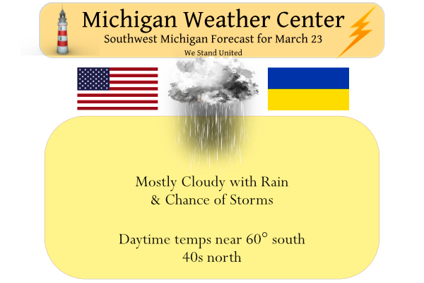
The SPC has us in the slight to marginal risk for storms this afternoon. Thunderstorms will be possible on Wednesday and into Wednesday evening. Some of the storms late in the afternoon and early evening could become strong to severe across far Southern Lower. Damaging winds and large hail will be the main threats.
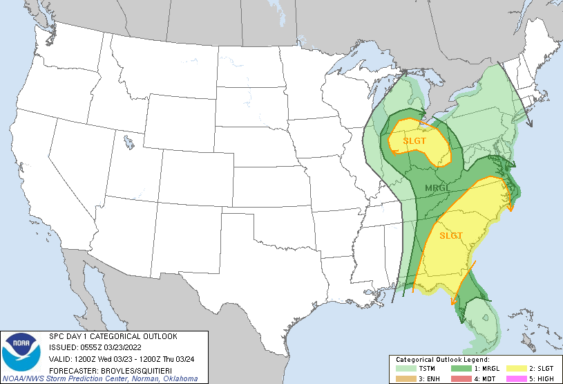
SPC Summary
 ...Ohio Valley/Great Lakes...
   An upper-level low will move across the mid Mississippi today as a
   90 to 110 knot mid-level jet moves northeastward across the
   Tennessee Valley. At the surface, a cold front will advance eastward
   across Ohio and Tennessee Valleys as low-level moisture advection
   continues across the southern and central Appalachians. Surface
   dewpoints are forecast to increase into the lower to mid 50s F in
   much of central and eastern Ohio by midday. Increasing instability
   during the day will result in scattered thunderstorm development
   from Illinois southeastward into southern Indiana and central
   Kentucky. These storms are forecast to move northeastward into
   southern Michigan, Ohio and West Virginia during the afternoon.

   The exit region of the mid-level jet will overspread the Ohio Valley
   today. This will create very strong deep-layer shear making
   conditions favorable for somewhat widely-spaced severe storms. RAP
   forecast soundings at 21Z along the instability axis from western
   West Virginia into central Ohio have MLCAPE peaking at 1500 J/kg,
   and show 0-6 km shear at extreme levels in the 95 to 105 knot range.
   This will make conditions favorable for supercells with large hail.
   A few of the stronger supercells may have tornado potential,
   especially as the storms interact with the western edge of the
   low-level jet during the late afternoon. Wind damage will also be
   possible with the more organized storms during the late afternoon
   and early evening when low-level lapse rates will be steep.
Weather History for SW Michigan
March 20
1976: A tornado outbreak struck from Michigan to Mississippi. In Michigan, two people are killed, one each in Oakland and Macomb Counties.
March 21
1983: Spring starts on a snowy note with record daily snowfall of 6 to 8 inches from Muskegon to Lansing.
2008: A record 6.6 inches of snow fell at Grand Rapids on the first day of Spring. Muskegon had a record 7 inches, while 8 to 14 inches of snow fell south of a line from Holland to Jackson.
March 22
1938: Temperatures soar into the 80s during one of the warmest March days in Lower Michigan. Grand Rapids ties their record high for the month at 82 degrees and Lansing sets a record for the date of 81 degrees.
March 23
1956: A snowstorm drops from 6 to 10 inches across southwest Lower Michigan. Jackson picks up 10 inches of snow and Grand Rapids a record 8.4 inches
March 24
1901: A tornado killed one person and injured four others in Kalamazoo County as it moved from Vicksburg to Scott.
1904: Tornadoes hit Muskegon and Grand Rapids. In Muskegon, five homes were unroofed or torn apart on the lakefront at Harrison Street. In Grand Rapids, ten people were injured as the tornado damaged a church and several barns.
March 25
1954: Heavy rain and high winds occur as a cold front moves through. Grand Rapids measures 2.82 inches of rain for their wettest March day on record. Flooding of streams is widespread and winds gusting over 70 mph cause roof damage and uproot trees.
1974: Grand Rapids falls to one below zero for its latest subzero reading on record.
March 26
1934: A record snowstorm began across southeast Lower Michigan with around a foot of snow falling at Jackson, Lansing and Battle Creek. Snow totals dropped off quickly to the northwest with Grand Rapids getting only about an inch.
1993: Dense fog caused a fatal airplane crash at Ludington. The pilot was trying to land in near-zero visibility and collided with trees and terrain on his second approach to the airport. The pilot was seriously injured and his wife, the only passenger, was killed.
Weather History for SE Michigan
March 20
On March 20, 2012, highs of 82, 84, and 83 were recorded in Detroit, Flint, and Saginaw and respectively. Each temperature tied the warmest March temperatures ever recorded at the time. However, all records would be broken in the coming days. Ultimately March 20, 2012, would be the third warmest March day ever recorded for Detroit and the second warmest for Flint and Saginaw.
Also on March 20, 1976, an F4 tornado moved through West Bloomfield in Oakland County at 7:15 PM. This tornado was responsible for 1 death, 55 injuries, and over $5 million in damage. This is both the strongest and costliest tornado to ever hit Oakland County.
Also on March 20, many snowstorms have hit Southeast Michigan with greater than 6 inches over a large area of the region including in 1967, 1983, 1989, 1992, and 1996. In 1983, the Flint snowfall of 9.6 inches is the tenth heaviest snowstorm in its history.
March 21
On March 21, 2012, high temperatures of 84, 86, and 87 were recorded in Detroit, Flint, and Saginaw respectively. All of these temperatures broke the all-time March records for warmth at each location. Saginaw was particularly impressive, shattering its previous all-time March record of 83 by four degrees. Ultimately, one more record-breaking day in Detroit would relegate this day to be its second warmest March day ever recorded. The records for Flint and Saginaw, however, still stand.
Also on March 21, 2008, a winter storm hit the greater Metro Detroit region. While most of the metro area received 3 to 7 inches of snow, a band of 8 to 10 inches fell from Dexter and the Irish Hills across Saline, Tecumseh, Dundee and into Temperance.
Also on March 21, 1913, powerful winds swept across Southeast Michigan as a strong cold front moved across the state. The wind storm was one of the strongest in the local climate record and caused widespread damage, countless injuries, and several fatalities.
According to the historical record, east winds gusting to around 30 mph during the pre-dawn hours turned to the south, allowing the temperature in Detroit to rise to 57 degrees by 9 a.m. With the passage of the cold front, temperatures fell precipitously through the day, reaching a low of 23 degrees by midnight. As the cold air first began spilling into the area, winds initially turned southwesterly and began gusting to over 60 mph between 9 a.m. and 10 a.m. The average wind speed during the following hour increased to 71 mph with a peak gust of nearly 80 mph. Shortly thereafter, at 11:15 a.m., a peak wind gust of 86 mph was recorded. Altogether, winds gusted in excess of 70 mph for approximately 3 hours while gusts in excess of 60 mph continued for around 6 hours.
Damage was significant, widespread, and conservatively estimated at $500,000 (equivalent to $11,500,000 in 2012 dollars after adjusting for inflation). Buildings were razed, roofs and chimneys were destroyed, and trees were broken and uprooted. In addition, vehicles were overturned and there were accounts of a delivery wagon having been blown through the window of a restaurant on Lafayette Boulevard. In addition to several fatalities, one of which included a Grand Trunk watchman who was blown in front of a moving train, injuries to pedestrians were numerous and included arm, leg, and skull fractures. The strong winds also caused the Detroit River level to fall so low that the water intakes for manufacturing plants were cut off, resulting in their closure. On the Canadian side, thirteen freight train cars were derailed by large waves.
March 22
On March 22, 2012, an unprecedented spring heatwave, and quite possibly the most anomalous weather event in over 130 years of record-keeping in Michigan, came to a close. The high temperature of 86 was the warmest March temperature ever in Detroit, beating by two degrees the record of 84 degrees set the day before. Highs of 84 and 75 in Flint and Saginaw fell short of the all-time March records set the day before. However, the 84 degree high in Flint still tied for the second warmest March temperature on record (Flint also reached 84 degrees on March 20, 2012, and March 22, 1938).
Altogether, SE Michigan shattered all significant records for March warmth. Detroit set 6 records in 8 days, including tying or breaking the monthly record twice. Flint set 8 records in 9 days, including tying or breaking the monthly record three times. Saginaw set 6 records in 8 days, which also included tying or breaking the monthly record two times.
The heatwave also included 10 consecutive days (March 14-23) of 70 degrees or higher in Detroit. This has never happened in March. In fact, it has never even happened in April. The closest competition is a span of 9 days late in the month of April over 125 years ago, in 1886.
Also on March 22, 1938, the daytime temperature soared to 82 degrees in Saginaw county, which ties for the third-highest maximum temperature recorded in Saginaw in the month of March.
March 23
On March 23, 1888, the daily records for both Lowest Maximum Daytime temperature and Overnight Low temperature were set at 18 and 2 degrees, respectively in Detroit.
Also on March 23, 2011, a snowstorm started on the 22nd and continued into the morning hours as it hit the Flint, Saginaw and Thumb regions. 4 to 8 inches of heavy, wet snow fell. For areas along the I-69 corridor, a tenth or two of ice fell on top of the snow. The combination of snow and ice lead to over 10,000 customers without power.
March 24
On March 24, 1965, Flint set a record low with -7. Three days later in 1965 Flint fell to -2. These two dates are the latest in a year that Flint has recorded below zero temperatures.
March 25
On March 25, 1945, record high temperatures for the day were set simultaneously in Detroit (78 degrees), Flint (79 degrees), and Saginaw (80 degrees)!
Just two years later on March 25, 1947, a snowstorm dumped 13.3 inches on Saginaw. This was the 11th heaviest snowstorm in Saginaw history.
March 26
On March 26, 1968, an F2 tornado hit Monroe County causing approximately $250,000 in property damage.
Also on March 26, 2007, the temperature soared to 81 degrees in Detroit breaking a record for the date. Flint and Saginaw both hit 76 degrees. On the next day, Detroit once again hit 81 degrees to set a record. Detroit has only reached 80 degrees or higher 12 times in the month of March, twice in March 2007.
Forecast Discussion
- Potential for thunderstorms this afternoon/evening -

Our primary shorter term fcst challenge is to assess convective
and svr wx potential for later today into tonight. Overall short
range guidance trends the past 24 hrs show better potential for
some convection later today. This potential will develop as the
sfc low moves to southern Lake MI by 00Z with a warm front extending
ese from the low across far southern MI.

Convective potential will occur due to ample moisture in
conjunction with lift from the frontal boundary and increasing
instability mainly near to south of the warm front. 00Z HREF
guidance suggests most unstable CAPE values could reach 750-1000
j/kg in this area. 0-6km bulk shear values also look very favorable
this aftn before diminishing quickly this evening.

The overall svr wx potential is fairly low mainly due to
relatively weak instability. Nevertheless a few strong to
svr storms are possible near to south of I-96 from around 19Z-01Z
when instability will be maximized. This notion is supported by
the HREF composite Z >40 dBZ ensemble guidance for convective
potential.

Localized damaging wind gusts are the main threat given favorable
kinematics. Forecast soundings in the warm sector by late aftn
show steep low level lapse rates/strong speed shear w/height.
There is also potential for an isolated weak tornado near to south
of the warm front where 0-1 SRH values will be greatly enhanced
with favorable shear/low lcl heights. Effective shear looks most
favorable over our far se fcst area based on latest sref guidance.

Otherwise we expect occasional showers today and tonight. Some
rain showers will linger Thursday as well on the back side of the
departing system with a transition to a light wintry mix of pcpn
later in the day into Thursday evening as caa continues.

- Colder and unsettled weather through early next week -

The wx will turn progressively colder this weekend into early next
week. A few mixed light rain/snow showers will linger Friday
followed by a better chance for pcpn Friday night as a northern
stream system moves in from the nw. High temps by Sun/Mon will
likely only reach the 30s with a brief period of dry wx then as a
sfc ridge builds in.  A clipper system will bring potential for
snow or mixed pcpn by Tue.
Nevee hit 55 in GR today the forecast was a little off I see only 43 out in my area ….Cool and wet …Indy
Get ready for mid winter cold this weekend! Wow, just wow! What a cold stretch!
Nice to see the grass beginning to green up a little. Just today it has started to green up. Spring is not here for good as we will be returning to colder temps and probably some snow. This is no shocker though for those that know Michigan weather. Warmer spring temps are on hold for a little bit.
Looking good!
http://wxcaster.com/gis-gfs-snow-overlays.php?STATIONID=GRR
Thundering here….
I am sure that there are people that have been out playing golf heck there may have been people that have taken a dip in Lake Michigan already but here is the best information as to when Golf is even open in Michigan. “When can you start golfing in Michigan? Official Michigan golf season is April 1 – Oct. 31. In the event of unseasonably warm weather in the spring or fall, the USGA now allows state golf associations to change the start and end of their official posting season as needed.” I am not sure what their definition of… Read more »
I saw more golfers out today! You were able to golf 10 months of the year in Southern Michigan this year.
Our course is not open yet. The grounds crew returned last week and they’ve been working since. Forest Akers (MSU’s course) is open.
Of course it is not open yet! Golf course conditions in March are horrendous! Has anyone seen the forecast for the rest of this month! Absolutely no reason to be open right now!
The National Weather Service has postponed its radio test in the statewide tornado drill scheduled for today.
Slim
But, if I wanted to, I could take the quick 3 hour drive to Chicago where temps are gonna be in the 50’s on Friday and play 18! But, I’m not completely obsessed with golf and I’m not trying to prove any points, so, I think I’ll stick with my spring cleaning plan this weekend!
Get ready for a string of below normal temps and a very cold weekend! Andy and mookie will say theses are nice Spring days and good golf weather! How wrong can they be? And yes we will be seeing more snow this season! Get ready!
Well this is a good thing, I have some spring cleaning to do in the garage this weekend and a couple of indoor projects I need to get done. I don’t have time for golf this weekend anyway! Back into the 50’s a week from Saturday, so that will be fantastic for golf!!! Who knew?!??!
Lol a week form Saturday! So another 10 days of below normal temps! Enjoy!
I am enjoying it! No snow makes me very happy!!
As predicted, yesterday’s “cool” day was yet another above average temp day. Today should be our 10th straight warm day.
How is that possible?? The cold weather crazies said we are stuck in a cold weather pattern where we would be pummeled with snow??
I picked up 0.6” of rain last night at my house. It’s currently a chilly 42 and cloudy at my house
I really need to get a rain gauge so I can report totals at my house. And also learn how to measure rain properly… anyone have tips on how to measure rain? Location in yard, how often to empty, etc?
I recorded 0.24″ of rain from yesterday late afternoon to 7AM this morning. The official high yesterday at Grand Rapids was 46. The overnight low in MBY was 38 and at this time it is cloudy and 42. With a high of 85 this was the last really warm day of the heat wave of March 2012. In that March heat wave there were 9 days in a row with highs in the 70’s and 80’s ranging from 74 to 87. And in total there were 15 days in a row with departures of +15° or more with 5 of… Read more »
Is MBY an acronym for “my back yard”? 🤔 Never heard that one before!
yes
Slim
What a storm last night!! Now we’re getting a nice warm spring morning rain!
What could be better?!
Don’t know how much rain we got, but it pounded the windows most of the night.
Looks like the official rain fall for Lansing was around 0.44″ so far for this event.
Slim
Thanks Slim.