We ended up with 1.53 inches of rain from the wet system which passed through on Monday thankfully we have a sunny day in store to start to dry things out a bit. We have had 5.29 inches for the month and 7.45 inches for the fall season. Yesterday’s high temp was 47.8° and the low was 42.8°.
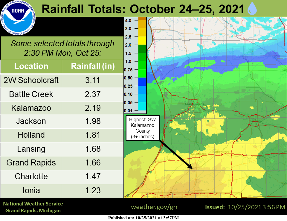
That was quite a soak (for many)! With the rain now ending, here’s a plot of rainfall totals through 2:30 PM, using a blend of gauge measurements and radar estimates. We’ve also included a table of some measured amounts. 2”+ was common along the I-94 corridor, with 1.5–2.0” along I-96. Some rivers and streams have risen markedly, but no flooding is expected. Meanwhile, some of our northern areas didn’t see any measurable rain!
Forecast Discussion
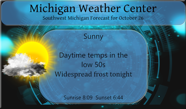
- Dry for most locations through Wednesday night

A few early morning showers are possible near Ludington as a shallow
lake effect setup will be in place.  Other than that, we will
feature dry conditions through Wednesday night as a mid to
upper level ridge builds in from the west.  Subsidence associated
with this feature will support deep drying of the atmosphere.
Abundant sunshine will prevail today as a result.  Seasonably cool
max temperatures in the low to mid 50s are predicted.  Good
radiational cooling is expected tonight as the winds will be light
and the atmosphere dry.  Cooler than normal lows are predicted with
low to mid 30s likely and even a few 20s possible.  Low level
moisture is shown by the models to increase from east to west
on Wednesday.  We will trend the forecast towards more cloud cover as
a result.  These clouds may also hold back the max temperatures on
Wednesday.

- Rain moves in later Thursday into Thursday night

The next wave of low pressure approaches from the west Thursday.
This system is projected to remain south of the area with many
of the models tracking it up the OH Valley.  The system is shown to
feature a closed mid level low that is projected to slowly
as it moves into the Central Appalachians.  Here in MI, we are
expected to see a band of rain lifting in from the south later
Thursday into Thursday night.  Mid level Fgen, trowal and some upper
level divergence will support wet conditions for much of the CWA
persisting into Friday. A diminishing trend to the rain is predicted
for later Friday into Friday evening as the storm system pulls away.
While most of the area will see rain, overall QPF values are not
expected to be significant with many locations likely to see a half
inch or less. Highest amounts for Southern Lower MI.

- Cold front pushes in for later Sunday into Sunday night

The models are showing a cold front pushing in from the northwest
later Sunday into Sunday night as a surface low deepens near Southern
Hudson Bay.  The next cold airmass looks significant as cold air
advection is shown through the Canadian Prairies. The 00z GFS
and High Res Euro are showing a surface wave developing upstream
along the front for Monday.  They then track this wave into parts
of the CWA for Monday night or Tuesday some precipitation.
There is a big drop off in the average temperatures over the next 6 days. The average H/L starts out at 56.1/39.1 today and by Sunday it drops to 54.0/37.5. The overnight low here at my house was 34 and there was some frost this AM the official overnight low at GRR was 37. The grass is growing by the day and I will have to cut it once again. Not sure how many more times I grass will have to be cut this fall yet. And most of the leaves are still on the trees this is one of… Read more »
The first trees behind our house have finally changed over, but 80 to 90% of them are still green. And the grass, this is the fastest it’s grown all year. With the drought conditions this Spring, and even as recently as just a few weeks ago in September, I’m mowing more now than I have all year. And next week is November.
It is awesome to see the sun this morning. It is so bright.
Less than a week to go in October and it’s still pretty green. No doubt, October will go down as yet another warm month in our multi-year warm pattern.
Until just the past few days this October was on track to be the warmest on record in many locations. With the recent cool down that will not happen but this October should end up well above average.
Slim