
We have hit our first morning low in the 30s for the season here in the valley of Otsego. We have 39.7° at 6 am. Yesterday was a cool 55° and the morning low was 45°.
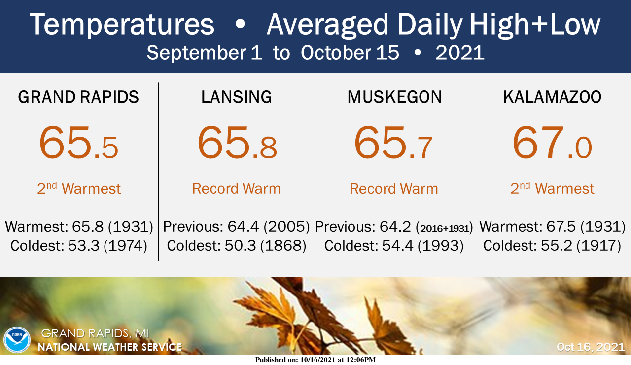
We are halfway through climatological fall (which starts on September 1) and compared to previous years, this 45-day period has averaged out to be the warmest or second-warmest on record. Afternoon high temperatures have been running Top 10 warmest, but more significantly, overnight low temperatures have been running at or near-record warmth. Since mid-summer, overnight temperatures have not dropped any colder than the mid-40s yet, which smashes the previous records at our long-term stations by several degrees. By this point in the year, a little over half of all autumns on the books have seen temperatures 32 degrees or colder.
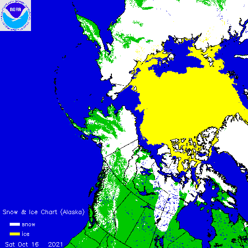
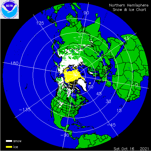
We have snow accumulations creeping southward in Canada and we have snow in the Rockies – below are the latest graphics from the snow and ice archive. Still a ways to go before we are threatened with the white stuff – I am still thinking sometime in November we will see the ‘flip’ to colder air and snow.
[columns] [span6]
[/span6][span6]
[/span6][/columns]
We are looking at a good portion of the week to be above normal temp wise with lots of sun – let’s hope the leaves on the trees change and fall before our first snowfall. I am not looking forward to leaf removal even though I mulch most of them with the lawn tractor.
Forecast Discussion
- Dry weather expected through Tuesday

Dry weather is expected today through Tuesday and likely through
Tuesday night as well. High pressure will slide east through the
area both at the surface and aloft which will eliminate any
chances for precipitation. BUFKIT overviews are very dry through
the depth of the atmosphere today through Tuesday. 500mb heights
and 850mb temperatures will be on the rise, peaking Tuesday night
into Wednesday. So, a warming trend will be noted with highs
making it back into the 60s today, warming to near 70 for Tuesday
and Wednesday.

- Chances for rain increase mid week

Our only real solid chance at precipitation in the 7 day forecast
will come mid week as an upper shortwave trough and its associated
surface low move in from the west. A surface low will slide across
the plains states Tuesday into Tuesday night and take aim on the
Great Lakes for Wednesday night into Thursday. Best chances for
rain showers in our area are definitely those two forecast
periods. Moisture is not overly deep, but sufficient for us to see
some rain. It has been quite wet of late, so the 3 dry days
(Sun-Tue) will be welcomed. Precipitation amounts at this point
look to range from a tenth of an inch or less towards I-94 and a
quarter to a half inch up towards US-10. Nothing heavy for sure
and hydro concerns are not expected.

- Upper troughing to bring cooler temps and showers late week

Upper troughing will linger behind the mid week wave. A
reinforcing shortwave digs into the Great Lakes trough Friday
night which will bring cooler air into the region. The GFS
actually has below Zero C temperatures at 850mb from Thursday
night through Saturday night. We currently have highs in the 50s
late in the work week and into Saturday. The trend may be to nudge
these highs even down into the 40s given the 850mb temps. As for
precipitation we have isolated pops (20 pct) in the forecast for
now. This looks fine given surface ridging in place. Could see
some diurnally driven showers in the afternoon and evening. Also,
there are hints in the models of some lake effect rain showers.
Too early to tell exactly what direction the steering flow will be
over the lake. Currently the flow is NNW which would keep any lake
effect precipitation close to the lakeshore.
It was a beautiful day today outside. I actually opened some windows to air out the house some. I have really enjoyed the warmer Fall so far and look forward to seeing all the colored leaves. It is one of my favorite seasons.
Looks and feels a lot more like mid September today rather than mid October with the bright blues skies and everything still green. And wow, warmest first half of Fall ever!
The overnight low here at my house was 39.9 and of course that is the coldest low so far this fall season. The official overnight low so far at GRR is 44. This latest date for that 44 low the old record was on October 8th 2016 and while not official the low here at my house of 39.9 (40) is the 2nd latest for that to happen but will update that when GRR officially reaches 40. At this time it is clear here and 41.
Slim
We ended up at 38.5