We managed .03 of an inch of rain yesterday morning, the high temp was 77°, and the low was 61°. We will continue this pleasant stretch of weather right on through the weekend. Our next chance of rain comes Monday.
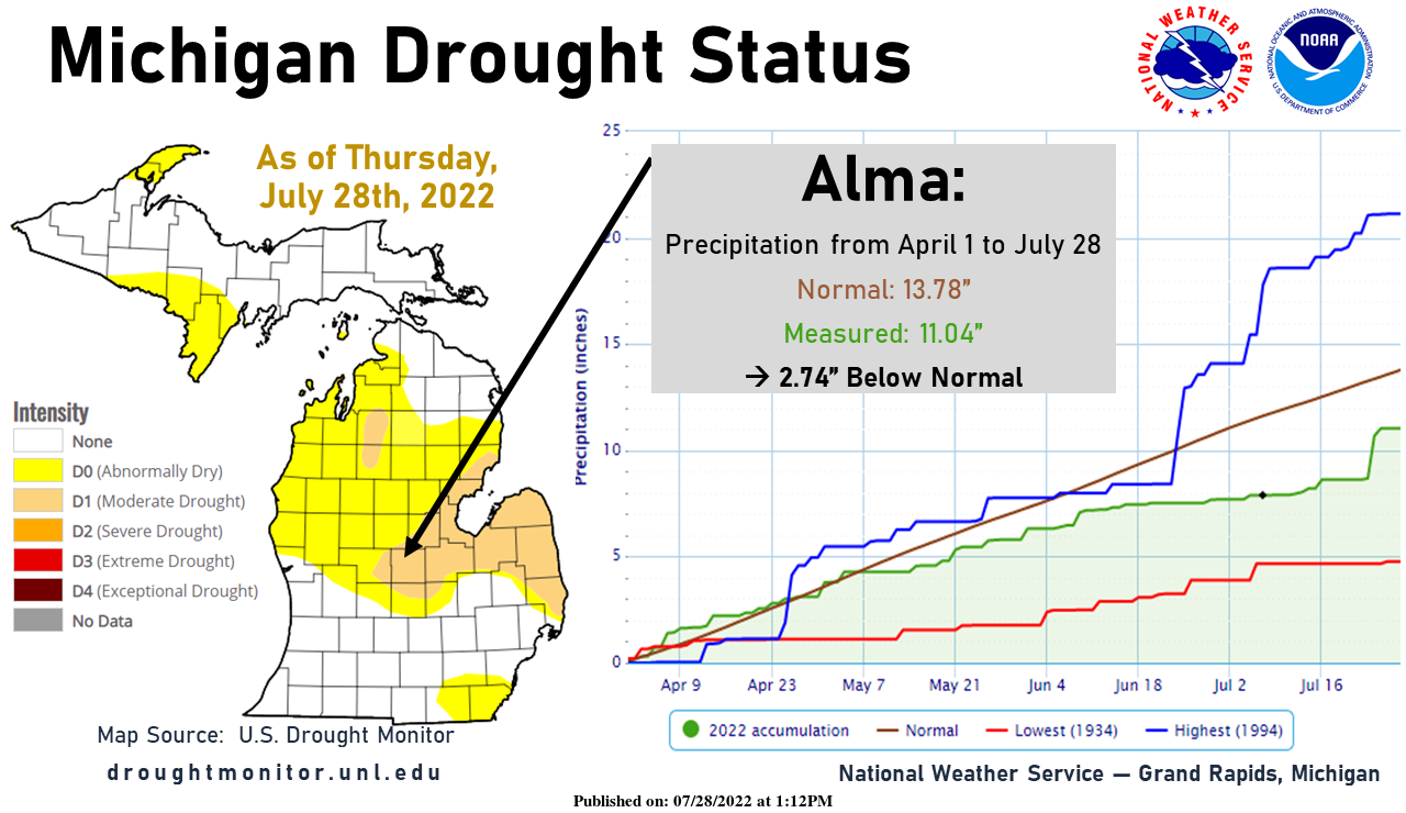
Recent rain has helped ease dry conditions south of I-96. However much of Lower Michigan, especially the thumb, remains abnormally dry. Moderate drought conditions continue to develop in central Lower Michigan. In Alma, for example, the total precip since April 1 is now 2.74” below normal.
Forecast Discussion
-- Mainly dry through Sunday --

There looks to be another nice stretch of weather for Lower Michigan
from today, right on through the upcoming weekend.

Rain chances are not zero today, but we expect dry conditions to
dominate. This is because we do have a fairly potent short wave that
will be coming into the region from the NW this afternoon. Forecast
soundings indicate that a combination of a lack of cold enough air
aloft, and low moisture in the low levels will keep cloud depths
fairly shallow today.

If there were a shower to develop over the area today, it looks like
it would be over the SE corner of the area. This is where less of an
influence off of Lake Michigan would be felt, and where the short
wave will be focused during peak heating. A silent 10 pct chc seems
appropriate for this scenario.

Once this short wave moves through, rain chances for the remainder
of the weekend will be down around zero. This is because we will see
short wave ridging aloft and a nice sfc ridge in control of the
weather. There will be really nothing to trigger any rain, and
really no moisture to work with. Temperatures stay mild with the NW
flow aloft keeping the hot weather to our South and West as it has
been much of the summer.

-- Chances for rain Monday and warming up --

We will see rain chances increase a bit then centered around the
daylight hours on Monday. Rain chances do not look great at this
time for most of the area. The timing of the front coming through
during peak heating would be favorable for better chances of rain.
However, it looks like right now that a short wave would come
through around the morning hours. This means that there will be
subsidence settling in during the afternoon, limiting rain chances.
Also, the best heat and instability will stay south of the state.

The low level jet that will support showers and storms to our west
Sun night will dissipate by the time it would move through here.
Then, the next developing low level jet would ramp up Mon evening,
after it would have moved through here already.

We will see a brief cool down behind the Monday front, hardly
noticeable on Tuesday. The cooler air behind the Monday front will
just give the area a glancing blow Monday night and early Tuesday.
850 mb temperatures will be on the increase again Tuesday afternoon,
reaching 17-20C by 00z Wednesday.

-- Best chance for rain late Wednesday --

Wednesday looks to be a hot day, before some showers and storms
would move in later in the day. We are looking at SW flow bringing
in 850 mb temperatures of 23C or so by 18z Wed. These temperatures
aloft would easily support highs in the 90s.

The full heating potential may be limited just a bit, as a cold
front will approach later in the day. Forecast soundings indicate
that we would likely be capped much of the day with the warm mid
level temperatures in place. Rain chances do look promising however
as upper heights will drop a bit late with the approach of a short
wave. Ingredients are looking somewhat favorable for showers and
storms to be likely. Depending on the details, severe weather would
be in the cards also with the instability, lowering heights, and
decent mid level winds in place to help shear.

We will see a temporary cool down from the heat on Wednesday, before
things warm up again toward next weekend. We will get back into the
NW flow aloft for a day or two before the upper ridge strengthens
and builds over the region. Right now the models are dry. There are
some clues though that we could see a round or two of storms around
the periphery of the ridge/hot dome, as the ridge is building toward
the area.
Get ready – the next 2 nights lows in the 50’s! The below normal temps just keep rocking! Incredible!
From the afternoon discussion:
“The heat of next week is probably the biggest story of the next 7
days. 850mb temperatures over Grand Rapids increase to +25C in the
GFS and +24C in the ECWMF. Those values are significant and do not
happen in most summers.”
“ highs on Wednesday and Thursday will
soar well into the 90s.”
“temperatures mid week into next weekend are going to be hot. The heat will be prolonged.”
What a week! Another of many below normal temp days! Incredible summer so far! No heat waves and plenty of near normal temps! Wow, just wow!
I know that there has been some talk as to how warm this summer has been, but the truth is as of today it has mostly been warner than average, but for most areas not by that much. In fact from today NWS discussion says a lot of this summer. “TEMPERATURES STAY MILD WITH THE NW FLOW ALOFT KEEPING THE HOT WEATHER TO OUR SOUTH AND WEST AS IT HAS BEEN MUCH OF THE SUMMER.” Here is a list of the departures from average means for June and July. At Grand Rapids the departures for June and July +0.3. At… Read more »
SLIM Sofar this Summer has been easy going compared to Summers past in my hood no long drown out heat waves or high humidity for days in a roll now as we get into August I must say Summers last gasp in on have a nice weekend …. INDY
This has been a great summer. Not to hot and not to cool. This upcoming heat wave I suppose could be the hottest part of our summer.
Agreed. Other than being a bit on the dry side, this has been a great summer. So much sunshine.
Its really amazing how much sunnier Lansing has been than Grand Rapids this year so far. You have (I believe) over double as many clear days as us
Yes lots more sunshine over this way. Overall there is more sunshine over here even in the winter. Don’t get as much lake influence. We had more clouds when I lived west of 131. In the winter it can be heavy snow where I used to live and sunny where I am now. I personally miss the lake effect snow bands. Takes a really strong wind to blow them over here.
Yesterday was yet another very nice summer day with the official H/L at Grand Rapids of 79/63. There was a trace of rain fall yesterday morning. But there also was 65% of possible sunshine. So far this morning the official overnight low at GRR has been 61 but here in MBY the low was a cooler 57. And with clear skies it is now 58 here. For today the record high of 103 was set in 1916 and the record low of 47 was set in 1971. Today and into the weekend it looks to be mostly dry and once… Read more »
So just to clarify – it was another below normal temp summer day! Wow!