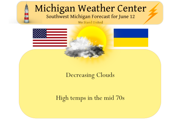
Yesterday’s high in Otsego was 75° and the low 51° – we had a trace of rain overnight.
We will begin to see the heat and humidity increase on Monday after a pleasant day today. The SPC update now has SW and southern Michigan in the slight risk area for severe weather.
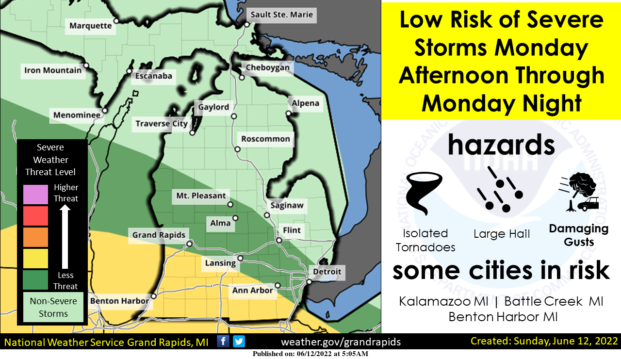
One or more rounds of thunderstorms will be possible Monday afternoon into Monday night. Damaging winds appear to be the main severe weather risk. Frequent lightning and locally very heavy rainfall will also be possible. Stay tuned for tomorrow’s post concerning this severe weather risk.
SPC Outlook for Monday
 ...Upper Midwest into the Great Lakes and Ohio Valley...
   Thunderstorms may be ongoing at the start of the period Monday
   morning across parts of the Midwest (IA/MN and vicinity). This
   activity could pose an isolated severe hail/wind threat as it moves
   eastward Monday morning. There may be an MCV associated with this
   morning convection, and some guidance also shows a corresponding
   mid-level vorticity maximum and enhancement to the mid-level winds.
   Although details in convective evolution remain unclear Monday
   afternoon, there is increasing concern that redevelopment of intense
   thunderstorms could occur with the MCV across parts of southern
   WI/northern IL into southern Lower MI, IN, and OH. Strong to extreme
   instability (MLCAPE 3000-5500+ J/kg) will likely develop along/south
   of a warm front across these areas. Low to mid 70s surface
   dewpoints, strong diurnal heating, and steep mid-level lapse rates
   will all contribute to this large reservoir of buoyancy. 35-45+ kt
   of deep-layer shear should also be present with the enhanced
   mid-level west-northwesterly flow on the northeastern periphery of
   the upper ridge.

   This volatile environment will support significant severe potential
   with any thunderstorms that can form along/south of the warm front.
   At this point, there is still a substantial amount of uncertainty
   with where/if thunderstorms redevelop by Monday afternoon. Both
   global and convection-allowing model guidance show large variability
   in possible solutions, which range from little to no surface-based
   convective redevelopment, to an intense, bowing MCS sweeping
   southeastward in a narrow corridor across parts of the Midwest into
   the OH Valley through Monday evening. Given these uncertainties,
   have opted to include greater (15%) severe wind probabilities and
   add a significant severe wind area where confidence in an MCS
   occurring is somewhat better. Isolated large hail may occur with any
   embedded supercell. A few tornadoes also appear possible, as
   low-level shear will be maximized along and just south of the warm
   front.

   If confidence in the MCS scenario occurring increases, then even
   greater severe probabilities would likely be needed owing to the
   very favorable thermodynamic environment. The eastern/southern
   extent of the severe threat is also uncertain, so have expanded the
   Marginal Risk across the OH Valley into the central Appalachians to
   account for a broad range of possible tracks to the MCS before it
   eventually weakens Monday night.
Forecast Discussion
--Strong line of storms looking more likely South for late Monday--

The forecast shower/storm event last evening and this morning has
drastically underachieved for the area. It seems that we were in
between the better forcing with the expected short wave and
associated weak low level jet going further south, and better
forcing with cyclonic flow aloft over far Northern Michigan. There
were a few showers, but not near the coverage we had been expecting.

The chance of rain has not ended yet, and will linger through a
decent part of the day. The cold front is up toward Pentwater early
this morning, and will be sinking south gradually through today. The
further SE you go today, the better the chance of a shower and even
isolated storm there is ahead of the front. Instability is really
limited, to only a couple hundred J/kg ahead of the front.

The cold front sinking south will eventually become important by
later Monday for the round of storms that will be moving through the
region. The cold front will approach the Ohio River by later
tonight, and will stall out. Then, it will begin to move back north
as a warm front as the ridge builds, and as a short wave/MCV will
help to lift it back north a bit.

The models are all latching on to a potential stronger line of
storms coming through later Monday and Monday evening. There are
still a bit of differences/range of solutions with regards to
track/timing, but we believe they are honing in on the most likely
outcome. A short wave/MCV is expected to ride over the upper ridge
and the drop ESE along the upper flow. This wave will be riding
along a stronger instability gradient with strong to extreme
instability just south of the front as the warm and moist air
builds. It will also be helped by diurnal instability.

There are solutions ranging from the MCS riding through Nrn Lower
(not likely), to the line moving just south of the area. The middle
of the road solution is that of which the Euro has been quite
consistent in showing the southern third of our area to far Nrn
Indiana getting hit by this line. We like this middle ground, and
the SPC does also with the new Day 2 outlook highlighting this.

This line will have the potential for some strong winds as it will
likely have an associated enhanced speed max with it that will help
produce strong effective deep layer shear and band of winds.

--Heat still on track for mid week--

We continue to expect that the heat will arrive across Lower
Michigan on Tuesday, and last through Wednesday. The expected MCS on
Monday will likely keep the hot air to our south a bit longer,
through Monday night as the cold pool will likely reinforce the
front to our south. Then on Tuesday, the upper ridge will build, and
help to drive the front NE through the area, along with the front
"mixing" north as the shallow cooler air mixes out. Once this moves
in, the atmosphere should be capped, and we will warm up into the
90s.

Heat indices will become a problem also as the hot air arrives. This
is because dew points are forecast to increase to around 70 F. This
should push heat indices to around 100 F or so. Right now, it looks
like Heat Advisory criteria is the most likely scenario. With it
still being a couple of days out, it is a little early for an
advisory, so we will continue to message it in social media and
partner messages. Wednesday should be similar in nature.

We will see a cold front arrive later Wednesday night/early Thursday
morning. We are seeing a trend that rain looks like it will be
scarce for the area. That is because much of the synoptic forcing
aside from the front will be staying to our NNW with the sfc wave
and low level jet. Also, the overnight timing is not good for firing
sfc based convection.

--Cooler and dry for much of late next week/next weekend--

We will see temps cool off a bit for Thursday as 850 mb temps drop
from 22-23C to around 16 to 17C. This would support highs still in
the 80s. It will take a secondary front moving through Thursday
night before we see a noticeable difference in temps and moisture
for Friday. This second front looks like it will come through dry
also. This will bring a Canadian sfc high into the region, that will
funnel much cooler air in from the NE. The ridge should sit and
protect us through much of Sunday, while keeping temps cool.
Another gorgeous day. 82 with lots of sun.
Just watched two local TV mets. Both said that it appears the worst of the action tomorrow with be south of us. I’d be happy with some rain.
The record high of 92 Wednesday should be shattered. One said 96 and the other said 98. Either way, the heat index will be triple digits. Six days in the 80s and 4 days in the 90s in the 10-day forecast. Hello summer!
Perfect weather day for this time of year! Out pool side most of the afternoon! Incredible, wow just wow!
Im thinking the possibility of severe weather will be the big story if we get it around west Michigan this week it could be very bad in some spots also when the heat arrives head to Lake Michigan its running well below average for this time of year with water temperatures because of the on going cold we have had since October.. Just a tip if you want to spare the heat I probably will be hanging out there if im not tracking severe weather…INDY
Another upcoming heat wave and it’s been the same song and dance from WOOD. A few days ago it was only one 90 and then back down to low to mid 70’s Thursday and Friday. Now it’s 91 and 92 and 85 Thursday and 78 Friday.
When was the last time we had a heatwave this year?? Did I miss something???? INDY
Yes you did. Lots of record highs.
Lol… okay … INDY
No heat waves yet this year and the one this week is a whopping 2 days! What a joke!
Just had a memory pop up on my Facebook of the Half Dollar size hail I intercepted along I-69 near Perry. This storm dropped baseball size hail in Ovid. I drove through Ovid when the storm passed and the roads were coated in leaves from the hail knocking them off. That was a fun storm chase day.
Wow what another great morning! I just grabbed a coffee and went for a walk on campus.
The heat for Wednesday is looking pretty intense. The iPhone weather app has a high on 97 and dew point of 70… with sunshine that is going to be an extremely hot day. Looks like we “cool off” back into the 80s (still average to above-average), but no cold air anywhere in sight.
Well it in now mid June and soon will be late June. I would really hope that there would not be any mention of “cold” No matter how warm/hot it becomes this week after the cool weather we have had for the past 12 days it will feel very hot. The last time it reached 97 or better at Grand Rapids was in 2012.
Slim
My app says 98 at my house. Not sure if that’s to high or not, but regardless if it’s 93 or 98 still feels the same.
Yeahh Im thinking huge Derachio coming tomorrow afternoon for parts of west Michigan something we have to watch very closely by this afternoon all of west Michigan will be in the slight risk area ..INDY
We will have to see how things look tomorrow morning.
Slim
Interesting the NWS in Chicago mentions the term Derecho in their discussion but the threat is highly conditional if the storms materialize and mature and can break the Cap in place.
We shall see how and if that plays out.
Slim
The track of the storms for tomorrow need to be watched. Based on the NWS and SPC the threat area looks to be Southern MI and Northern IN. I see Bill is watching these storms closely he did a write up on his blog. NWS Northern Indiana is saying CAPE values of 5,000-6,000 which is extremely high. There is a Significant wind hatched area for southern MI into Indiana and 5% tornado. If models come into better agreement and upgrade to Enhanced seems pretty likely, whether that is in Michigan or Indiana we shall see.
On a side note it dropped down to the mid 30’s this morning in the Marquette area for a cold mid June mornign.
Slim
The official H/L yesterday at Grand Rapids was 75/55 there was a trace of rain fall. (just a few sprinkles here at my house) and GR reported 48% of possible sunshine. For today the average H/L is 79/58 the record high is 96 set in 1901 and the record low is 38 set in 1903. The overnight low in MBY was 58 and currently with cloudy skies it is 61. It still looks like the area is on tap for a brief 2 days “heat wave” and then back to near average temperatures.
Slim