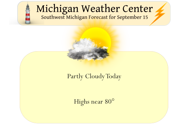
We have now reached the midpoint of September and our trend will continue with warmer than normal temps and dry conditions. Yesterday we reached 77° and our morning low was 52°. The rest of the week will be rain-free and partly to mostly sunny. Temperatures are expected to rebound into the 80s late in the week. At this point, we see slight chances of rain over the weekend, about a 30% chance. Sunrise today is 7:22 am and sunset is at 7:52 pm.
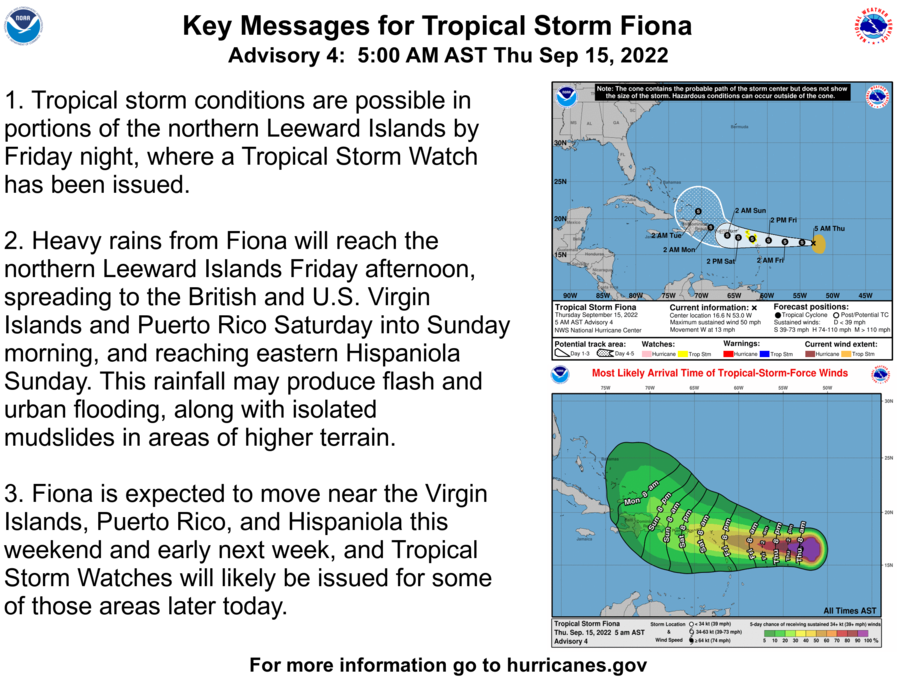
We continue to have a fairly quiet hurricane season, there is one tropical system of note in the Atlantic, Fiona:
Forecast Discussion
-- Fog south this morning, then dry through Friday --

We have another round of some fog ongoing this morning across the
far southern portion of the forecast area this morning. Down there,
a weakening front is nearby, and winds have gone light. This
allowing for a good radiational fog scenario with sufficient
moisture in place. The way the observations are trending, it does
not seem that dense fog will be as much of an issue as it was
yesterday morning. We will keep an eye on it, but this should not be
as big of a deal.

Other than that, we are still expecting a dry and increasingly
warmer air mass to dominate over Lower Michigan through Friday. The
sfc ridge is nearby this morning, and the supporting upper ridge
axis is still to our west this morning. These features will only
slowly shift east through the next 24 hours.

-- Rain chances gradually increase Saturday into Sunday --

We continue to think that we could see a small chance of rain as
early as Saturday, with rain more likely in the late Sunday-early
Monday time frame.

The rain chances begin on Saturday as we see the upper ridge over
the area right now, get flattened a bit with short waves coming over
the top of the ridge. Once the ridge gets flattened enough, we will
see some of these short waves come close to the area. The first of
these will be a short wave coming in from the W/SW on Saturday. This
wave will not have a lot of moisture with it initially, however it
may have just enough that some of the northern areas may see some
rain on Saturday.

We will see better moisture having moved over the area by Sunday,
with a bit more of an organized feature in the form of a sfc low and
moisture transport via a low level jet feeding into the area. The
latest trends with this setup is that the sfc low and front move
through pretty steadily on Sunday night, and sweep most of the
moisture out by Monday morning. There could be some lingering
drizzle behind the system, but any heavier rain potential would be
sept out by then.

-- Uncertain weather pattern next week --

The thought was a couple of days ago that we would see the unsettled
weather Sun-Mon, with a return to drier and warmer air beyond
Monday. The picture has become a little less clear now, as the
amplitude of the ridge has become in question. Some data indicates
that the ridge does not build as much, as the upper low over the
western states stays out just over the Pacific. The other scenario
is that the upper low does come over the western U.S. and the ridge
would build in this scenario.

It seems a little more plausible that the upper low will be slower
to come out, and then the upper jet would stay closer to our area
with multiple waves coming through. This scenario would be a little
cooler and more unsettled than if the ridge would build more. The
bottom line though is that how this situation plays out is still a
bit uncertain.
A newly posted graphic by NWS GR shows Grand Rapids first freeze is generally around October 13th. Lansing at October 1st.
Interesting to note the earliest first freeze ever at Lansing happened August 3rd, 1894 which seems extremely early. Grand Rapids is September 3 in the year 1946.
Big storm in Alaska.
“The storm’s central pressure, a metric which can indicate how much wind and storm surge a system can produce, is forecast to drop to a mind-bending 940 millibars – a number typically found in Category 3 and Category 4 hurricanes.”
https://www.cnn.com/2022/09/15/weather/alaska-typhoon-remnant-storm-weekend/index.html
Based on the article below, 83 days from Dec 20th to March 12th make up almost 80% of all winter output in Southern Lower Michigan. It’s pretty fascinating to me that you could avoid pretty much all of winter if you vacation south for only 83 days.
Those same 83 days make up:
less than 60% of the total winter output in Denver – longer winter season there.
more than 84% of the total winter output in Nashville – shorter winter season there.
Here’s a fun article about winters past.
https://www.mlive.com/weather/2022/09/worst-winters-for-flint-saginaw-bay-city-ranked-and-why.html
Interesting article. I lived in Byron Center (Southwestern Kent County) in 2013-2014 and I believe we picked up somewhere around 122 inches for the season. A winter that I will never forget. After the historic ice storm (one of the biggest I’ve personally seen in my life) on December 21 (no power through Christmas) the winter kept cranking from there. We also had that rare high risk day on November 17th (Particularly Dangerous Situation tornado watch as well) with the wake low behind it with powerful gradient winds and widespread power outages. That 2013-2014 time period was crazy.
Thanks to Mookie who brought up that site last winter I will be using that site this winter as I am sure Mookie will as well. For comparisons last winter ended up on the mild side for much of lower Michigan with a total “point” value of 745 at Grand Rapids, 741 at Flint, 663 at Lansing and 636 at Saginaw/Bay City. Marquette had 2331 good for severe and Port Huron had just 429 for mild. We will see how the upcoming winter will play out.
Slim
Winters have been very mild lately. Most of the severe ones were in the late 50’s to 70’s it seems.
It seems that winters are consistent more mild in recent years… but when there is a disruption to the PV, it gets *really* cold. I think that is what happened in 2013-2014, there were a lot of warming events that caused the PV to dip south
Yes 2013-2014 (and 2014-2015) were really amazing winters… hopefully we get one like that again. I think part of the reason we got so much snow is because November was so cold and we got 31 inches of lake effect snow. We also had the highest snow cover ever for early March.
And Kyle, I didn’t realize that was the same year of that High risk day. I think most of the tornadoes were to our south though
We are long overdue for a legit winter. Perhaps this is the year??
Yes the high risk day was on November 17, 2013. If I remember right it was very mild as well I don’t remember the exact temp. I believe a tornado was recorded up in Newaygo County. One I think in Cass County and another way up near Gaylord. There was a microburst that ripped part of the roof off mattawan high school as well. The worst of the tornadoes were by far to our south in Illinois and Indiana.
Temperatures were in the mid to upper 60’s on that day.
Slim
New CPC is out: a warm October upcoming. Heck, it’s showing warmth until at least January now.
Anyone know why the sky was so white and hazy yesterday? Usually when it looks like that it’s from forest fire smoke but I haven’t read anything recently. The sunset last night looked incredible with the deep orange colored sun.
It is from fires out west in northern California much of it coming from the so call Mosquito Fire.
Slim
Thanks. Figured it had to be smoke from somewhere. Even the moonrise last night was very orange colored.
So a slightly above normal temp week? Get this out of the way before winter sets in! Winter = cold and snow and below normal temps!
We are near the halfway point of September 2022. At Grand Rapids the mean is 37.6 that is a departure of +1.1. At Lansing the mean is 67.9 good for a departure of +2.4 at Holland the mean so far is 37.6 and their departure is +1.9 and at Muskegon Lake Michigan is keeping them warm and their mean is 69.6 good for a departure of +3.5. The mean temperatures have been rather uniform across most of west Michigan. I know that relative to the past some locations are/have been cooler/warmer than other locations such as Grand Rapids vs Lansing.… Read more »
At Grand Rapids the official H/L yesterday was 78/53 there was no rain fall and a reported 95% of possible sunshine. The official overnight low at GRR looks to have been 55 here in MBY the low was 57. For today the average H/L is now down to 74/53 as we continue to see our average slide downward. The record high of 97 was recorded in 1939 and the record low of 36 was recorded in 1953. The next week looks to be rather warm but there is still room for some ups and downs.
Slim
Michael,
Talked to Family on South Florida and they were under a boil water advisory, so they bought a lot of bottles water. Now they have that all clear to drink, but they said we are ready for hurricane season with all that water they bought.
It’s a very cool 53 this morning at my house. I see a 38 up at Grayling. A sign of the direction we will be slowly heading towards.
We’re halfway through September, yet the Atlantic-named storms are only at “F.” Makes me wonder why the experts even try to forecast the hurricane season.
Just like many long range seasonal guesses. Some times the guess looks better than it really is as all in all it is just a guess. But then again when the guess is wrong it can be really wrong.
Slim