
The heat will begin to build into the state beginning today with increasing temps as we move further into the week into the weekend. Chances are once again slim for rain through much of the state with 20% in Grand Rapids, 30% in Kalamazoo with better chances increasing to 60% in Detroit. After the system moves by to the south it appears we will see dry conditions right on through the weekend.
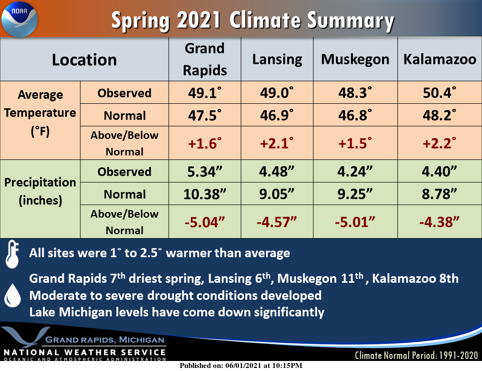
Spring 2021 will be remembered for how dry it was. Most sites were anywhere from 4 to 5+ inches below average with regards to rainfall. Many sites had a top 10 driest spring. This lack of rainfall caused moderate to severe drought conditions to develop over the area. Temperatures were generally 1 to 2.5 degrees above average.
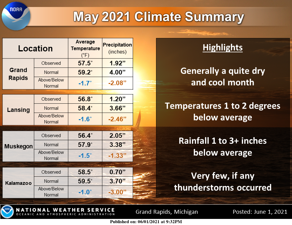
May ended up with below normal temps and much below normal in the precipitation department.
Weather History for SW Michigan
May 30
1972: A tornado damaged a building under construction five miles west of Jackson.
1989: A tornado struck Van Buren County, moving from east of South Haven to south of Pearl. Several grain elevators were destroyed and windows were blown out of buildings.
May 31
1943: A tornado outbreak hit southern Lower Michigan. Ten people were injured as homes were swept away by a powerful tornado that moved southeast of Morrice in Shiawassee County. A tornado killed livestock and destroyed a barn near Morley in Mecosta County. A home near Coopersville in Ottawa County was unroofed by a tornado and three people were injured. Another tornado struck near Bath in Clinton County destroying one barn.
1954: A tornado struck north of Bangor in Van Buren County. Forty barns were damaged or destroyed and one home was unroofed. Damage totaled about half a million dollars.
1998: A squall line of severe thunderstorms moves across Lower Michigan in the early morning with wind gusts between 90 and 120 mph. Thousands of trees are knocked down and hundreds of homes and businesses suffer damage. Sections of the state are declared a major disaster area and thousands are without power, some for several days.
June 1
1934: Blistering heat begins the month in one of the Dust Bowl summers of the 1930s. The mercury soared to 102 degrees at Grand Rapids and 97 degrees at Lansing. The 102 degree reading at Grand Rapids is tied for the highest June temperature with June 20, 1953.
1943: A violent tornado injured ten people as it moved from Ingham to Shiawassee County and left a path of destruction 20 miles long. Over 250 farm buildings were damaged or destroyed, including 39 homes and 52 barns. Another tornado hit between Lansing and Bath, causing damage to several farms.
1998: West Michigan was cleaning up from the tremendous destruction caused by the squall line of the day before. Meanwhile, on Lake Michigan, water levels continued to rise and fall several feet at some locations throughout the day as seiches generated by the extreme winds of the squall line continued more than 24 hours after its passage.
June 2
1910: It was a cold day in June as temperatures in the upper 40s in the afternoon were more typical of late March. The high of 47 at Grand Rapids and Muskegon are the coldest high temperatures on record for any day in June. At Lansing, the high was 49 degrees, second only to the 46 degree high on the previous day for being the coldest June day.
1925: Two people were injured as a tornado moved across central Ionia County. A woman was carried 300 feet and left paralyzed and a man was injured in a barn that collapsed.
1950: Thunderstorms dropped one to three inches of rain across the region. Nearly an inch of rain fell in one hour in Grand Rapids, flooding streets and basements. Lansing had a storm total of 2.30 inches, which was a record for the day.
June 3
1945: An early June cold spell brought widespread frost and freezing temperatures from June 3rd to the 5th. The temperature bottomed out at 32 degrees at Grand Rapids on the morning of the 4th, a record for the coldest June temperature and the latest freeze.
June 4
1925: An early June heatwave began and lasted through the 6th with record highs in the mid and upper 90s.
1860: Powerful thunderstorms moved across Lake Michigan in the evening. Sailors reported seeing a very large waterspout moving across southern portions of the lake. The storms eventually reached West Michigan, causing damage in the Grand Haven area.
June 5
1905: Torrential rains soaked much of the region. From four to six inches of rain on June 5th and 6th caused widespread flooding. Both Lansing and Grand rapids set records for daily rainfall in the month of June with 5.47 and 4.22 inches, respectively.
1930: A tornado moved across southern Clinton County from near Eagle to seven miles north of Lansing. One farm home was torn to splinters and scattered.
Weather History for SE Michigan
May 30
On May 30, 1953, In the Detroit area, Softball size hail was recorded!
May 31
On May 31, 1998, a severe squall line moved through all of Lower Michigan during the early morning hours. Wind gusts were measured at 86 mph at the Tri-Cities Airport and at 81 mph at the Essexville Coast Guard.
On May 31, 1999, an F2 tornado moved through the city of Midland at 5:38 PM causing destruction for 2 miles. The total amount of damage caused by this tornado was estimated to be $150,000. This tornado ties with an F2 tornado that moved through Midland County on April 14, 1974, as the strongest tornado to ever hit Midland county.
Also on May 31, 2011, an EF1 tornado with maximum winds estimated to 95 mph hit central Bay County. The pathwidth was 200 yards with a path length of 8.4 miles. The tornado started near Parish road and 11-mile road just west of the community of Beaver. The tornado then moved through Beaver, crossed Interstate 75, and finally across the south part of Linwood before moving out to Saginaw Bay. A barn was destroyed and homes were damaged near Beaver, mostly to garages and roofing material. Numerous trees were uprooted with snapped large limbs.
June 1
On June 1, 1973, an F1 tornado hit Saginaw County at 6:15 PM and caused $250,000 in damage. Also, on this day in 1910, the temperature rose to 104 degrees in Saginaw County. This is the earliest a 100-degree day has occurred in the year for our County Warning Area!
June 2
On June 2, 1988 rain was actually recorded at Saginaw (.11), Flint (.47) and Detroit (.37). This was one of just three days in June 1988 that had rainfall. This lead to the driest June on record in Flint (.63 inches total) and Saginaw (.61 inches), and the second driest in Detroit (.97 inches).
On June 2, 1971, an F1 tornado hit Genesee County at 5:12 PM and caused $250,000 in damage.
June 3
On June 3, 2007, the remnants of Tropical Storm Barry combined with an upper low pressure produced widespread heavy rainfall. The heaviest of the rain fell over southwest Livingston County with estimates up to 5 inches. This caused some flooded roads but also raised lake levels on the many lakes in that area, threatening local property.
Also on June 3, 1973, two F0 tornadoes hit Genesee County between 5:15 and 5:30 PM, but only caused about $3,000 in damage.
June 4
On June 4, 2010, a severe thunderstorm developed over southwest Oakland County. The storm produced hail up to 2 inches in diameter and downed numerous trees in Novi and Northville.
Also on June 4, 1998, the latest record low for Flint for the month of June occurred on this day. The temperature dropped to 33 degrees, which ties a record previously set on June 1, 1966.
June 5
On June 5, 2005, widespread severe weather hit Southeast Michigan. Thirty-four warnings were issued with 52 distinct severe weather events reported including one F0 tornado near Hemlock. Hail was up to golf ball size, and wind gusts up to 80 mph were estimated in Bay City, Hemlock, New Hudson, and Monroe.
On June 5, 1998, the high temperature only rose to 53 degrees in Detroit. Scattered showers during the afternoon forced temperatures into the 40s, and spotters reported sleet with some of them.
In 1953, tornadoes hit both Wayne and Saginaw Counties. An F0 tornado hit Wayne County at 5:05 PM and an F2 tornado hit Saginaw County at 7:00 PM and caused $25,000 in damage
Also on June 5, 1905, an estimated F5 tornado moved through Tuscola and Sanilac counties in the middle of the afternoon. The tornado moved from Colling to McGregor. The worst of the damage was near Shabbona in Sanilac County where at least three farms were destroyed. Five deaths and 40 injuries resulted from this tornado.
Forecast Discussion
- Isolated showers today mainly southeast this afternoon

PWAT values will be on the climb today from the south as the wave
of low pressure in the Lower OH Valley lifts northeast. Radar does
show the showers in Southern IN lifting northeast.  Uncertainty
exists as far as how much precipitation will be around today.
The NAM appears to be an outlier showing the low level jet aimed
at our southern counties later today into tonight. Most of the other
models like the RAP13 angle that feature to the east of our CWA.
The RAP13 seemed to have a good handle on the setup at this time.
Thus it looks like the far southeast parts of the CWA will be on
the northwest fringe of the steadier shower activity. For now we
will maintain the higher POPs down towards Jackson for later today
into tonight...and feature isolated showers elsewhere.

- Elevated showers/storms possible mainly Thursday night

A weak mid level wave and associated low level jet is shown to
push in from the northwest Thursday night. Elevated instability
will be around as well...generally weak. Thus a few showers and
thunderstorms look possible. Models are in general agreement on
this scenario. We will feature chance POPs for this event at this
time.

- Heating up over the weekend into next week

With the passage of the weak wave Thursday night...deep southwest
to west flow develops upstream for Friday into the weekend. This
will advect a very warm/hot airmass into the Great Lakes region.
Temps at 850 mb are shown to climb to the upper teens to near 20
deg C. Mixing to that level will support high temps into the upper
80s to near 90 degrees. The latest trend in the models is to hold
this pattern through much of next week. Heat index values in the
90s will be likely at times as the surface dewpoints climb through
the 60s to perhaps near 70 degrees.
I’m am really tired of the rain just barely missing us. It seems to have been this way all spring. Grrr…
And it’s not just my lawn. The rivers and lakes are way down.
This last week in a half has been so beautiful and nice with cool nights not the sh** show that starts this weekend with the heat still don’t understand why some on here are in love with it but then again are they really?? Or just all talk lol well hate to see our below average May go but then again September is only 3 months away it will be here before we know it Fall that is! These next couple of weeks are the longest days of the year wait a minute already???! On that thought Shuuu have a… Read more »
Wow, someone needs to take there meds.. Lol. It’s called having 4 seasons. You should know this by now living here. LOL.
Why because I dont enjoy heat as most don’t take meds hu? wow Jeff just wow ha ha ha! INDY..
WOOD has three 90 degree days upcoming this weekend! Bring on more heat!
It was a warm meteorological spring after a warm winter! Will it be a warm summer too?
Yesterdays CFSv2 long range guess is hinting at a very warm start to June and then a turn to cooler and wetter the last part of June. But we shall see how that plays out.
https://www.cpc.ncep.noaa.gov/products/people/mchen/CFSv2FCST/weekly/
As for the summer as a whole I would expect the same as we have seen the last couple of months. Long range outlooks are not more that just a guess so anyone’s guess is as good as the next persons. My guess for the summer of 2021 “near average”
Slim
When the NWS says few if any thunderstorms they are not kidding. There were a total of 3 reports of thunder in April and only 1 in May. One flash of lightning or one clap of thunder counts as a “thunderstorm” I wonder how many time in the past has it gotten to June with so few. At Kalamazoo there was only one report of thunder so far this year.
Slim
WHAT??! Spring ended up ABOVE average in temps? How can this be? We’ve been told by a couple posters over 400 times about what a cool Spring we were having. Swing and a miss.
This past spring March was much above average +5.5. April was +0.9 and May was -1.7. But since April 15 it has been below average and that is with 7 days in May with highs of 80’s. So the case can be made that this spring was a “front loaded spring” if that means anything.
Slim
Love the facts and yes since April 15th almost 2 months ago it’s been cooler then normal thank you Slim …INDY
Rock n slim! For the last month and a half below normal temps! Who knew?
That’s way in the past like Fauci’s career after the email dump!
Fauci rocks and he is the leading infectious disease scientist on the face of the Earth! He has done an incredible job! That God for Fauci! I love it!
Hmmm…the Bible has something to say about idol worship like your Pope Fauci:
Romans 1:23
And instead of worshiping the glorious, ever-living God, they worshiped idols made to look like mere people and birds and animals and reptiles.
Sorry I don’t put any faith in mortal geriatric bureaucrats, whose policies have doomed thousands of businesses in Michigan and done very little in changing the fate of Covid in the US.