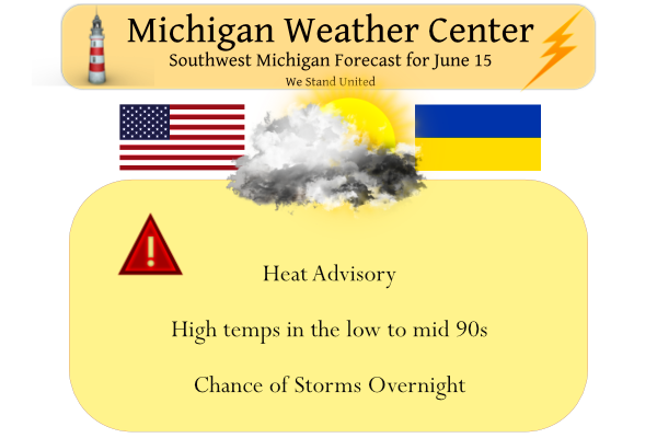
We have another hot, humid day in store. Most locations inland of Lake Michigan will have highs well into the 90s with heat index values over 100 degrees. Yesterday’s high was 94° and the low was 69° with dewpoints holding in the low 70s.
Our weekly weather history post will move to tomorrow.
Air Quality Alert
The Michigan Department of Environment, Great Lakes, and Energy has
declared Wednesday, June 15th to be an Action Day for elevated
levels of ozone. Pollutants are expected to be in the unhealthy for
sensitive groups range.

The Action Day is in effect for the following Michigan counties...

Mason, Oceana, Muskegon, Ottawa, Kent, Allegan, and Van Buren.
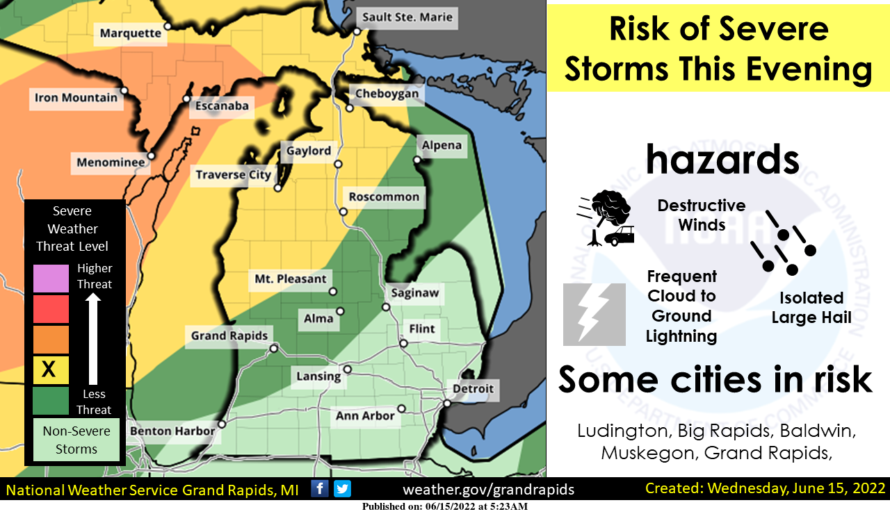
Thunderstorms are expected to move across the area this evening into early tonight. The storms are expected to be strong too severe over most of Wisconsin this afternoon as they move east over Lake Michigan this evening and then into Southwest Michigan after 8 pm. The storms should impact areas northwest of Muskegon first, then continue to move east southeast and slowly weaken as they move farther inland. Damaging winds, large hail, and frequent cloud-to-ground lightning are the expected hazards.
SPC Discussion
 Scattered strong to potentially severe elevated storms are expected
   to be ongoing across portions of IA into WI at the start of the
   period, posing mainly a large hail and damaging gust threat. Despite
   some convective overturning introduced by these storms early on,
   strong diurnal heating is expected to precede the approaching cold
   front, with a feed of steep mid-level lapse rates expected to
   overspread the warm sector across the Upper Midwest, coincident with
   a 70+ kt 500 mb speed max. Strong forcing along the cold front will
   encourage the development of semi-discrete storms that will merge
   into a line while progressing eastward across far northeast IA into
   WI during the afternoon. However, 40-50 kts of 850 mb flow
   overspread by the 70 kt 500 mb southwesterly flow will support
   nearly 50 kts of effective bulk shear. When considering 8+ C/km
   tropospheric lapse rates atop mid 70s F surface dewpoints
   (contributing to 3000-4000 J/kg MLCAPE), sustained supercells are
   expected in the line. The very steep, deep-layer lapse rates will
   support an organized risk of severe wind and hail, with 65+ kt gusts
   and 2+ inch hail possible. The presence of a strong low-level jet
   will also promote modest sized/curved low-level hodographs and
   250-350 m2/s2 effective SRH, with tornadoes possible with any
   sustained supercell structure. Given the very unstable environment,
   a couple of strong tornadoes are possible.

   More isolated strong to severe thunderstorms are possible along the
   trailing cold front by late afternoon across portions of the central
   Plains. While lapse rates will be steep, stronger shear/forcing is
   expected to be displaced northeast. Nonetheless, a couple instances
   of large hail or damaging gusts are possible with the stronger
   storms given the presence of ample buoyancy (i.e. 3000+ J/kg
   SBCAPE).
Forecast Discussion
--Another day of heat today with possible severe storms tonight--

We will be leaving the Heat Advisory as is after the expansion of it
occurred yesterday. It is pretty noteworthy that we are seeing
temperatures this morning at 3 am at some locations still well into
the 80s. These warm temperatures this morning will make it easy to
warm into the 90s this afternoon with a good deal of sunshine
expected. The thing that looks different from yesterday, and would
prevent us from hitting Heat Warning criteria everywhere are dew
points expected to be lower than yesterday. This is likely due to
mixing out some of the very moist air from the rain Mon night.

This very warm air will also continue to cap any convection that
tries to ignite through this afternoon. Forecast soundings indicate
that the cap will be in place from about 2-8k ft agl through the
afternoon.

We will see the chance of showers/storms increase after 00z tonight
from NW to SE, with some of the storms possibly being strong to
severe. After 00z, we will see the cold front and lower heights move
in. These factors will help to erode the cap that is keeping us dry
yesterday and today. There will be a severe line of storms over in
Wisconsin that will try to make its way across the lake and over our
area.

The atmosphere on this side of the lake is not going to be nearly as
conducive for severe weather as Wisconsin. First of all, the storms
that survive the trip over the lake will come in after peak heating.
There will still be a fair amount of MU CAPE based aloft available
for the storms to tap. Another factor is that the upper support and
low level jet is not as favorable as over in Wisconsin either. We
will see a weakening wave aloft to help fuel a few storms, but
nothing impressive, and more so up North. Also, the front will
becoming more parallel with the upper flow which will limit severe
potential.

That said, there does look to be enough shear to allow a weakening
line of storms, and/or its gust front to survive here in a weakening
state. Effective shear values are expected to be around 35 knots or
so. The best chance of this would be across NW Lower. Mid level
lapse rates around 6.5-7 C/km and decent CAPE do support some large
hail potential. DCAPE values over 1,000 would support some
microbursts, although a sfc inversion would buffer that a bit. The
short wave and cold front should be mostly east of the area by 12z
Thu, bringing an end to the rain chances.

--Cooling down through Saturday with mainly dry weather--

There will not be much relief from the heat and humidity on Thursday
behind the front. This front will only be strong enough to bring
temps and humidity levels down a notch or two. The better relief
will come through Thursday night in the wake of a secondary front.
850 mb temps will drop down in the lower teens C, supporting highs
on Friday around 80 with dew points in the lower 50s. These
comfortable conditions will persist through Saturday as Canadian
high pressure moves overhead, and 850 mb temps drop into the single
digits C.

--Heat moves back in late in the weekend with possible storms--

The cooler and drier air will be temporary as expected at this time
of the year. By late Saturday night/Sunday, we will see the upper
ridge building toward the area already. As it builds toward the
area, we will get under the active part of the jet on the periphery
of the heat dome. This would bring a chance of a round of storms,
centered around Saturday night and Sunday morning.

The ridge axis will then build almost directly overhead by late
Sunday, and bring the heat aloft back over the area. This ridge will
then stay over the area through Tuesday. It flattens out some as
energy from the Western trough tries to beat it down some. We should
remain closer to the core of it, and keep the hot and dry conditions
overhead. 850 mb temps are forecast to reach the mid 20s C again, so
90s look likely again next week.
Thunderstorm here. Kinda woke us up. It is pouring out.
Those storms across the lake sure look nasty. Here at my house it’s 92 and sunny currently. Another very hot and humid day. Looks like we get a little break before another warm surge comes back.
95 at the Lansing airport. My thermometer says 96. I can’t remember the last time it felt this hot.
I had to be over by the airport and on my SUV the temperature there was 92 just like the official reading for Grand Rapids. But here at my house the temperature jumped up to 94 and that is what I have on my outdoor reading here as well.
Slim
Back to back 90+ degree days in GR. Heat Index 100+ around the area.
Here are some 2 PM temperature readings along with the dp and heat index for some locations in lower Michigan. Grand Rapids 90 DP 71 heat index 96. Muskegon 86 dp 70 heat index 91. Holland temp 88 DP 71 heat index 94. Lansing 92 DP 74 heat index 102. Kalamazoo 92 DP 70 heat index 98. Detroit 96 DP 72 heat index 105. Flint 92 DP 74 heat index 102 Saginaw 93 DP 70 heat index 99. Traverse City 92 DP 72 heat index 100. Gaylord 90 DP 71 heat index 96. Alpena is the cool spot with a… Read more »
Here at my house I have a temperature of 94 and a dew point of 75.
Slim
93 now in Lansing, which is a record high. The question becomes, will it get much higher?
Up to 100 re-feel here
91 before 11a. Nasty.
Hope you like the heat! Another Omega ridge is setting up after this blowtorch.
Hottest morning since I’m not sure how long! Phew!
86 already at 9:45. Don’t think I’ve ever seen it this warm at this hour in a while.
Temp is up to 82 with a 75 dp – did some light work outside – not much more than that….
87 here now. Hotter than yesterday’s high. Yuck.
I just walked from my hotel to the business college (which I use to work at 😀 ) and I am already drenched in sweat. I’ll probably be stuck here for another 10 hours.
Muskegon and Holland hit 93 yesterday. Cooler towards the lake??
To all the warm weather nuts out there, enjoy the heat index of 100 degrees! Ridiculous!
The official H/L at Grand Rapids yesterday was 90/66 that was the 1st official 90 reading at Grand Rapids for this year. There was no rain fall and 63% of possible sunshine. The Dew Point both officially and here in MBY reached 79 (79.5 here at my house) the overnight low at Grand Rapids was just 78 and if it stays above 76 until midnight that would be a new record highest minimum. Here in MBY the low was a cooler 75. At the current time it is 79 here with a dew point of 73. For today the record… Read more »
So looking back on the Monday storm event- how did the forecast pan out? We had a pretty significant storm move into South Haven in the area of the moderate risk. Winds were over 70mph. There were also a couple of other more minor severe storms along/south of 1-94. But overall the event did not seem “moderate risk level” to me, and I don’t think the other risk levels saw anything besides some general thunderstorms. So I have mixed feelings on the event, but I DO think the NWS pinpointed the bullseye correctly, just maybe a bit off on the… Read more »
Over all the risk area panned out rather good. Remember not every one is going to get a severe storm when there is a risk area just like the vast majority of areas are not going to get a tornado in a tornado watch area. Here in my area there was just a at best average to even below average thunderstorm and not a whole lot of rain either
Slim
Not a whole lot occurred anywhere in West MI other than general thunderstorms. The exception was Van Buren County. Northern Indiana got a significant hit though. Overall this wasn’t a huge event at least for The majority of us. The hardest hit part of the state would probably be Cass and St. Joseph County.
I agree. However I think the morning outlook (a slight risk from GR to the SW) was a better forecast than upgrading to a rare moderate and advertising a widespread wind event. I understand their thinking behind the forecast change and have no issue with adding additional warning to keep people safe. Their general area of highest concern was correct.
I agree. The worst storms occurred in the moderate risk area. Remember, moderate risk does not mean a better chance for more storms or more powerful storms. It only means a better chance for severe weather somewhere in that general vicinity.
Yes maybe I have a misunderstanding of “moderate risk”. There were technically 80+ MPH winds in the moderate risk and they pinpointed the location correctly. So honestly I think I am incorrect with my analysis that they were off on the forecast.
I think it’s more that the public doesn’t have a good understanding of what the NWS is putting out there. I also think that the NWS could do a better job of communicating with the public. Just my thoughts.
Maybe I can get the o.k. to hook up a sprinkler in front of my booth at the farmers market, so that I can cool off when I’m not sharpening…
You might be the most popular booth there…everyone running through that sprinkler.. stay safe!!