Yesterday was one of those days we have come to expect in the late fall with lots of clouds and gloomy weather. Today will be our best day to see some sun for the rest of the week and tomorrow will be our warmest day. For tonight and tomorrow, a low-pressure system and associated cold front will approach from the west, bringing a period of rain for many areas. Colder air returns for Wednesday night and beyond. If you haven’t raked up all your leaves yet they are a wet mess waiting for you. Yesterday’s high was 38° and the low was 32°.
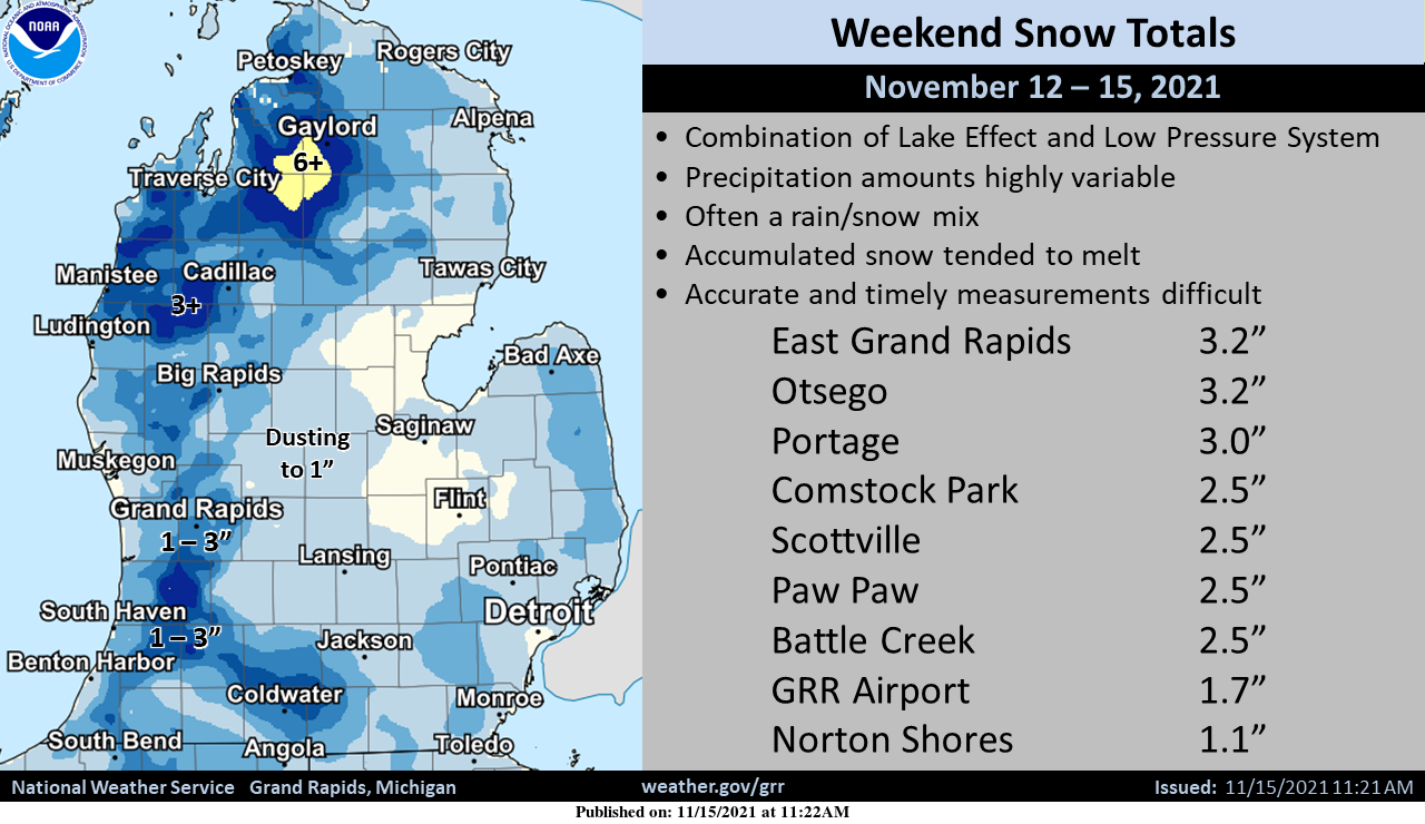
Whether or not you had snow stick this weekend or there is any still around after melting, it was a decent dress rehearsal for the winter to come. Snow amounts were highly variable but a few locations saw enough to slow down highway traffic or cause power outages from falling tree limbs. We lost power in western and northern Otsego for an hour.
Forecast Discussion
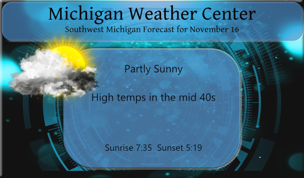
-Brief mid week warm-up followed by another cool down

We have a period of shortwave ridging aloft moving overhead today
between our old upper trough now over New England and the next
one approaching from the Pacific Northwest. This will lead to a
dry weather day and slightly milder temps, with even some
potential for seeing some sunshine.

The current lingering low clouds should eventually be scoured out
today by drier and increasingly mixy southeasterly low level
flow. However considerable high level cloudiness will be streaming
in from the west. Upshot should be a partly sunny mid-November
day with highs in the mid 40s.

Surge of low level moisture arrives from the south tonight via a
50 kt low level /925 mb/ jet, with sfc dew points in the 20s and
30s being quickly replaced by values at or above 50 by 12Z Wed.
This sudden change in low level moisture, atop our currently cold
boundary layer/ground, should result in rapid development and
expansion of low stratus overnight. Lift associated with the sfc
warm front approaching from the south should help to squeeze out
areas of light rain/drizzle by morning.

Coverage of rain showers is expected to increase on Wednesday as
digging upper trough approaches from the west, PWATs ramp up over
one inch, and the sfc cold front slowly inches through the area.
With time the rain eventually becomes focused mainly south and
east of GRR for the afternoon and evening, exiting to the
southeast overnight as cold front continues east.

As next upper trough comes overhead on Thursday and H8 temps
around -10C pour in, expect lake effect snow/rain showers to
develop. There is a decent 12 hr or so window in the afternoon
evening when the jet core is south of here and the moisture and
inversion heights are deep enough to support a period of fairly
robust lake effect convection. We could see some localized wet
snow accumulations of a few inches with similar pattern to last
Friday evening. Arrival of sfc ridging overnight Thursday leads to
quick demise of the snow showers though.

At this time the upcoming weekend weather looks fairly quiet in
zonal flow pattern with temps near to slightly above normal.
Pattern then turns more active again for early next week when
next trough and surge of cold air arrives from the northwest. This
may be preceded by a developing/deepening sfc cyclone on Monday
with a synoptic rain to snow/wind scenario before the higher
confidence lake effect pattern settles in, but the details are
still sketchy at this point.
Get ready for a major cold front! Winter is going to rock!
It sounds like it is time to review the FACTS!
1. November will end up with below normal temps!
2. We just had a nice 2 or 3 inch clipper storm roll through our area!
3. The average high temps this time of year is mid to upper 50’s and the average low is low 40’s!
4. The low temps all week into next week will all be below normal and highs will also be below normal other than a day or two!
5. Clearly the pattern has changed and we are in a cool pattern! Who knew?
Well your “facts” for #3 are a bit off. Average high temp for today is 47 and the average low for today is 33. You’re off by about 10 degrees. And might as well add:
6. We are currently below average in snowfall.
https://forecast.weather.gov/product.php?site=grr&product=cli&issuedby=grr
Good catch!
Lows in the 20’s last night cold …Who Knew?? InDY
Above average temps through the weekend. I love it! Another November with practically no snow?
The overnight low here at my house dropped down to 26 and that is the coldest it has been here this season so far. It is now clear here with a temperature of 33 Driving around the city of Grand Rapids yesterday and there are still a lot of leaves on some trees in the city and some rather good color as well. We are now at the midway point for November 2021 and so far the mean at Grand Rapids is 42.0 that is a departure of -0.8 there has officially been 0.86” of precipitation and 1.7” of snow… Read more »
It has definitely been a chilly November so far. Looks like next week might be pretty cold with highs in the 30s. However we have not had any abnormally cold highs/lows so far. Sometimes in mid November we can dip into the teens, which we have avoided so far. The lake is still warm so any cold blasts will probably have some decent lake effect snow with them. The discussion says “This may be preceded by a developing/deepening sfc cyclone on Monday with a synoptic rain to snow/wind scenario before the higher confidence lake effect pattern settles in, but the… Read more »
Very cold nights are with us! Get ready for some big snowstorms this winter!
Lows in the 20’s this morning felt more like December not November keep it going!! InDY