After a cold, blustery, snowy day yesterday, the lake effect snow machine will shut down and the sun will slowly return for a more pleasant day today and the snow will begin melting again.
On the 17th we had 12 hours of daylight as we cross over to the spring equinox tomorrow the nighttime hours have begun to decrease.
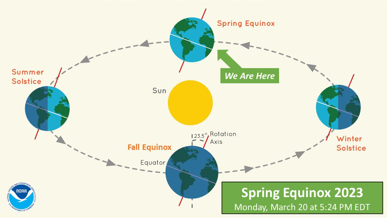
On Monday at 5:24 PM, the spot on Earth at which the sun is directly overhead will cross the equator into our (northern) hemisphere, marking the spring (vernal) equinox. This spot will continue northward until June 21 (the summer solstice), when its northernmost position will be attained. The sun will remain “above” the Northern Hemisphere until September 23 (the fall equinox), when this spot will again cross the equator, but southward. Here in the Northern Hemisphere, periods of daylight have been steadily lengthening since December 21 (the previous winter solstice). The spring equinox then begins six months during which the daily periods of daylight will exceed those of night.
U.S.A and Global Events for March 19th:
1907: The highest March temperature in Oklahoma City, Oklahoma, was set when the temperature soared to 97 degrees. Dodge City, Kansas, also set a March record with 98 degrees. Denver, Colorado, set a daily record high of 81 degrees.
1948: An estimated F4 tornado moved through Fosterburg, Bunker Hill, and Gillespie, Illinois, killing 33 people and injuring 449 others. 2,000 buildings in Bunker Hill were damaged or destroyed. The total damage was $3.6 million.
2003: One of the worst blizzards since records began in 1872, struck the Denver metro area and Colorado’s Front Range started with a vengeance. Denver International Airport was closed, stranding about 4,000 travelers. The weight of the snow caused a 40-foot gash in a portion of the roof, forcing the evacuation of that section of the main terminal building. Winds gusting to 40 mph produced drifts six feet high in places around the city. Snowfall in the foothills was even more impressive. The heavy wet snow caused numerous roofs of homes and businesses to collapse. The estimated cost of property damage alone, not including large commercial buildings, was $93 million, making it the most costly snowstorm on record for the area. In Denver alone, at least 258 structures were damaged. Up to 135,000 people lost power during the storm, and it took several days for power to be restored. Mayor Wellington Webb of Denver said, “This is the storm of the century, a backbreaker, a record-breaker, a roof breaker.” Avalanches in the mountains and foothills closed many roads, including Interstate 70, stranding hundreds of skiers and travelers. The Eldora Ski area 270 skiers were stranded when an avalanche closed the main access road. After the storm, a military helicopter had to deliver food to the resort until the road could be cleared. Two people died in Aurora from heart attacks after shoveling the heavy wet snow. The National Guard sent 40 soldiers and 20 heavy-duty vehicles to rescue stranded travelers along a section of I-70. The storm made March 2003 the snowiest March on record, the fourth snowiest month on record, and the fifth wettest March on record. The total of 22.9 inches is the most significant 24-hour total in March. The storm also broke 19 consecutive months of below-average precipitation for Denver. The 31.8 inches of snow was recorded at the former Stapleton Airport in Denver for its second-greatest snowstorm on record (the greatest was 37.5 inches on 12/4-12/5/1913) with up to three feet in other areas in and around the city and more than seven feet in the foothills. Higher amounts included: Fritz Peak: 87.5 inches, Rollinsville: 87.5 inches, Canin Creek: 83 inches, Near Bergen Park: 74 inches, Northwest of Evergreen: 73 inches, Cola Creek Canyon: 72 inches, Georgetown: 70 inches, Jamestown: 63 inches, Near Blackhawk: 60 inches, Eldora Ski Area: 55 inches, Ken Caryl Ranch: 46.6 inches, Aurora: 40 inches, Centennial: 38 inches, Buckley AFB: 37 inches, Southwest Denver: 35 inches, Louisville: 34 inches, Arvada: 32 inches, Broomfield: 31 inches, Westminster: 31 inches and Boulder: 22.5 inches. This storm was the result of a very moist intense slow-moving Pacific system that tracked across the four corners and into southeastern Colorado, which allowed a deep easterly upslope to form among the front range.
Grand Rapids Forecast
3 19 grrLansing Forecast
3 19 lanKalamazoo Forecast
3 19 kzoForecast Discussion
-- Lake-effect snow showers ending this morning, then clearing --

Lake-effect snow showers/flurries continue to be sampled by KGRR
radar and area surface obs, but overall coverage/intensity has waned
in recent hours. In some areas northwest of Grand Rapids (e.g., near
Muskegon), persistent reflectivity returns are noted, but surface
visibilities are unrestricted. Here, an appreciable subcloud dry
layer may be resulting in virga, given the sizable surface
dewpoint depressions in recent obs at MKG/FFX/LDM.

As the morning progresses, the loss of pronounced low-level cyclonic
curvature will result in weakening boundary-layer convergence/lift
and contribute to lowering inversion heights amid large-scale
subsidence. Beneath this lowering inversion, boundary-layer moisture
will be gradually removed from the overlying DGZ. These factors
should ultimately result in the cessation of lake-effect snow
activity later this morning. Once lake-effect clouds dissipate--
aided by the onset of low-level warm advection--abundant sunshine
is expected area-wide today.

-- Chance of light rain/snow Mon evening/night --

Guidance suggests that a quasi-stationary front will likely be
draped across the region on Mon evening. Lift near this frontal zone
will be provided via frontogenesis in conjunction with the
approach of a low-amplitude shortwave trough / vort max. Light
precip is possible, as indicated by numerous EPS and GEFS members.
Thermal profiles support rain and/or snow, but amounts are
expected to be light (< 0.1" liquid).

-- Light rain likely Tue night into Wed morning --

Models suggest that a midlevel shortwave trough will emerge from the
WY Rockies on Tue, then contribute to the development of a surface
cyclone over the Northern Plains on Tue night, with the resulting
surface low reaching MN/WI by 12z Wed. Southeast of this low, the
presence of low-level warm advection and associated forcing for
ascent, along with increasing PW (~0.6" in the EPS mean), should
support precip (likely rain) over much of the area. EPS-median
precip amounts during this timeframe are light, generally in the
range of 0.1-0.2".

-- Wed night/Thu and beyond --

EPS and GEFS ensemble means both depict a midlevel trough over
the SW CONUS at 12z Thu, with an amplifying downstream ridge over
the central/eastern CONUS. A pronounced, west-east-oriented
baroclinic zone will likely be situated from the High Plains to
the Great Lakes on Wed night and Thu.

There is a broad signal for two possible precip episodes affecting
the region later in the week. The first is on Wed night into Thu in
conjunction with a frontal wave propagating along this baroclinic
zone, with mainly rain favored. Another period of precip is possible
on Fri-Sat, but forecast uncertainty in this timeframe is
considerable. The 00z deterministic ECMWF solution, for example,
depicts a deepening cyclone over southern IL at 00z Sat. However,
this solution currently has tenuous support from the latest
available (12z Sat) EPS ensemble, with EPS members loosely clustered
around a mean position that is southeast of the deterministic
solution. The 00z deterministic GFS does not develop a prominent
cyclone and instead suggests that a frontal wave will pass south
of the region, with reasonable support from the GEFS.
Is winter dead yet? What a joke!
I would like to see 2 more snowstorms before Spring weather hits! Let it snow, let it Snow, let it snow! Rock n roll baby!
Bring it!
https://www.pivotalweather.com/model.php?m=ecmwf_full&p=sn10_acc-imp&rh=2023031912&fh=240
Pick up 6 inches of fresh snow out in my hood from this storm it was a very cold snowy day yesterday sometimes white out conditions not to shabby going into the lsst part of March!! Sit down I am officially at 116.4 inches of snow since about November 23rd out in my hood .. This has been a record breaking Wimter in lower Michigan right on!! INDY
Who would have thought?
Every time I check the iPhone weather app, the temperature seems to fluctuate about 10 degrees for next weekend and the week after. It showed highs around 50 yesterday, and now shows highs around 40. Which would be about 10 degrees below average… we must be close to a cutoff line towards late next week with that storm system
Which means more snow ….Right on!! INDY
Wow, wow , wow! The RDB nailed another one! GR has picked up 4+ inches of snow from this event! Bring on the next storm! Rock n roll will never die!
https://www.pivotalweather.com/model.php?p=snku_acc-imp&rh=2023031906&fh=228
If the CFSv2 plays out the next 4 weeks look to stay on the cold side.
https://www.cpc.ncep.noaa.gov/products/people/mchen/CFSv2FCST/weekly/
Slim
That is no surprise!
+1000 INDY
It is now the 3rd snowiest winter in Grand Rapids after yesterdays snow. What an awesome winter!
You mean winter is not dead yet like some have been saying for weeks on end?
Today the sun is above the horizon around 12H 8M that is about the same as it is on September 22nd
Slim
The official high of 27 at Grand Rapids was recorded just after midnight and the low of 15 was set at 9AM. There was 0.12” of precipitation that fell as 4” of snow fall for the season GR is now up to 109.2” for March there now has been 22.1” of snow fall. Between snow squalls there was 47% of sunshine yesterday. Overnight with clear skies it has now fallen all the way down to 15 here in MBY. And I have 3.5” of snow on the ground. For today the average H/L is now up to 46/28 the record… Read more »