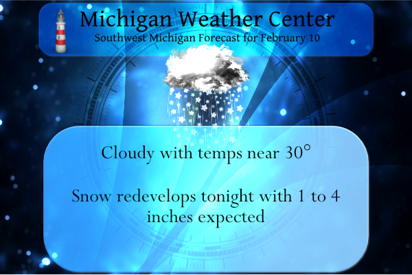
We have a mix of rain and snow this morning with a temp of 30° at 6 am. Yesterday we had a high temp of 41° and a low of 27°.
Early morning snow showers will give way to mostly cloudy skies. It will be colder than yesterday with highs near 30 degrees. A push of warmer air will result in a lake-enhanced snow event early Friday morning, with our northwest Lake Shore counties getting 2 to 4 inches of wind-driven snow. The rest of this area will have around an inch of snow.
...WINTER WEATHER ADVISORY IN EFFECT FROM 10 PM THIS EVENING TO
7 AM EST FRIDAY...

* WHAT...Snow expected. Total snow accumulations of 2 to 4
  inches. Winds gusting as high as 40 mph.

* WHERE...Portions of Northwest Lower Michigan.

* WHEN...From 10 PM this evening to 7 AM EST Friday.
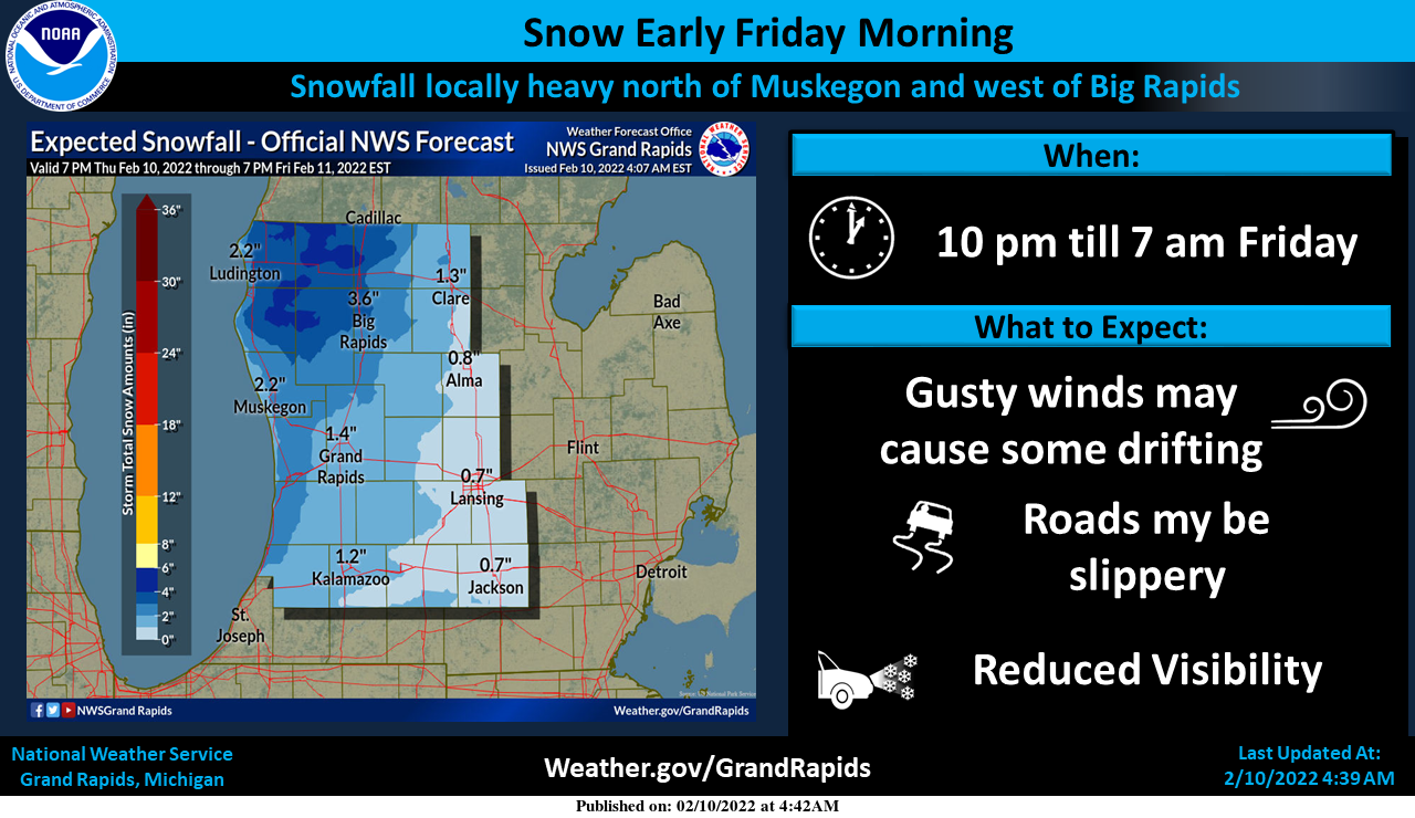
Snow is expected to develop across the area by late this evening. Most areas, near and east of US-131 will see an inch or less of snow. However, locations north of Muskegon and west of US-131 are expected to see a lake enhanced 2 to 4 inches of snow overnight. Most of the snow will fall between midnight and sunrise Friday and is expected to be heavy at times with some blowing and drifting, this will mostly be west of Big Raids to the lakeshore and north of Muskegon. This will likely result in a much slower morning commute on US-31 from Muskegon to Ludington and north Friday morning. Lesser impacts are possible along US-31 south of Muskegon.
Friday will be warmer than yesterday with highs getting to near 40. Then an arctic front comes through and temperatures will mostly be in the single digits at night in the teens during the day on both Saturday and Sunday. Expect lake effect snow showers west of US-131 Saturday and Sunday.
Long-range guesses are trending towards wetter and warmer than normal conditions beginning later next week suggesting the loss of our snowpack as temps could rise well into the 40s.
Forecast Discussion
...Breezy with snow tonight...

A cold front currently extends from the Thumb southwest to near
Chicago. Light snow along/ahead of the front has diminished somewhat
behind the front, but likely won`t end until after the upper trough
passes through mid morning. This afternoon will be dry as weak
ridging builds in ahead of the next system.

We`re likely to see a quick burst of warm advection snow after
midnight tonight. Isentropic lift as noted on the 290K surface is
really strong with 55kts perpendicular to the pressure surfaces.
This results in a very quick saturation of the surface such that
condensation pressure deficits fall from over 100 mb to less than 5
mb around midnight. We`ll see snow develop quickly in this scenario.
Two to four inches of snow is likely northwest of a Kalamazoo to Mt
Pleasant line...highest west of US-131. Almost all of this will
occur from 06z-12z. Both the ECMWF and GFS ensembles paint around 2
inches at Grand Rapids.

Temperatures will warm to close to 40 Friday in the southwest flow,
but that will quickly change as the next cold front blows through
Friday evening. H8 temps fall from -8c to -20c between 00z and 12z
Saturday. Despite the cold temps over the lake, inversion heights
fall to around 4k ft which will limit lake effect snow. The
northwest wind will confine any snow to areas west of US-131.

...Dry early next week, then a potential storm...

High pressure will roll into the Great Lakes for a couple of days
ahead of the next system. For a couple of model runs, we`ve seen a
develop storm in the southern Plains progd to move northeast toward
Michigan. In some respects, this system looks a lot like the one
last week that produced heavy snow south of I-96. However next
week`s system is progd to be 75 miles farther north. So we may see
more rain out of it. The GFS ensembles have trended wetter with the
system and show 0.75" qpf with several members showing 2". ECMWF
ensembles are closer to 0.5" qpf and top out under 2". The northern
cwa may see mostly snow. This is a system that merits watching,
especially as it pertains to hydro issues.
More great news, snow is heading right for us tonight! Get ready for a quick 1 to 3 inches! Let it snow, let it snow, let is snow!
Breaking news>>>>>>>All the latest models give us a snowstorm next week, not rain! How is that possible! I love it! Rock n roll will never die!
Oh I’ve marked down your 24 inch prediction from your trusty maps from yesterday! We’ll circle back on the 19th to see how your prediction pans out!
Looking like a lot of rain by the end of next week! Guess some people are just in denial!
The EURO model rocks and here’s hoping
For a monster snowstorm while some are saying winter is over! Bring it on and just hammer us!
Every year it’s the same thing, BIG SNOWSTORM IN 2 WEEKS, then we get some flurries on that day and end up with below normal snowfall for the season! Some people never learn!!
Plenty of Mid 40’s coming up!! Plenty of melting going on!! Who knew?!?!?
https://weather.com/weather/tenday/l/b4ea0280869baa46799dc75eacef8904785ec43ad2f6fb098355fbc208a55e2c
Blow torch on it’s way! Prepare now!!! BRING IT!!
It will be interesting to see how the models go in a back and forth battle in where the area of Low pressure will track. The latest 12Z GFS has the low over Ottawa County, meanwhile the latest Euro run has the low going from Missouri up into Ohio putting us in the cold sector with possibility of >6” for some areas. We shall see how things evolve.
No doubt, as of right now the EURO hammers us with a big snowstorm by the end of next week, yet the warm weather fanatics are talking like winter is over! This happens every year about this time of year! Bring on the snowstorm baby!
We will definitely need to watch river rises next week if the system ends up being mostly rain. We have had quite a few floods in recent years in the late winter and early spring. The Red Cedar at MSU seems to flood almost every year now.
The only good news is we are in abnormally dry conditions. And it could still be snow, it is too early to tell.
If we do get heavy rain it will definitely cause Hydro issues with all the river ice and the frozen ground.
Is the snow ever going to stop???….Pushing 50 days now with snow on the grounds amazing..InNDy!!
It has been a spectacular winter with more snow on the the way! Some people are in denial!
A weak geomagnetic storm “puffed up” the earth’s atmosphere just enough that it brought down 40 Starlink satellites before they could reach their orbit height. Several videos of them burning up in the sky. Crazy stuff!
https://spaceweather.com/
40’s in Lower Michigan yesterday, 40 Friday, and even more 40’s next week. The warmup is coming earlier than predicted! That CPC is a thing of beauty!
Meanwhile back to reality! We have 5 more weeks of winter left and we will be getting pounded with snow tonight and then the deep freeze this weekend! Get outside and enjoy winter in west MI! Who wouldn’t want snow this time of year? Incredible!
Pounded with 1-2″ and then a 40 degree warmup LOL
I have been and I have been ice fishing more then ever this Winter such fun….InDY