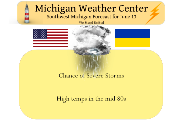
We had a high temp of 80° in Otsego yesterday, the low was 62°. Today it will become a bit more uncomfortable with temps rising into the low to upper 80s. The warmest will be in Grand Rapids, Kalamazoo, and surrounding areas.
One or more rounds of thunderstorms are expected this afternoon into the evening. Some of the storms could turn severe with damaging winds the primary risk. In addition, locally very heavy rain and frequent lightning may occur. Anyone with outdoor plans should be prepared to move indoors should storms head your way.
Heat and humidity will reach oppressive levels on Tuesday and Wednesday, where the combination will make it feel more like 95 to 103 degrees, even in the shade. Heat exhaustion is a concern, and hydration and frequent breaks are a must. Temperatures will tend to stay cooler near Lake Michigan beaches, where water temperatures are still only around 60 degrees, though waves and currents may result in a moderate risk for swimmers on Tuesday and Wednesday.
SPC Convective Outlook
 Convection-allowing guidance continues produce a wide array of
   solutions in terms of timing and location of a potential MCS
   this morning into the afternoon. What is certain is that the
   environment will be favorable for widespread damaging wind gusts
   where an MCS ultimately develops. Low to mid-70s F dewpoints reside
   within the mid-Missouri Valley into the lower Ohio Valley already
   and steep mid-level lapse rates should move eastward over this
   low-level airmass tomorrow. 3000-4000 J/kg MLCAPE is probable near
   the surface boundary by afternoon. Deep layer shear will certainly
   favor storm organization. The question will be where and when
   intensification of convection will occur. Consideration was given to
   introducing a 30% severe wind probability/Enhanced area, but
   confidence remains too low. At least at present, portions of
   southeastern Wisconsin/northeastern Illinois into southern lower
   Michigan and adjacent Indiana/Ohio appear to have the greatest
   potential for greater damaging wind coverage. Some wind gusts could
   be significantly severe. Large hail will be possible and a couple of
   tornadoes could occur given the low-level shear near the boundary.
A Mesoscale Convective System (MCS) is a collection of thunderstorms that act as a system. An MCS can spread across an entire state and last more than 12 hours. On radar one of these monsters might appear as a solid line, a broken line, or a cluster of cells. This all-encompassing term can include any of the following storm types:
Mesoscale convective complex (MCC)—A particular type of MCS, an MCC is a large, circular, long-lived cluster of showers and thunderstorms identified by satellite. It often emerges out of other storm types during the late-night and early-morning hours. MCCs can cover an entire state.
Mesoscale convective vortex (MCV)—A low-pressure center within an MCS that pulls winds into a circling pattern, or vortex. With a core only 30 to 60 miles wide and 1 to 3 miles deep, an MCV is often overlooked in standard weather analyses. But an MCV can take on a life of its own, persisting for up to 12 hours after its parent MCS has dissipated. This orphaned MCV will sometimes then become the seed of the next thunderstorm outbreak. An MCV that moves into tropical waters, such as the Gulf of Mexico, can serve as the nucleus for a tropical storm or hurricane.
A derecho (pronounced similar to “deh-REY-cho” in English) is a widespread, long-lived wind storm that is associated with a band of rapidly moving showers or thunderstorms. Although a derecho can produce destruction similar to that of tornadoes, the damage typically is directed in one direction along a relatively straight swath. As a result, the term “straight-line wind damage” sometimes is used to describe derecho damage. By definition, if the wind damage swath extends more than 240 miles (about 400 kilometers) and includes wind gusts of at least 58 mph (93 km/h) or greater along most of its length, then the event may be classified as a derecho.
Forecast Discussion
--Significant squall line remains possible late this pm--

The potential for a fairly strong squall line with some significant
damaging winds remains a distinct possibility late this afternoon
and/or this evening. The most likely area where significant impacts
would be possible continues to be the southern half of the area,
mainly along and south of I-96. That all said, there are still some
details that continue to need to be sorted out with multiple small
scale systems in play and their interaction with each other.

The two main systems that will likely affect the scenario for Lower
Michigan are two MCV`s. The first one is over Eastern SD, while the
other is moving over Eastern NE as of 07z this morning. Our latest
thinking is that we could see at least a couple distinct rounds of
storms, and even maybe some training of storms that would cause some
potential flooding.

We believe that the MCV/wave in NE will be the one that makes it
here first later this afternoon. The very warm and unstable air mass
that is strengthening to our south will be slowly advancing toward
the area. It seems that the arrival of this wave will help to bring
an initial surge of elevated instability to the area on the edge of
a low level jet later this afternoon. The synoptic models are all
holding off the best forcing with the low level jet until later.
This surge is likely to fire off some scattered showers/storms with
the best instability still yet to come in. If the MCV can be strong
enough, and tap enough of the extreme instability to the south, we
could have a formidable line to deal with after about 20z or so.

It seems then that the MCV over SD will move ENE into Central MN
through early afternoon, before being redirected south as the upper
ridge over the Plains amplifies, and we see a NW flow aloft develop.
Most of the CAMs indicate that this will be coming down toward the
after 00z or so, and potentially produce the stronger line of
storms. This seems plausible as there will be more time for the
instability to creep north, and for that MCV to interact with it. It
will be interesting to see how this interaction actually takes
place, and what the results will be on the severe potential.

Aside from the mesoscale details, the potential remains quite high
that wherever this line develops, damaging winds will be likely,
with some being significant over 75 mph. This will be the result of
mid level winds expected to increase to around 60 knots, and
effective deep layer shear 70+ knots. The forcing of the wave, and
cold pool that would develop would help to drive this and bring down
the stronger winds aloft. Hail will be another threat as mid level
lapse rates are well in the 7.0-8.0 C/km range, and the degree of
CAPE available will help that cause also. Also, a tornado can not be
ruled out, especially near the front where convection will be nearly
sfc based, and where there is quite a bit of low level shear
present. Any tornado that occurs would likely be embedded in the
main line.

Another facet to this is the potential of some flooding. The lines
of storms themselves will be moving fast and are not the concern.
The concern lies where training of storms could occur due to the
interaction of the lines, and where they may pivot. Pwats are
forecast to increase to over 2.00 inches, providing heavy downpours
out of any of the storms. If training of storms occurs and these
heavy downpours hold over one area too long, the rainfall amounts
could add up quickly.

--Hot and humid weather expected Tuesday-Wednesday--

We should see convection move out of the area easily by daybreak
Tuesday. This is because the low level jet is forecast to be east of
the area by then. Most of the area will not be quite in the warm
sector yet, as the storms will hold it down a bit. The upper ridge
building, and the shallow nature of the stable layer mixing out
should send the warm front north of the area by mid-late afternoon.

Clouds and some fog will be possible early with the front nearby.
That will clear out then, and temps will make a run into the lower
90s. Combined with dew points in the 70s, heat indices should warm
to around, or just over 100 degrees. We expect that a Heat Advisory
will likely be needed. There is still a little more time to re-
evaluate this, and we have been messaging it plenty already. This
will continue through Wednesday.

--Cooling off and mostly dry late in the week/next weekend--

The period of heat will come to an end with the passage of the cold
front very late Wednesday night and early Thursday morning. This
timing is not very conducive for diurnal heating and maximizing the
the amount of instability. In addition, the best forcing aloft will
be mainly north of our area, as that is where the short wave energy
with the upper jet will be.

A secondary cold front will then coming through toward daybreak on
Friday. This will usher in the more noticeable change in air masses.
With the passage of that front, we will see Canadian high pressure
build down from the NW. The flow around the high will funnel cooler
and drier air in from the NE initially, before the high moves
overhead. This should keep the area cool and mostly dry next weekend.
We got some thunder and lightning here. Lights have been blinking some. 🙁
I love this rain and keep it coming!
Well what do you know! There is a chance of picking up some rain. Bring it!
Well looky here a new Severe Thunderstorm Watch for Kent, Ionia, Clinton, Montcalm, Gratiot, Newaygo, Muskegon, and Oceana County.
This could be the worst GR forecast ever! Forecast = One to two inches of rain and thunderstorms! Actual = virtually no rain and no thunderstorms! Absolutely horrible forecast!
Van Buren is the really the only county that saw impacts. I will say I have not been impressed lately with enhanced or moderate risks here in MI.
Like I mentioned earlier, the models were all over the place just 12 hours ago. It’s difficult to fine tune a forecast without some model consensus.
Yeah there was lots of uncertainty to begin with. I don’t blame any of the forecasters, I seen what they saw. Just didn’t pan out. Good news is no power outages for a lot of us anyway going into the heat these coming days so we can be thankful for that!
A lull right now. Thundering & lightning to the south a s west. Was a bit windy. Stopped raining for the moment. Lightning was going across the sky.
NWS websites are wonky. The national map show a tornado warning in the Chicago area but when you click on that area, all the watches, advisories, and warnings are non-existent. NWS GR is the same way. No watches, warnings or advisories.
Looks like a bust for GR! Nothing new, but bring on the rain! We need rain!
So far not much rain Just 0.03″ here so far.
Slim
It looks like a 100% total bust! The NWS said 1 to 2 inches of rain?
That storm has made landfall near South Haven. There is a lot of lightning with that strom.
Slim
Getting some light rain here at this time. There is a lot of lightning in the storm over the lake at this time. That storm in moving to the southeast and will come ashore in Van Buren county near South Haven. There is also a storm in the Chicago area and off to the SE in Southern Ohio. As for the Grand Rapids there is an area of light rain and not much more on radar at this time. But if you are in or near Van Buren county I would really think about taking cover.
Slim
There is some development near Green Bay. Will check on that later to see if that develops into anything. At this time there is some light rain falling here with a temperature of 76 with a DP of 66.
Slim
Severe thunderstorm watch until midnight for Allegan, Eaton, Ingham and southward.
Here’s the MD:
https://www.spc.noaa.gov/products/md/md1147.html
Radar estimated 70-80mph winds with the storm moving over the lake.
Moderate risk basically along and south of I-94 here in West MI. Portions of the Ohio Valley have been upgraded to a Moderate Risk for the anticipation of a highly organized MCS/possible Derecho developing from a supercell structure across southern WI. Despite the lack of agreement in high-resolution guidance, this supercell is traversing a strong buoyancy gradient (with extreme MLCAPE values exceeding 5000 J/kg noted in the OH Valley). In addition, 40+ kts of effective bulk shear are also present along the buoyancy gradient, which expands across a long west-east corridor over northern portions of the OH Valley. Expectations are… Read more »
Watch coming shortly for southern WI
Numerous trees and lines down in the city of Madison, WI as reported by Law enforcement.
Afternoon Forecast Discussion:
https://forecast.weather.gov/product.php?site=GRR&issuedby=GRR&product=AFD&format=CI&version=1&glossary=1
Wow, significant rain possible: The HREF 24hr localized probability matched mean shows 3 to 6 inches of rain between MKG and JXN.
MD upstream:
https://www.spc.noaa.gov/products/md/md1145.html
I find the Precipital Water Values of 2.00” a 1 day in 10 years part interesting.
I know, right? That’s twice they have mentioned that today.
Be alert far SW Michigan:
https://www.mlive.com/weather/2022/06/significant-tornado-parameter-says-stay-aware-far-southwest-lower-michigan.html
Ottawa, Kent, Ionia and Clinton Counties and points south are under a Heat Advisory. This is for heat index values up to 103 degrees. Get ready for the sizzle. If we DO get the strong damaging winds as forecast and numerous power outages it would not be a good combination.
Let’s hope it misses us.
Here is the written up date that Kyle has mentioned. “…Midwest/Great Lakes… A consequential potential for impactful storms exists today into tonight across the region, potentially including long-lived/intense MCS development, owing to a high degree of moisture and extreme potential instability. However, short-term uncertainty remains high regarding spatial details exists owing to a strong capping inversion, along with guidance variability in terms of timing/spatial differences. Multiple MCVs, albeit generally weakening, are still readily apparent at late morning across portions of Iowa/southern Minnesota into western Wisconsin. Regional WSR-88D VWP data features notably enhanced mid-level winds, particularly by mid-June standards, within this… Read more »
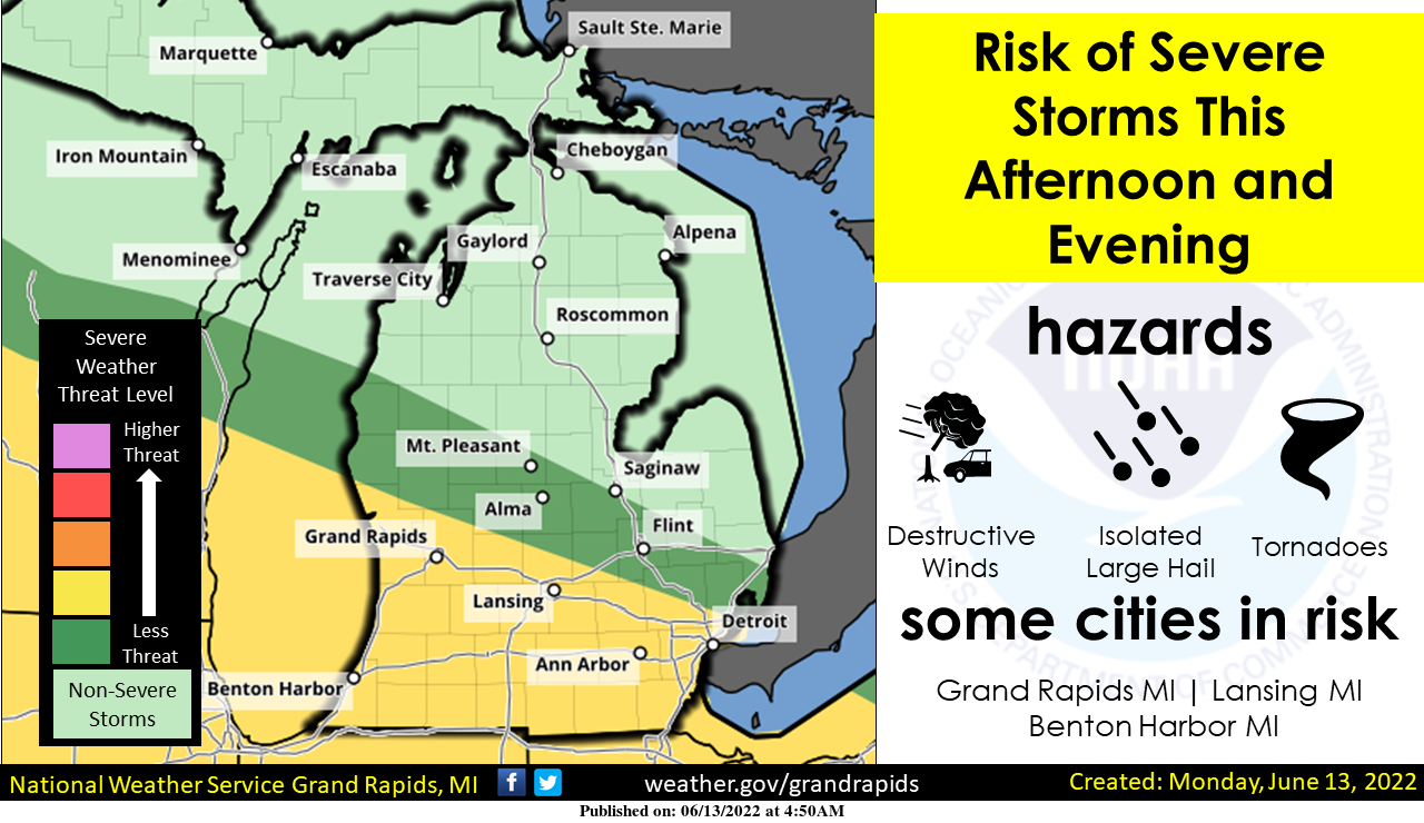
Latest latest update from the SPC has not changed much. They did move the Sig-Wind Hatched area a little further north to include all of Muskegon, Kent, and Ionia Counties and points south. There are not ruling out a possible upgrade to Moderate Risk pending convective trends upstream. So far nothing to impressive out there at the current time. I guess its a “watch and wait” to see how everything evolves. Here is part of the discussion: Where storms do regionally develop, large hail and damaging winds can be expected, along with at least some potential for tornadoes with surface-based… Read more »
For what it is worth there is a 80% chance of a watch for areas to our south and south west. And for our area there is now a 70% chance of thunderstorms. We will have to see how all this plays out.
Slim
Update from NWS GR: The potential for impactful weather from late afternoon into early tonight continues to increase. SPC has increased our threat to “Enhanced”, with the greatest threat being damaging winds, large hail is the second greatest threat, isolated QLCS tornadoes are also possible. As for timing, since the storms are already over MN and will soon be moving into western WI shortly, we are thinking the storms will reach mid Lake Michigan by mid to late afternoon, moving on shore during the late afternoon into this evening. The area of greatest threat is mostly near and south of… Read more »
At the current time there is some very impressive lightning in the storms to our west. Will keep a eye on those storms as they move closer to us. At the current time the storms are moving to the NE if they continued on that track they would move to the north of the Grand Rapids area.
http://www.lightningmaps.org/?lang=en#m=oss;t=3;s=0;o=0;b=;ts=0;y=42.6852;x=-88.3589;z=6;d=2;dl=2;dc=0;
Slim
That line will eventually drope southeast.
All the modles showing that …INDY
https://www.accuweather.com/en/severe-weather/fast-moving-severe-storms-set-to-blitz-through-midwest-mid-atlantic/1200619
https://www.mlive.com/weather/2022/06/destructive-75-mph-wind-a-few-tornadoes-possible-in-new-upgraded-severe-weather-area.html
From Mark Torregrossa:
“The thunderstorms should be entering the west side of Lower Michigan sometime between 4 p.m. and 7 p.m. We are not sure down to the hour just yet. We will know that in the early afternoon. It would then take about three hours for the storms to track across southern Lower Michigan.”
“Here are the cities in the highest risk of severe thunderstorms: Muskegon, Grand Haven, Holland, South Haven, Benton Harbor, Grand Rapids, Battle Creek, Kalamazoo, Lansing, Jackson, Coldwater, Adrian and Ann Arbor.”
Im seeing a Moderate risk coming now for the Grand Rapids area guys this is becoming very interesting 🤔…. INDY
“Spotter activation will be likely this afternoon and evening for
southern areas.”
I’ll be out storm spotting today. I love being out getting reports and communicating with the weather office. I enjoy being in the field to try and get reports and video to keep people safe. I don’t do it for the money.
Good luck and be safe!
Like I was saying yesterday the severe weather is definitely the talk of the week I hope everyone has a safe plan and is ready major power outrages a very good possibility…INDY
A broad upper ridge remains over the southern US today, with the primary band of westerlies extending from the Dakotas eastward into the Great Lakes region. Early morning model guidance suggests a shortwave trough and associated 40-50 knot midlevel speed max is currently over IA. Scattered thunderstorms have been occurring in vicinity of this feature, along with a couple of MCVs noted in radar imagery. Ahead of this shortwave trough, a warm front is lifting northward across IA/IL/IN/OH. Dewpoints in the 70s and strong heating to the south of the front will yield high CAPE values of 3000-4000 J/kg later… Read more »
Interesting that the SPC did an update at 8:24 am.
Looks like the table may be set for some big storms this afternoon. Of course it’s a watch and wait kind of thing. I see the upgrade to Enhanced with the 30% hatched from about Grand Haven to Lansing south. Another update will come at 12:30 so we will see if there are any changes.
I’ll be in East Lansing today, so any reports I provide are from there.
The afternoon discussion will be interesting to read. But regardless, it is sunny, warm, and a bit humid atm (not too muggy yet though)
Slim we have been upgraded to a enhanced area now …Here we go its going to get interesting…INDY
Slim definitely the 1pm up date we will be in a enhanced area for all of lower Michigan I have been tracking these storms all night they are putting out Tornadoe warnings very late last night and now thunderstorm warnings in Minnesota at 8am its heading east for Michigan get a safe plan now major power outrages coming….INDY
The official H/L yesterday at Grand Rapids was 80/59 there was no rain fall and the day had 83% of possible sunshine. All in all a very nice mid June day. The overnight low here was 60 and at the current time it is 65 with clear skies. For today the average H/L is 79/58 the record high of 95 was set way back in 1894 in more recent times a high of 94 was recorded in 1956. With the expected heat for the next two days the record high for Tuesday is 96 and for Wednesday it is 97.… Read more »
Heat and severe storms! Wood raised temps once again!
Excessive heat watch for the SW corner of the state. Looks like half of the US is under some heat-related advisory/warning.
I see the SPC moved the slight risk area a bit farther north. From the marine section of the forecast discussion:
They will also have the potential to
produce meteotsunamis and or a seiche depending on how fast it moves, and what type of pressure changes there are with the line.
I was kind of surprised that there was no enhanced or moderate risk areas. Based on the local discussion I thought that would be a good possibility. Maybe there will be on the update?
Slim
This morning, Blake Harms said that the models were still all over the place.