
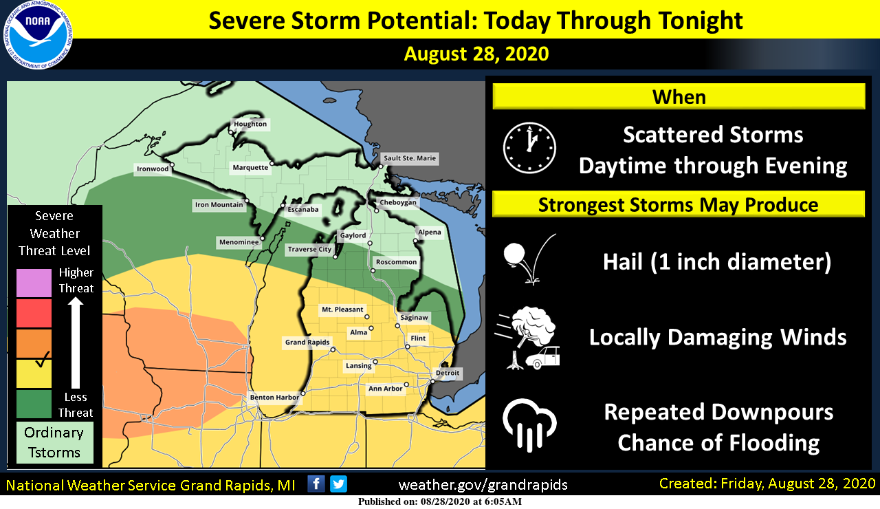
The various models I have looked at are all over the place in precipitation accumulation for today probably because it is hard to guess where the heaviest storms may develop. The NAM NEST is guessing the cold front will move through this evening around sunset thus we have chances of storm development any time today. Currently, as of 6:30 am we have showers across central Michigan.
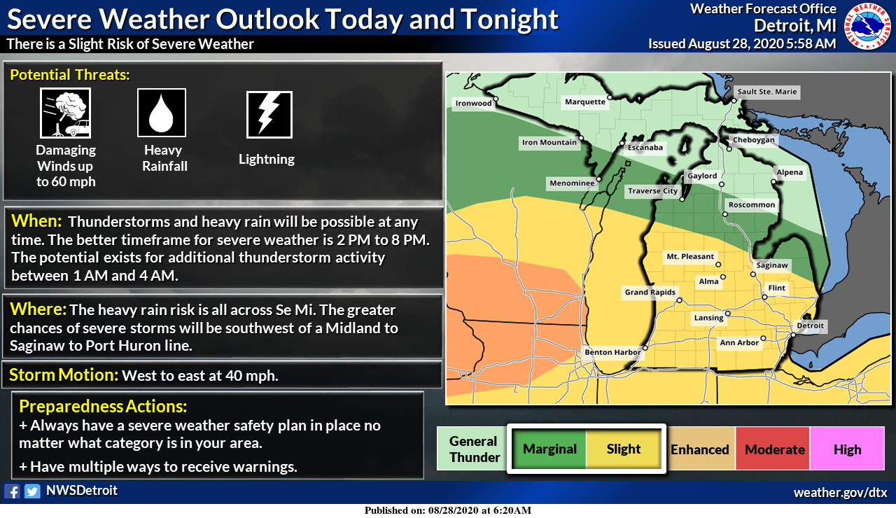
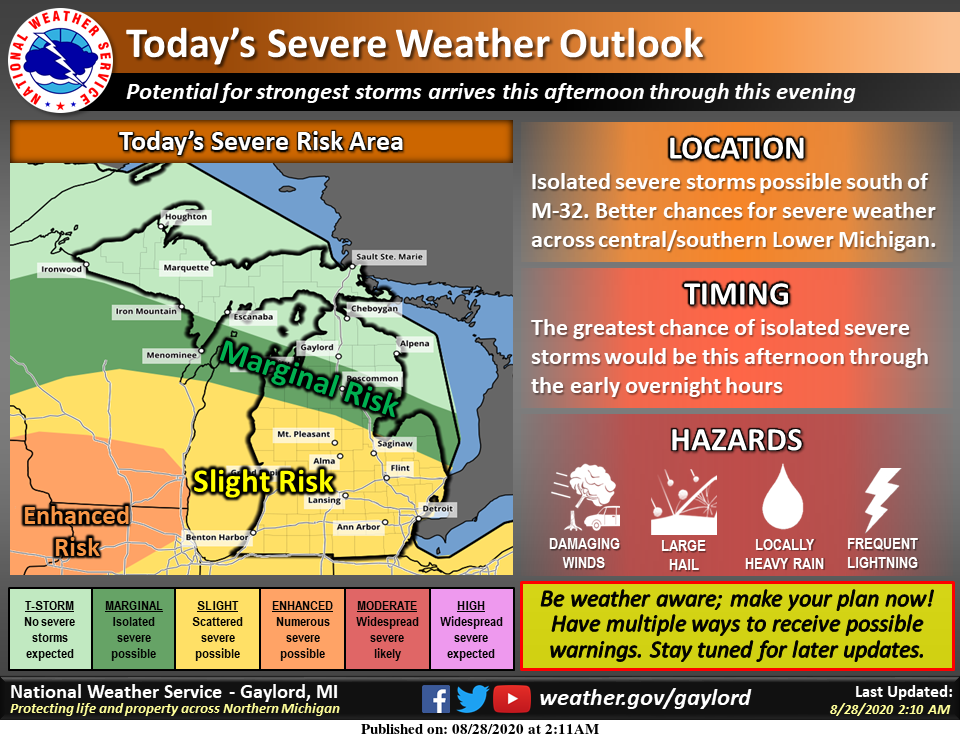
The SPC continues to have placed us under the slight risk for severe weather across most of southern lower Michigan with the enhanced risk to out west.
[columns] [span6]
Southwest
[/span6][span6]
Southeast
[/span6][/columns]
[columns] [span6]
Northern Lower
[/span6][span6]
U.P.
[/span6][/columns]
Forecast Discussion
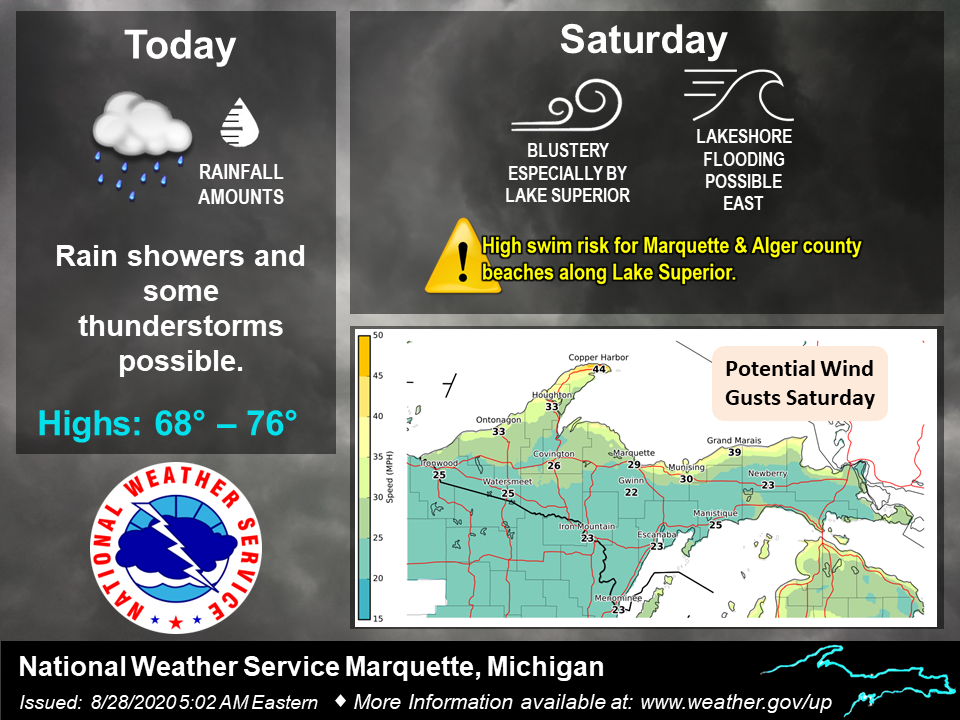
--Showers and thunderstorms through this morning--

Scattered showers and isolated thunderstorms continue to traverse
the region along and north of the I 96 corridor early Friday
morning. These showers and storms are sparking off a warm frontal
boundary that is draped east to west across the region. Looking
at the NAEFS mean PWATS there is a decent amount through 15Z this
morning, though only slightly anomalous. The 850mb jet is similar
with a LLJ max around 25 kts. The latest CAMS continue to show
the convection to continue through 15Z before slackening late in
the morning. Elevated cores and decent rain rates are common with
any thunderstorms. There is a lack of DCAPE so gusty winds are
less of a threat. The rainfall into Friday morning will be set
the stage for the stronger event, Friday night into Saturday.

--Another more potent round of storms through Friday night--

There is a threat for damaging winds and hail, along with
excessive rainfall that could lead to minor flooding. SPC has the
region in a slight risk due to these threats.

Following the boundary and the corresponding warm front will be a
cold frontal boundary that will move through the region Friday
night into Saturday. Looking at the NAEFS Mean PWATS the largest
PWATs are between 00Z Saturday into 06Z. With +3 Std there is a
good signal for significant rain. Along with this is the fact
that the moisture is through the atmosphere and the moisture
transfer is fairly strong considering a stronger LLJ, upwards of
30 to 35 kts. Along with this in the GEFS mean and M climate
anomalies is an anomalous SFC low by 06Z Saturday. The CAMS have
some variation in timing and organization in this system but the
consensus is that lines of showers and storms will move through
between 00Z to 08Z, most likely around 04Z.

--Cooler trends through weekend--

Temperatures will cool down behind the front Saturday. Expect
highs to be back to near normal, in the mid to upper 70s,
through the weekend into next week.
What a storm – thunder, lightning, hail, heavy rain, 50 to 60 mph winds, tree limbs down all over the place, power out, generator is on! Incredible!
Missing everything in Ada. 15 minutes of sprinkles/mist… the single most dysfunctional weather location on the planet. Enjoy your weather everybody 😉
It is pouring outside!!
Watching some awesome bolts hitting the ground all around us. Still no rain.
On radar it looks like it is spiting and going around me. That is what it does. lol!!
I just said the same thing to my wife.
I call that the Grand Rapids bubble!
The final “Summer Evening”…enjoy it and hope it returns in 21.
Well it certainly isn’t sunny now. Trying to rain. My lights have blinked a couple of times. Got the flashlights and lantern out. It feels very humid out there.
Awesome bolt of lightning, lit up the sky, massive rumble and then a boom! Love it!
Those are the best 😉
All signs point towards a cool September! Don’ t believe the warm weather propaganda on here!
You do realize MV has these maps and links elsewhere on the site?
Been spitting heavy rain drops here off and on. Waiting for some action!
Seeing Distant Lightning to my west north west. Hearing Low bass drum rumblings in the distance as well.
Heat index of 90 at 8 p.m. Yuck.
Tropical indeed
Keeping a Eye on Radar…waiting for things to Pop.
HaPpY FrYdAy
Current Surface Map
https://www.weather.gov/oun/sfcmaps
Don’t let the radar fool you, much instability left out there!
Sun is shining here. No rain yet today. Very humid outside.
Same here. Steamy, hot, and dry as a cork.
It’s been a hot and sunny summer. No way you can spin it. And September looks warm too! Heck, 2020 has been very warm so far.
Hot summer weather is defiantly done for the season! Mark it down! We are in for a major pattern change! Bring on Fall and then hammer us with winter! I love it! We only had one mini heat wave all summer long!
So far 1.2 inches of much needed rain!
Not only is there a decent chance that we’re done with 90° for this year…we’re probably looking at some days with highs in the 60s here in the 8-14 day period. Chief Bill Steffen.. Welcome to Fall …INDY
Same thing happened 2 years ago. Everyone declared Summer was over, then the last week of September had upper 90’s the entire week.
I was thinking the same thing today Barry. And that heat was all the way to the UP because we were up there when it was that hot!!!
If Steffen said “summer finished”…it’s an easy bet we have several more 90+ days coming.
The Chief is spot on!
That’s why Bill is the CHIEF! INDY
Severe Thunderstorm warning Newaygo and Montcalm county INDY
Wow, bottom part of the line disappeared for Ottawa county. No big rains, no little rains, just plain no rain. 👎
Up to 86 degrees now. So much for Friday being a cooler day.
Nothing left….oh well, there’s always next year.
Get ready – big rains are coming to GR!
Severe thunderstorm warning for Muskegon county INDY
Yup….sorry I can’t get on iws page..call me.
Thanks…UJ thee DJ
IPADdied again
Lake Michigan is eating away at the storms not sure if they are going to make like usual here but the breeze feels amazing outside the cold front is knocking on our door!! INDY
At 2pm, GR is reporting 85 degrees and a heat index of 93! Wow!
MD out. 40% chance of a watch issuance:
https://www.spc.noaa.gov/products/md/md1613.html
Dew points now in the mid 70’s, heat index once again well over 90, ugh! This has been the most uncomfortable/miserable week in a long time! Still waiting for any rain at all.
http://www.usairnet.com/weather/maps/current/michigan/dew-points/
Check out the line of storms across the lake looking good hopefully they make it here ..INDY
Finally some rain to wash of our sidewalk chalk. Clean canvas now… lol
Loving this soggy day, sitting at the distillery watching the Bourbon distillate trickle out. Also, I’m hoping for some big storms later on!
Rainfall overnight was .80 inches. We need a day of strong sunshine to have any chance of “weather” later today…fingers crossed.
Radar is lighting up over in Wisconsin but like all of night the rain and storms have been drying up over lake Michigan nothing new let’s hope theses storms make it we are tracking it …INDY
Currently 72* degrees out at thee YARDofBRICKS NE of GR the fan feels great loving theses 70’s with possible 60’s the following week even better welcome to September. By the way the next 14:day outlook has below normal temps for Michigan who would of thought?? INDY
Just another above average temperature today. Our 8th warm day in a row. Who knew?
Yes I can handle mid 70’s no probs!! Shuu! INDY
Try mid 80’s already with heat index at 93!
I had 1.21 inches of much needed rain here overnight. Looks like more to come.
👍
No cold front yet. Muggy out there once again. Starting tomorrow, WOOD has 74-80 degrees the next 7 days. Perfect summer weather!
Yes no more 90 degree but 80 degree will be your guys HOT number now and look we already are hearing about it all the way to October right? lol….. Going to miss you Summer ..INDY
The latest 1 month and 3 month CPC outlooks look very warm. Might as well keep the warmth coming huh? I love it!
added our interactive radar for you to track the storms today
Thanks Michael. It’s nice to have some weather to track for a change.
Yesterday and today have to be the most humid feeling days we’ve had all year. Everyone’s just soaked in sweat working.
KZoo hit 95 yesterday. At the end of August? WOW!
Still waiting for rain. It’s popping up all around us just a mile or two away, but nothing here.
Just picked up a quick half an inch of rain in 10 minutes – more coming (finally)
Here at my house I recorded 0.80″ of rain fall overnight. And yesterdays official low of 73 at GRR tied 2013, 1990 and 1977 for the 3rd warmest minimum for any August 27th at Grand Rapids. At this time it is cloudy and 69 here.
Slim
Getting some munch needed rain outside out at thee YARDofBRICKS NE of GR time to put away my summer wear and get into my Fall wear hooddiees and sweats im trying to decide what season I like better Fall or Spring probably Spring because of my birthday other than that get ready for the cooler air ahhh especially two weeks from now we may have high temps only in the 60’s …See yaaa August so long summer welcome September…. Enjoy the rain today this will be a good puzzle kind of day have a nice weekend!! INDY
Unbelievable with all the rain and lightening around last night we never got a single drop of rain. Just finally had 3 minutes of some sprinkles just before 7 a.m. but now there’s nothing again. All that did was make it even more humid, which hardly seems possible.
Bummer! I hope you get in on some rain today. We’ve had some decent soakers on and off for the past couple of hours.